


Tropical Cyclone Basyang tracker
Published Feb 3, 2026 11:41 pm


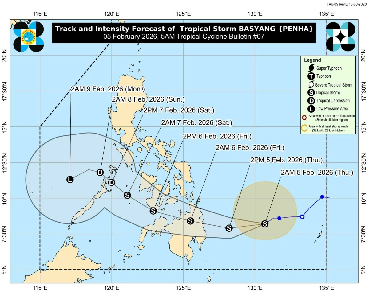
Forecast track and intensity for Tropical Storm Basyang (Penha) (Courtesy of PAGASA)
5 p.m., Feb. 6
Tropical Depression Basyang (Penha) was located over the vicinity of Dauis, Bohol, moving west-southwestward at 15 kilometers per hour, with maximum sustained winds of 55 kilometers per hour near the center and gusts of up to 75 kilometers per hour.
PAGASA said the cyclone is maintaining its strength as it moves across Central Visayas, but may weaken into a low pressure area within the next 12 hours.
Basyang made its initial landfall over Bayabas, Surigao del Norte at 11:50 p.m. on Thursday, Feb. 5, and its second landfall over Jagna, Bohol at 11 a.m. on Friday.
On the forecast track, the center of Basyang may make another landfall over the southern portions of Cebu and Negros Oriental between Friday and early Saturday, Feb. 7.
Afterwards, it is expected to head toward the southern portion of Panay Island or over Panay Gulf.
READ:
11 a.m., Feb. 6
Tropical Depression Basyang (Penha) was located over the coastal waters of Anda, Bohol, moving west-northwestward at 10 kilometers per hour, with maximum sustained winds of 55 kilometers per hour near the center and gusts of up to 70 kilometers per hour.
PAGASA said the cyclone weakened from a tropical storm into a tropical depression as it moved over the Bohol Sea.
On the forecast track, the center of Basyang may pass close to or make landfall over Bohol and the southern portions of Cebu and Negros Oriental in the coming hours.
Afterwards, it is expected to pass close to the southern portion of Panay Island by tomorrow afternoon or evening before weakening further.
READ:
8 a.m., Feb. 6
PAGASA said Tropical Storm Basyang (Penha) is now over Bohol Sea and heading towards Central Visayas.
On the forecast track, the center of Basyang may pass close or make landfall over Bohol and southern portions of Cebu and Negros Oriental as the storm moves west-northwestward in the coming hours.
Afterwards, it will emerge over the Sulu Sea, pass close to Cuyo Islands, and cross the northern portion of Palawan.
5 a.m., Feb. 6
Tropical Storm Basyang (Penha) was located in the vicinity of Jabonga, Agusan del Norte.
The storm was moving west-northwestward at 25 kilometers per hour, with maximum sustained winds of 65 kilometers per hour near the center and gusts of up to 90 kilometers per hour, PAGASA said.
On the forecast track, Basyang will continue traversing Agusan del Norte and is expected to emerge over the Bohol Sea this morning.
Between this morning and afternoon, it may pass close to or make another landfall over Bohol and the southern portions of Cebu and Negros Oriental.
Afterwards, the storm is forecast to move into the Sulu Sea, pass close to the Cuyo Islands, and cross the northern portion of Palawan.
It is expected to weaken gradually but may remain a tropical storm while moving across Central and Western Visayas.
READ:
2 a.m., Feb. 6
At 11:50 p.m. Thursday, Feb. 5, Tropical Storm Basyang (Penha) made landfall over Bayabas, Surigao del Norte.
PAGASA said the center of the storm was located in the vicinity of Cabadbaran City, Agusan del Norte, at 1 a.m. Friday.
On the forecast track, Basyang is expected to cross the Mindanao landmass, then traverse the Bohol Sea later this morning.
It may pass close to or make another landfall over the southern portions of Cebu and Negros Oriental.
By evening, the storm is forecast to emerge over the Sulu Sea and then traverse the northern portion of Palawan between Saturday afternoon and evening, Feb. 7.
11 p.m., Feb. 5
Tropical Storm Basyang (Penha) was located about 100 kilometers east-northeast of Hinatuan, Surigao del Sur, moving west-northwestward at 15 kilometers per hour.
It had maximum sustained winds of 75 kilometers per hour near the center and gustiness of up to 90 kilometers per hour.
PAGASA said the storm has slightly slowed down but continues to approach Surigao del Sur.
On the forecast track, Basyang is expected to make its initial landfall over Surigao del Sur tonight or early tomorrow morning, Feb. 6.
It will then cross Mindanao, emerge over the Bohol Sea tomorrow morning, and may pass close to or make another landfall over Siquijor and the southern portion of Negros Oriental by tomorrow afternoon to evening.
By tomorrow evening or early Saturday, Feb. 7, it is forecast to move into the Sulu Sea and traverse the northern portion of Palawan.
The storm is expected to weaken slightly after landfall due to land interaction but will likely remain a tropical storm.
8 p.m., Feb. 5
Tropical Storm Basyang (Penha) was located 115 kilometers east of Hinatuan, Surigao del Sur, moving west-northwestward at 20 kilometers per hour, with maximum sustained winds of 75 kilometers per hour near the center and gusts of up to 90 kilometers per hour.
On the forecast track, Basyang is expected to make its initial landfall over Surigao del Sur tonight or early tomorrow morning.
After crossing Mindanao, it is likely to emerge over the Bohol Sea tomorrow morning and may pass close to or make another landfall over Siquijor and the southern portion of Negros Oriental by tomorrow afternoon to evening.
By tomorrow evening or early Saturday, Feb. 7, it is forecast to emerge over the Sulu Sea and then traverse the northern portion of Palawan between Saturday afternoon and evening.
The storm is forecast to slightly weaken upon landfall due to land interaction but will likely remain a tropical storm.
READ:
5 p.m., Feb. 5
Tropical Storm Basyang (Penha) was located about 230 kilometers east of Hinatuan, Surigao del Sur, moving westward at around 25 kilometers per hour, with maximum sustained winds of 65 kilometers per hour near the center and gusts of up to 80 kilometers per hour.
PAGASA said Basyang will continue moving westward before turning west-northwestward, with initial landfall expected over Surigao del Sur between Thursday evening and early Friday, Feb. 6. After crossing Mindanao, the storm is likely to emerge over the Bohol Sea and may pass close to or make another landfall over Siquijor and the southern portion of Negros Oriental before moving into the Sulu Sea and toward northern Palawan.
2 p.m., Feb. 5
Tropical Storm Basyang (Penha) was located 230 kilometers east of Hinatuan, Surigao del Sur, moving westward at 25 kilometers per hour, with maximum sustained winds of 65 kilometers per hour near the center and gusts of up to 80 kilometers per hour.
On the forecast track, Basyang is expected to make initial landfall over Surigao del Sur later today, cross Mindanao, emerge over the Bohol Sea Friday morning, Feb. 6, and possibly pass close to or make another landfall over Siquijor and southern Negros Oriental before moving toward the Sulu Sea and northern Palawan.
11 a.m., Feb. 5
Tropical Storm Basyang (Penha) was located 295 kilometers east of Hinatuan, Surigao del Sur, moving westward at 25 kilometers per hour, with maximum sustained winds of 65 kilometers per hour and gusts of up to 80 kilometers per hour.
On the forecast track, Basyang is expected to make initial landfall over Surigao del Sur tonight, cross Mindanao, emerge over the Bohol Sea Friday morning, Feb. 6, and possibly pass close to or make another landfall over Siquijor and southern Negros Oriental before moving toward the Sulu Sea and northern Palawan.
8 a.m., Feb. 5
Tropical Storm Basyang was located 385 kilometers east of Hinatuan, Surigao del Sur, moving west-southwestward before turning generally westward, with maximum sustained winds of 65 kilometers per hour near the center and gusts of up to 80 kilometers per hour.
Basyang is forecast to make initial landfall over Surigao del Sur between Thursday night and early Friday, Feb. 6, before crossing Mindanao and emerging over the Bohol Sea Friday morning, possibly passing close to or making another landfall over Siquijor and the southern portion of Negros Oriental by Friday afternoon.
The storm may further intensify before its initial landfall, and although it is expected to weaken slightly from land interaction, it will likely remain a tropical storm before weakening into a tropical depression by Saturday and being downgraded to a low-pressure area by Monday, Feb. 9.
READ:
5 a.m., Feb. 5
PAGASA estimated the location of the center of Tropical Storm Basyang (international name: Penha) at 440 kilometers east of Hinatuan, Surigao del Sur.
It continues to move west-southwestward toward eastern Mindanao.
Based on its forecast track, PAGASA said Basyang may make landfall over Surigao del Sur between tonight and early Thursday, Feb. 6.
2 a.m., Feb. 5
The center of Tropical Storm Basyang (international name: Penha) was located 515 kilometers east of Hinatuan, Surigao del Sur.
It had maximum sustained winds of 65 kilometers per hour and gustiness of up to 80 kilometers per hour.
Basyang is expected to move westward for the next 24 hours before turning west-northwestward. It is likely to make landfall over eastern Mindanao on Friday morning, Feb. 6.
11 p.m., Feb. 4
Tropical Storm Basyang (international name: Penha) was located 560 kilometers east of Hinatuan, Surigao del Sur, moving westward at 15 kilometers per hour with maximum sustained winds of 65 kilometers per hour near the center and gusts of up to 80 kilometers per hour.
Tropical Cyclone Wind Signal No. 2 was raised as it intensified into a tropical storm.
Basyang is forecast to move generally westward for the next 24 hours before turning west-northwestward Thursday evening, Feb. 5, with initial landfall expected over eastern Mindanao between Thursday evening and early Friday, Feb. 6.
It will then traverse northeastern Mindanao and Central and Western Visayas before emerging over the Sulu Sea by Saturday morning, Feb. 7, and cross northern Palawan later that day.
The storm may intensify further over the Philippine Sea before landfall but is expected to weaken into a tropical depression while crossing the Visayas, and may be downgraded to a low-pressure area by Sunday, Feb. 8.
READ:
5 p.m., Feb. 4
Tropical Depression Basyang was located 655 kilometers east of Hinatuan, Surigao del Sur, moving westward at 15 kilometers per hour, with maximum sustained winds of 55 kilometers per hour near the center and gusts of up to 70 kilometers per hour.
Signal No. 1 has been raised over 12 areas in the Visayas and Mindanao.
PAGASA said minimal to minor impacts from strong winds are expected in areas under Signal No. 1, while the highest warning during Basyang’s passage may reach Signal No. 2.
Basyang is forecast to move generally westward before turning west-northwestward on Thursday evening, Feb. 5, with landfall expected over eastern Mindanao between Thursday evening and early Friday, Feb. 6.
It may intensify into a tropical storm over the Philippine Sea but is expected to weaken while crossing the Visayas, downgrading into a low-pressure area by Sunday, Feb. 8.
READ:
11 a.m., Feb. 4
The center of Tropical Depression Basyang was estimated at 735 kilometers east of Hinatuan, Surigao del Sur, moving southwestward at 15 kilometers per hour.
PAGASA said Basyang will move generally westward for the next 36 hours before turning west-northwestward, with landfall expected over eastern Mindanao between Thursday evening, Feb. 5, and Friday morning, Feb. 6.
The weather disturbance is forecast to gradually intensify over the Philippine Sea and may reach tropical storm category before landfall, but is expected to weaken while crossing the Visayas and be downgraded into a low pressure area by Sunday, Feb. 8.
Signal No. 1 was raised over Surigao del Sur and the eastern portion of Surigao del Norte, including the Siargao-Bucas Grande Islands, with the highest possible warning during its passage at Signal No. 2.
READ:
5 a.m., Feb. 4
The center of Tropical Depression Basyang was estimated at 895 kilometers east of northeastern Mindanao.
PAGASA said Basyang will move generally west-southwestward before turning west to west-northwest, with landfall expected over eastern Mindanao between Thursday evening, Feb. 5, and Friday morning, Feb. 6.
The weather disturbance may strengthen into a tropical storm over the Philippine Sea but is expected to weaken after landfall and be downgraded into a low pressure area by Monday, Feb. 9.
READ:
8 p.m., Feb. 3
Tropical Depression Basyang entered the Philippine Area of Responsibility on Tuesday evening and was last located 965 kilometers east of northeastern Mindanao.
It is expected to move generally west-southwestward before turning west to west-northwest, with landfall possible over eastern Mindanao or the southern portion of Eastern Visayas late Thursday or early Friday, Feb. 5 or 6.
PAGASA said the weather disturbance may strengthen into a tropical storm over the Philippine Sea before weakening again due to land interaction.
Signal No. 1 is expected to be raised over Caraga, with the highest possible warning during its passage at Signal No. 2.
READ: