ADVERTISEMENT

'Basyang' may intensify into tropical storm before landfall — PAGASA

Published Feb 4, 2026 02:08 pm
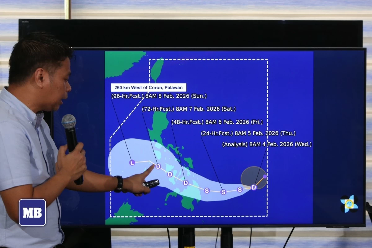
Philippine Atmospheric, Geophysical and Astronomical Services Administration (PAGASA) assistant weather services chief Chris Perez gives updates on Tropical Depression Basyang, the country’s second cyclone for 2026, during a briefing at the PAGASA Weather and Flood Forecasting Center in Quezon City on Wednesday, Feb. 4. (Santi San Juan/Manila Bulletin)
Tropical Depression Basyang may intensify into a tropical storm before making landfall over eastern Mindanao, the Philippine Atmospheric, Geophysical and Astronomical Services Administration (PAGASA) said, as the cyclone continued moving southwestward east of Mindanao on Wednesday, Feb.4.
The center of Basyang was estimated at 735 kilometers east of Hinatuan, Surigao del Sur at around 10 a.m., moving southwestward at 15 kilometers per hour (kph).
It is packing maximum sustained winds of 55 kph near the center and gustiness of up to 70 kph.
PAGASA assistant weather services chief Chris Perez said Basyang is forecast to gradually intensify while over the Philippine Sea and may reach tropical storm category before landfall.
However, the cyclone is expected to weaken back into a tropical depression while crossing the Visayas and may be downgraded into a low pressure area by Sunday, Feb. 8.
As of 11 a.m. on Wednesday, PAGASA raised tropical cyclone wind signal No. 1 over Surigao del Sur and the eastern portion of Surigao del Norte, particularly Claver, Gigaquit, and Bacuag, including the Siargao-Bucas Grande Islands.
Minimal to minor impacts from strong winds are possible in these areas, it said.
PAGASA added that the highest wind signal that may be hoisted during Basyang’s passage is Signal No. 2.
Based on its latest forecast track, Basyang is expected to move generally westward for the next 36 hours before turning west-northwestward beginning Thursday evening, Feb. 5.
PAGASA said the cyclone’s center is projected to make its initial landfall over eastern Mindanao between Thursday evening and Friday morning, Feb. 6.
After landfall, Basyang is forecast to traverse northeastern Mindanao and Central and Western Visayas and emerge over the Sulu Sea by Saturday morning, Feb. 7.
By Saturday afternoon or evening, it is expected to cross the northern portion of Palawan before re-emerging over the West Philippine Sea.

Related Tags

PAGASA TROPICAL DEPRESSION BASYANG SIGNAL NO. 1 LANDFALL
ADVERTISEMENT
.most-popular .layout-ratio{ padding-bottom: 79.13%; } @media (min-width: 768px) and (max-width: 1024px) { .widget-title { font-size: 15px !important; } }

{{ articles_filter_1561_widget.title }}

.most-popular .layout-ratio{ padding-bottom: 79.13%; } @media (min-width: 768px) and (max-width: 1024px) { .widget-title { font-size: 15px !important; } }

{{ articles_filter_1562_widget.title }}

.most-popular .layout-ratio{ padding-bottom: 79.13%; } @media (min-width: 768px) and (max-width: 1024px) { .widget-title { font-size: 15px !important; } }

{{ articles_filter_1563_widget.title }}

{{ articles_filter_1564_widget.title }}

.mb-article-details { position: relative; } .mb-article-details .article-body-preview, .mb-article-details .article-body-summary{ font-size: 17px; line-height: 30px; font-family: "Libre Caslon Text", serif; color: #000; } .mb-article-details .article-body-preview iframe , .mb-article-details .article-body-summary iframe{ width: 100%; margin: auto; } .read-more-background { background: linear-gradient(180deg, color(display-p3 1.000 1.000 1.000 / 0) 13.75%, color(display-p3 1.000 1.000 1.000 / 0.8) 30.79%, color(display-p3 1.000 1.000 1.000) 72.5%); position: absolute; height: 200px; width: 100%; bottom: 0; display: flex; justify-content: center; align-items: center; padding: 0; } .read-more-background a{ color: #000; } .read-more-btn { padding: 17px 45px; font-family: Inter; font-weight: 700; font-size: 18px; line-height: 16px; text-align: center; vertical-align: middle; border: 1px solid black; background-color: white; } .hidden { display: none; }
function initializeAllSwipers() { // Get all hidden inputs with cms_article_id document.querySelectorAll('[id^="cms_article_id_"]').forEach(function (input) { const cmsArticleId = input.value; const articleSelector = '#article-' + cmsArticleId + ' .body_images'; const swiperElement = document.querySelector(articleSelector); if (swiperElement && !swiperElement.classList.contains('swiper-initialized')) { new Swiper(articleSelector, { loop: true, pagination: false, navigation: { nextEl: '#article-' + cmsArticleId + ' .swiper-button-next', prevEl: '#article-' + cmsArticleId + ' .swiper-button-prev', }, }); } }); } setTimeout(initializeAllSwipers, 3000); const intersectionObserver = new IntersectionObserver( (entries) => { entries.forEach((entry) => { if (entry.isIntersecting) { const newUrl = entry.target.getAttribute("data-url"); if (newUrl) { history.pushState(null, null, newUrl); let article = entry.target; // Extract metadata const author = article.querySelector('.author-section').textContent.replace('By', '').trim(); const section = article.querySelector('.section-info ').textContent.replace(' ', ' '); const title = article.querySelector('.article-title h1').textContent; // Parse URL for Chartbeat path format const parsedUrl = new URL(newUrl, window.location.origin); const cleanUrl = parsedUrl.host + parsedUrl.pathname; // Update Chartbeat configuration if (typeof window._sf_async_config !== 'undefined') { window._sf_async_config.path = cleanUrl; window._sf_async_config.sections = section; window._sf_async_config.authors = author; } // Track virtual page view with Chartbeat if (typeof pSUPERFLY !== 'undefined' && typeof pSUPERFLY.virtualPage === 'function') { try { pSUPERFLY.virtualPage({ path: cleanUrl, title: title, sections: section, authors: author }); } catch (error) { console.error('ping error', error); } } // Optional: Update document title if (title && title !== document.title) { document.title = title; } } } }); }, { threshold: 0.1 } ); function showArticleBody(button) { const article = button.closest("article"); const summary = article.querySelector(".article-body-summary"); const body = article.querySelector(".article-body-preview"); const readMoreSection = article.querySelector(".read-more-background"); // Hide summary and read-more section summary.style.display = "none"; readMoreSection.style.display = "none"; // Show the full article body body.classList.remove("hidden"); } document.addEventListener("DOMContentLoaded", () => { let loadCount = 0; // Track how many times articles are loaded const offset = [1, 2, 3, 4, 5, 6, 7, 8, 9, 10]; // Offset values const currentUrl = window.location.pathname.substring(1); let isLoading = false; // Prevent multiple calls if (!currentUrl) { console.log("Current URL is invalid."); return; } const sentinel = document.getElementById("load-more-sentinel"); if (!sentinel) { console.log("Sentinel element not found."); return; } function isSentinelVisible() { const rect = sentinel.getBoundingClientRect(); return ( rect.top < window.innerHeight && rect.bottom >= 0 ); } function onScroll() { if (isLoading) return; if (isSentinelVisible()) { if (loadCount >= offset.length) { console.log("Maximum load attempts reached."); window.removeEventListener("scroll", onScroll); return; } isLoading = true; const currentOffset = offset[loadCount]; window.loadMoreItems().then(() => { let article = document.querySelector('#widget_1690 > div:nth-last-of-type(2) article'); intersectionObserver.observe(article) loadCount++; }).catch(error => { console.error("Error loading more items:", error); }).finally(() => { isLoading = false; }); } } window.addEventListener("scroll", onScroll); });

Sign up by email to receive news.