


Manila Bulletin
 Philippines
National
Wind signals hoisted over more areas as 'Basyang' accelerates toward eastern Mindanao
Philippines
National
Wind signals hoisted over more areas as 'Basyang' accelerates toward eastern Mindanao
Philippines
National
Wind signals hoisted over more areas as 'Basyang' accelerates toward eastern Mindanao
Wind signals hoisted over more areas as 'Basyang' accelerates toward eastern Mindanao
Published Feb 5, 2026 08:49 am


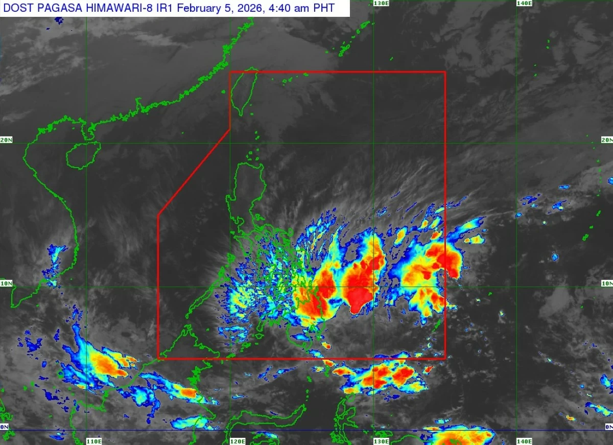
Satellite image of Tropical Storm Basyang (international name: Penha) (Courtesy of PAGASA)
The Philippine Atmospheric, Geophysical and Astronomical Services Administration (PAGASA) on Thursday morning, Feb. 5 said Tropical Storm Basyang (international name: Penha) had accelerated as it moved closer to eastern Mindanao, with more areas placed under tropical cyclone wind signals ahead of its expected landfall in Surigao del Sur.
As of 7 a.m., the center of Basyang was located 385 kilometers east of Hinatuan, Surigao del Sur, with maximum sustained winds of 65 kilometers per hour (kph) near the center and gusts of up to 80 kph.
The storm was moving west-southwestward, and was forecast to shift to a generally westward track before turning west-northwestward beginning Friday morning, Feb. 6.
Signal No. 2 has been hoisted over Surigao del Norte including Siargao-Bucas Grande Islands, Surigao del Sur, extreme northern portion of Davao Oriental (Boston), Agusan del Norte, Agusan del Sur, Misamis Oriental, northern portion of Bukidnon (Impasug-Ong, Manolo Fortich, Malitbog, Sumilao, Libona, Baungon, City of Malaybalay, Cabanglasan), northeastern portion of Lanao del Norte (Iligan City), northeastern portion of Misamis Occidental (Baliangao, Plaridel, Lopez Jaena, Oroquieta City, Calamba, Aloran, Panaon), and Camiguin.
Signal No. 1 is in effect over Cuyo Islands; southern portion of Eastern Samar (Guiuan, Salcedo, Mercedes, Giporlos, Balangiga, Lawaan, Quinapondan, General MacArthur, Hernani, Llorente, Balangkayan); southern portion of Samar (Marabut, Basey, Santa Rita); Biliran; Leyte; Southern Leyte; Bohol; Cebu; Siquijor; Negros Oriental; Negros Occidental; Guimaras; Iloilo; Capiz; Aklan; Antique; Dinagat Islands; northern and central portions of Davao Oriental (Cateel, Baganga, Caraga, Manay, Tarragona, Lupon, Banaybanay); Davao de Oro; Davao del Norte; northern portion of Davao del Sur (Davao City); the rest of Bukidnon; northern portion of Cotabato (Carmen, Banisilan, Alamada, President Roxas, Antipas, Arakan, Magpet, Matalam, Kabacan); Lanao del Sur; northern portion of Maguindanao del Norte (Buldon, Barira, Matanog); the rest of Lanao del Norte; the rest of Misamis Occidental; eastern and central portions of Zamboanga del Norte (Mutia, Piñan, Polanco, Dipolog City, Dapitan City, Sibutad, Rizal, La Libertad, Labason, Kalawit, Liloy, Salug, Bacungan, Sindangan, Jose Dalman, Manukan, President Manuel A. Roxas, Katipunan, Sergio Osmeña Sr., Siayan, Godod, Tampilisan, Gutalac); northern and central portions of Zamboanga del Sur (Bayog, Kumalarang, Lapuyan, San Miguel, Guipos, Dinas, San Pablo, Dumalinao, Pagadian City, Tigbao, Lakewood, Dumingag, Mahayag, Molave, Josefina, Tambulig, Aurora, Ramon Magsaysay, Sominot, Midsalip, Labangan, Tukuran); and northern portion of Zamboanga Sibugay (Kabasalan, Diplahan, Naga, Titay, Ipil, Buug).
PAGASA warned that heavy rains may prevail over Caraga, Davao Region, Northern Mindanao, Eastern Samar, Leyte, Southern Leyte, Cebu, Bohol, and Siquijor over the next 24 hours, while the rest of Visayas, the rest of Mindanao, and Masbate may experience scattered moderate to heavy rains.
The weather bureau also warned of a minimal to moderate risk of storm surge, with peak heights reaching up to two meters within the next 48 hours over low-lying or exposed coastal communities in Dinagat Islands, Surigao del Norte, Surigao del Sur, Agusan del Norte, Davao Oriental, Misamis Oriental, Camiguin, Leyte, Southern Leyte, Cebu, Bohol, Negros Oriental, Negros Occidental, Antique, and Cagayancillo Islands.
A gale warning remains in effect over eastern seaboards of Visayas and Mindanao. Mariners of small seacrafts, including motorbancas, are advised not to venture out to sea, especially if inexperienced or operating ill-equipped vessels.
PAGASA said Basyang is expected to make initial landfall over Surigao del Sur between Thursday evening and early Friday, Feb. 6.
After crossing Mindanao, the storm is likely to emerge over Bohol Sea on Friday morning and may pass close to or make another landfall over Siquijor and southern portion of Negros Oriental by Friday afternoon.
By Friday evening or early Saturday, Feb. 7, Basyang is expected to move over Sulu Sea and then traverse northern portion of Palawan between Saturday afternoon and evening.
Basyang may still intensify before its initial landfall, but it is expected to weaken slightly as it interacts with land, although it will likely remain a tropical storm.
Further weakening into a tropical depression is forecast by Saturday, with a possible downgrade into a low-pressure area by Monday, Feb. 9.