


Tropical cyclone outside PAR intensifies into a super typhoon
Published Jul 3, 2026 11:19 pm


At A Glance
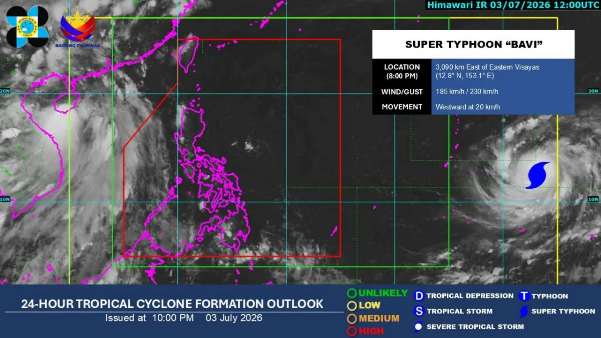
- As of 10 p.m., the super typhoon was packing maximum sustained winds of 185 kilometers per hour (kph) near the center and gustiness of up to 230 kph.
Satellite image of a super typhoon outside the Philippine area of responsibility (PAGASA)
The tropical cyclone internationally named “Bavi” rapidly strengthened into a super typhoon on Friday evening, July 3, as it continued moving westward outside the Philippine area of responsibility (PAR), the Philippine Atmospheric, Geophysical and Astronomical Services Administration (PAGASA) said.
As of 10 p.m., the super typhoon was packing maximum sustained winds of 185 kilometers per hour (kph) near the center and gustiness of up to 230 kph.
Its location was estimated at 3,090 kilometers east of Eastern Visayas and was moving westward at 20 kph.
In the 5 p.m. public weather forecast, PAGASA weather specialist Loriedin dela Cruz-Galicia said the cyclone may enter the PAR by Wednesday, July 8, when it will be assigned the local name “Inday.”
Based on PAGASA’s latest tropical cyclone threat assessment, the super typhoon has a high chance of approaching Northern Luzon next week.
“Dahil diyan likely ho magtaas tayo ng tropical cyclone wind signal sa malaking bahagi ng Northern Luzon at posible rin sa ilang bahagi ng Central Luzon (Because of this, we are likely to raise tropical cyclone wind signals over a large part of Northern Luzon and possibly in some areas of Central Luzon),” she said.
Dela Cruz-Galicia said the typhoon is also expected to enhance the southwest monsoon, or “habagat,” which may bring widespread rains over a large part of the country next week.
She urged the public to continue monitoring PAGASA advisories, saying significant changes in the forecast remain possible because the super typhoon is still far from the country.
READ: