







Extreme rainfall consistent with El Niño pattern — PAGASA
Published Aug 17, 2026 05:49 pm


At A Glance
- PAGASA had warned as early as April that El Niño could make the southwest monsoon or "habagat" more active this year, resulting in above-normal rainfall over parts of the country.
- That pattern is now being observed as the habagat continues to affect the country, bringing heavy rains over parts of Luzon and the Visayas.
- "The habagat will continue to bring rains over the western portions of the country in August. Flash floods and landslides may occur during extreme rainfall events," PAGASA warned.
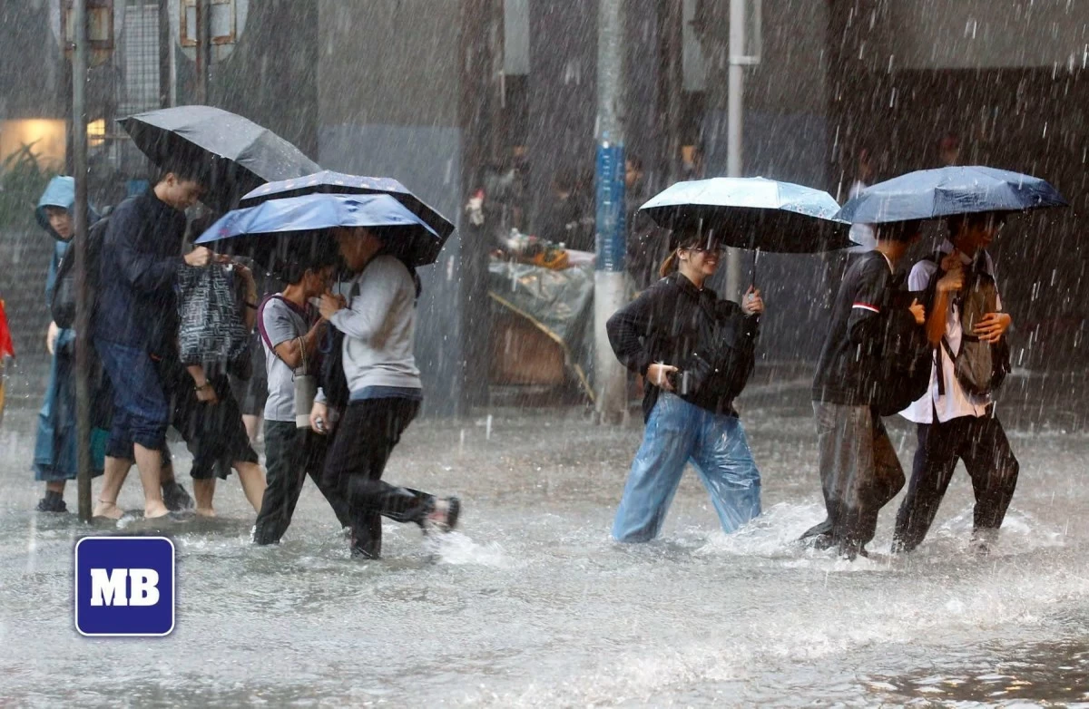
People wade through floodwaters along Taft Ave. in Manila on August 17, 2026, following heavy rains brought by the southwest monsoon, or “habagat.” Several roads in Metro Manila were reported flooded on Monday, disrupting transportation and leaving commuters stranded. (Mark Balmores/Manila Bulletin)
The extreme rainfall events being experienced in parts of the country are consistent with the rainfall pattern typically observed during El Niño, the Philippine Atmospheric, Geophysical and Astronomical Services Administration (PAGASA) said on Monday, Aug. 17.
PAGASA had warned as early as April that El Niño could make the southwest monsoon or “habagat” more active this year, resulting in above-normal rainfall over parts of the country.
RELATED STORY:
Above-normal rainfall is usually observed over the western portions of the country from July to September during El Niño conditions, PAGASA said.
That pattern is now being observed as the habagat continues to affect the country, bringing heavy rains over parts of Luzon and the Visayas.
“The habagat will continue to bring rains over the western portions of the country in August. Flash floods and landslides may occur during extreme rainfall events,” PAGASA warned.
Rainy days ahead
PAGASA weather specialist Charmagne Varilla said the habagat continued to bring heavy rains over most of Central Luzon and the western sections of Northern Luzon, Southern Luzon, and the Visayas on Monday.
Moderate to heavy monsoon rains were also prevailing over the rest of Luzon.
PAGASA warned that more intense rains compared to last week may persist this week.
The weather bureau forecast 100 to 200 millimeters of rainfall, considered heavy to intense, from Monday to Tuesday noon, Aug. 18, over Benguet, La Union, Pangasinan, Zambales, and Bataan.
Metro Manila, Ilocos Sur, Abra, Tarlac, Pampanga, Bulacan, Rizal, Cavite, Batangas, and Occidental Mindoro may receive 50 to 100 millimeters of rainfall, considered as moderate to heavy, during the same period.
From Tuesday noon to Wednesday noon, Aug. 19, Benguet, La Union, Pangasinan, Zambales, Bataan, and Occidental Mindoro may receive 100 to 200 millimeters of rainfall.
Meanwhile, Metro Manila, Ilocos Sur, Tarlac, Pampanga, Bulacan, Cavite, Batangas, Rizal, Laguna, and Antique may receive 50 to 100 millimeters.
From Wednesday noon to Thursday noon, Aug. 20, Zambales, Bataan, and Occidental Mindoro may receive 100 to 200 millimeters of rainfall.
Moderate to heavy rainfall may persist in Metro Manila, Ilocos Sur, La Union, Benguet, Pangasinan, Tarlac, Pampanga, Bulacan, Rizal, Cavite, Laguna, and Batangas.
PAGASA warned that areas expected to receive heavy to intense rainfall may experience “numerous flooding events,” particularly in urbanized, low-lying, and river-adjacent areas.
“Landslides are also likely in moderate to highly susceptible areas,” PAGASA said.
Areas expected to receive moderate to heavy rainfall may experience localized flooding, particularly in urbanized, low-lying, and river-adjacent areas.
“Landslides are also likely in highly susceptible areas,” it added.
LPA may sustain ‘habagat’ rains
As of Monday afternoon, Varilla said LPA 08f was located 1,160 kilometers east of Northern Luzon and had a “medium” chance of developing into a tropical depression within the next two days.
She said there are two possible scenarios for the LPA’s development.
“Una, kapag ito ay naging ganap na bagyo ay maaari itong maging parte ng tinatawag nating monsoon trough o yung dinadaanan ng hanging habagat (First, if it develops into a full-fledged cyclone, it could become part of the so-called monsoon trough, or the area where the habagat passes),” Varilla said.
“Samantala, kung hindi ito matutuloy na maging isang bagyo at mauunahan ng isang posibleng bagyo sa may bahagi ng China ay mas mababa na ang tsansa nito mag-develop at maaaring malusaw at mas magpre-prevail yung bagyo dito sa kanlurang bahagi ng ating bansa (Meanwhile, if it does not develop into a cyclone and is overtaken by a possible storm near China, its chances of developing will become lower and it may dissipate, allowing the storm over the western portion of the country to prevail),” she added.
However, Varilla said either scenario could still strengthen the habagat and prolong the rains over the country this week.
“Alin man sa mga scenario na nabanggit sa development ng sa posibleng dalawang low-pressure area ay maaari pa ring maghatak ng habagat na siyang patuloy na magpapaulan within this week sa ating bansa, especially sa Luzon at Visayas (Regardless of which of the scenarios occurs in the development of the possible two low-pressure areas, they may still draw in the habagat, which will continue to bring rains to the country this week, especially over Luzon and the Visayas),” she said.