


37 areas swelter under 'dangerous' heat on May 8
Published May 8, 2026 07:39 pm


At A Glance
- PAGASA said the easterlies continue to bring hot and humid weather across the country.
PAGASA
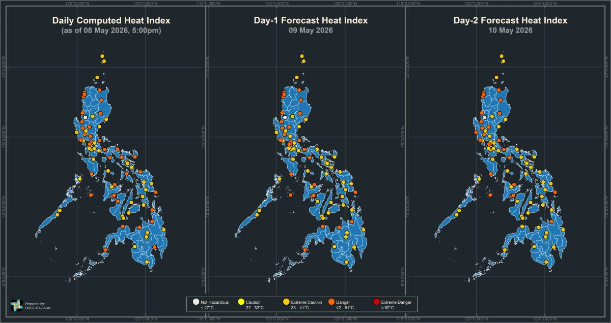
Despite a tropical storm approaching the Philippine Area of Responsibility (PAR), several areas across the country still recorded dangerous heat index levels ranging from 42°C to 44°C on Friday, May 8, based on the monitoring of the Philippine Atmospheric, Geophysical and Astronomical Services Administration (PAGASA).
According to PAGASA, 11 areas posted the highest heat index of 44°C:
* Laoag City, Ilocos Norte
* Dagupan City, Pangasinan
* Echague, Isabela
* Muñoz, Nueva Ecija
* Cubi Point, Subic Bay
* Olongapo City
* Camiling, Tarlac
* Alabat, Quezon
* Cuyo, Palawan
* Roxas City, Capiz
* Dumangas, Iloilo
* Butuan City, Agusan del Norte
Areas that recorded a 43°C heat index were:
* Batac, Ilocos Norte
* Bacnotan, La Union
* Aparri, Cagayan
* Tuguegarao City, Cagayan
* Sangley Point, Cavite City
* San Jose, Occidental Mindoro
* Masbate City, Masbate
* Iloilo City, Iloilo
* Laguindingan Airport, Misamis Oriental
Meanwhile, 17 other areas registered a 42°C heat index:
* Science Garden, Quezon City, Metro Manila
* Sinait, Ilocos Sur
* Clark Airport, Pampanga
* San Ildefonso, Bulacan
* Infanta, Quezon
* Mulanay, Quezon
* Daet, Camarines Norte
* Legazpi City, Albay
* Virac, Catanduanes
* Pili, Camarines Sur
* La Granja, La Carlota City, Negros Occidental
* Catarman, Northern Samar
* Guiuan, Eastern Samar
* Dipolog, Zamboanga del Norte
* Zamboanga City, Zamboanga del Sur
* Davao City, Davao del Sur
* Surigao City, Surigao del Norte
Under PAGASA’s heat index classification, temperatures ranging from 42°C to 51°C fall under the “danger” category, where heat cramps and heat exhaustion are likely and heat stroke becomes possible with prolonged exposure.
READ MORE:
PAGASA weather specialist Obet Badrina said the easterlies continue to bring hot and humid weather across the country.
“The easterlies continue to affect the country, bringing hot and humid conditions, although they may also trigger rain showers or thunderstorms in some areas,” he said.
Meanwhile, PAGASA continues to monitor tropical storm “Hagupit,” which was located 1,385 kilometers east of northeastern Mindanao as of Friday afternoon.
The storm was moving westward at 20 kilometers per hour and is expected to enter the PAR by Saturday noon, May 9, when it will be assigned the local name “Caloy.”
Badrina said the cyclone is seen to gradually weaken and could be downgraded into a low-pressure area early next week.
While Hagupit is not expected to make landfall, he said it may still spawn rains over the southern portion of Bicol Region and Eastern Visayas in the coming days.
Despite the approaching storm, dangerous heat conditions are expected to persist on Saturday.
PAGASA said 28 areas, including Metro Manila, may still experience heat index levels under the danger category.