ADVERTISEMENT

'Wilma' slows down, likely to make landfall in Eastern or Northern Samar on December 6 — PAGASA

Published Dec 6, 2025 06:23 pm
Tropical Depression Wilma remains nearly stationary off Eastern Samar on December 6, 2026 as PAGASA warns of possible landfall in Eastern or Northern Samar, bringing heavy rains and hazardous seas across Eastern Visayas. (PAGASA)
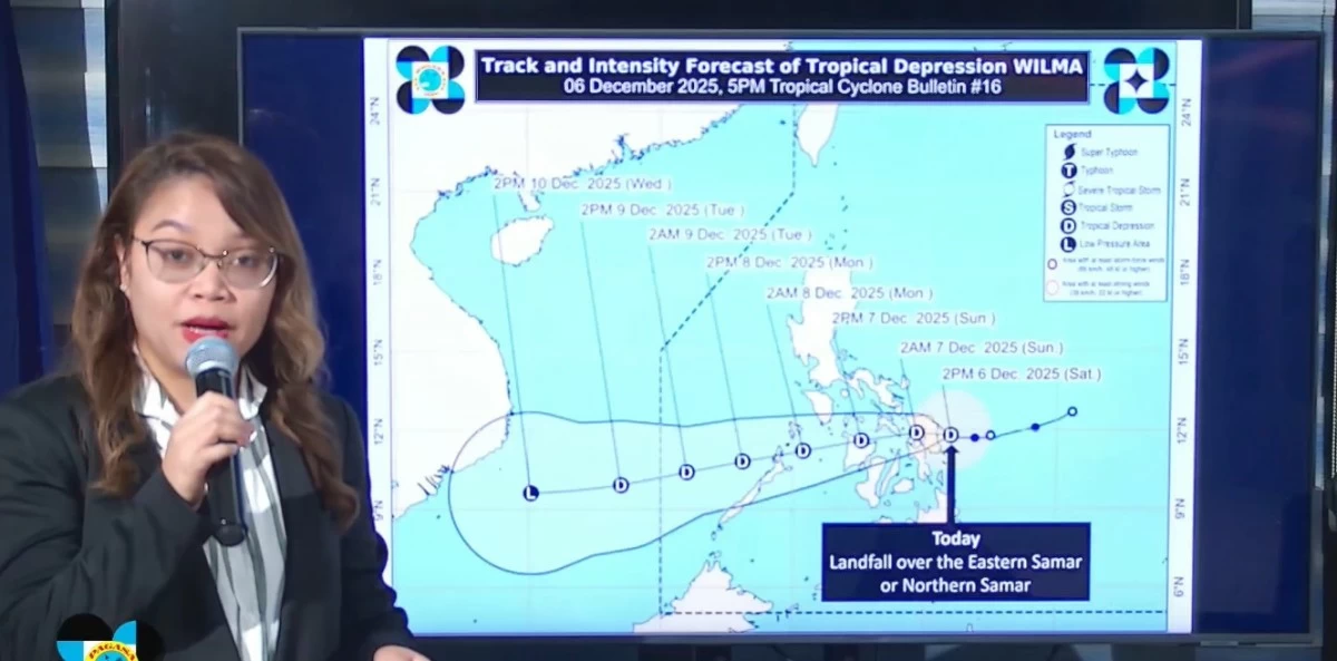
Tropical Depression Wilma has slowed down significantly and is now almost stationary over the coastal waters of Eastern Samar, increasing the likelihood of landfall within the next several hours, the Philippine Atmospheric, Geophysical and Astronomical Services Administration (PAGASA) said on Saturday, December 6.
In its latest press briefing, PAGASA weather specialist Charmagne Varilla said the system’s nearly stationary movement is a key factor behind the intensifying rainfall over Eastern Visayas.
“Bumagal ang pagkilos nito at sa ngayon, almost stationary (Its movement has slowed down and for now, it is almost stationary),” Varilla said.
She added that the shear line and northeast monsoon (amihan) are also bringing rains to various parts of the country.
Landfall possible ‘anytime’
Varilla emphasized that the latest forecast track places several areas on heightened alert for a potential direct hit.
“Base sa latest forecast track ng PAGASA, inaasahan nga natin na anumang oras mula ngayon ay maaari nang mag-landfall either dito sa may Eastern Samar or Northern Samar itong si Bagyong Wilma (Based on PAGASA’s latest forecast track, we expect that at any time from now, Tropical Depression Wilma may make landfall either in Eastern Samar or Northern Samar),” she said.
In its 5 p.m. tropical cyclone bulletin, PAGASA said a slight westward drift could bring the storm’s center across coastal municipalities in Eastern Samar or Northern Samar, placing communities at risk of flooding, storm-enhanced rains, and possible landslides.
The areas under Signal No. 1 include:
Luzon - Sorsogon; Masbate, including Ticao and Burias Islands; Romblon; the southern portion of Oriental Mindoro (Bulalacao, Mansalay, Roxas, Bongabong, Bansud); the southern portion of Occidental Mindoro (Magsaysay, San Jose, Rizal, Calintaan, Sablayan); and the northernmost portion of Palawan (Araceli, Dumaran, El Nido, Taytay, Roxas, San Vicente), including Cuyo, Calamian, and Cagayancillo Islands.
Visayas - Northern Samar, Eastern Samar, Samar, Biliran; the northern and central portions of Leyte (Tunga, Pastrana, San Miguel, Mahaplag, Matag-Ob, Tolosa, Palo, Calubian, Leyte, Mayorga, Julita, Carigara, Babatngon, Dagami, Inopacan, Jaro, Abuyog, San Isidro, Santa Fe, Albuera, Villaba, La Paz, Palompon, MacArthur, Tabontabon, Tanauan, Merida, Ormoc City, Isabel, Javier, Dulag, Capoocan, Alangalang, Hindang, Baybay City, Burauen, Tabango, Tacloban City, Kananga, Barugo); the northern and central portions of Cebu (Daanbantayan, Medellin, Bogo City, San Remigio, Tabogon, Borbon, Tabuelan, Tuburan, Sogod, Catmon, Asturias, Carmen, Danao City, Balamban, Compostela, Liloan, Consolacion, Mandaue City, Cebu City, Talisay City, Minglanilla, Toledo City, Pinamungahan, Naga City, Lapu-Lapu City, Cordova), including Bantayan and Camotes Islands; the northern portion of Negros Oriental (Canlaon City, Vallehermoso, Guihulngan City); the northern and central portions of Negros Occidental (Sagay City, Escalante City, Toboso, Calatrava, Enrique B. Magalona, Victorias City, Manapla, Cadiz City, Bacolod City, Talisay City, Silay City, Salvador Benedicto, San Carlos City, Murcia, Bago City, La Carlota City, La Castellana, Moises Padilla, Valladolid, Pulupandan, San Enrique, Pontevedra, Isabela, Hinigaran); Guimaras; Iloilo; Capiz; Aklan; and Antique, including the Caluya Islands.
Heavy rainfall and hazardous conditions
PAGASA warned of heavy to intense rainfall over Eastern Samar, Northern Samar, Samar Province, and parts of the Bicol Region.
These conditions are expected to persist due to the combined effects of Wilma, the shear line, and the amihan—factors that may worsen flooding in low-lying communities and increase the likelihood of rain-induced landslides in upland areas, the state weather bureau said.
Coastal risks and sea conditions
Moderate to rough seas continue to threaten the eastern seaboard of Samar Island.
PAGASA advised fisherfolk and operators of small vessels to avoid sea travel as sea conditions may further deteriorate with Wilma’s possible landfall.
RELATED STORY: 
https://mb.com.ph/2025/12/04/tropical-cyclone-wilma-tracker

Related Tags

Tropical Depression Wilma WilmaPH PAGASA PAGASA weather update Wilma landfall
ADVERTISEMENT
.most-popular .layout-ratio{ padding-bottom: 79.13%; } @media (min-width: 768px) and (max-width: 1024px) { .widget-title { font-size: 15px !important; } }

{{ articles_filter_1561_widget.title }}

.most-popular .layout-ratio{ padding-bottom: 79.13%; } @media (min-width: 768px) and (max-width: 1024px) { .widget-title { font-size: 15px !important; } }

{{ articles_filter_1562_widget.title }}

.most-popular .layout-ratio{ padding-bottom: 79.13%; } @media (min-width: 768px) and (max-width: 1024px) { .widget-title { font-size: 15px !important; } }

{{ articles_filter_1563_widget.title }}

{{ articles_filter_1564_widget.title }}

.mb-article-details { position: relative; } .mb-article-details .article-body-preview, .mb-article-details .article-body-summary{ font-size: 17px; line-height: 30px; font-family: "Libre Caslon Text", serif; color: #000; } .mb-article-details .article-body-preview iframe , .mb-article-details .article-body-summary iframe{ width: 100%; margin: auto; } .read-more-background { background: linear-gradient(180deg, color(display-p3 1.000 1.000 1.000 / 0) 13.75%, color(display-p3 1.000 1.000 1.000 / 0.8) 30.79%, color(display-p3 1.000 1.000 1.000) 72.5%); position: absolute; height: 200px; width: 100%; bottom: 0; display: flex; justify-content: center; align-items: center; padding: 0; } .read-more-background a{ color: #000; } .read-more-btn { padding: 17px 45px; font-family: Inter; font-weight: 700; font-size: 18px; line-height: 16px; text-align: center; vertical-align: middle; border: 1px solid black; background-color: white; } .hidden { display: none; }
function initializeAllSwipers() { // Get all hidden inputs with cms_article_id document.querySelectorAll('[id^="cms_article_id_"]').forEach(function (input) { const cmsArticleId = input.value; const articleSelector = '#article-' + cmsArticleId + ' .body_images'; const swiperElement = document.querySelector(articleSelector); if (swiperElement && !swiperElement.classList.contains('swiper-initialized')) { new Swiper(articleSelector, { loop: true, pagination: false, navigation: { nextEl: '#article-' + cmsArticleId + ' .swiper-button-next', prevEl: '#article-' + cmsArticleId + ' .swiper-button-prev', }, }); } }); } setTimeout(initializeAllSwipers, 3000); const intersectionObserver = new IntersectionObserver( (entries) => { entries.forEach((entry) => { if (entry.isIntersecting) { const newUrl = entry.target.getAttribute("data-url"); if (newUrl) { history.pushState(null, null, newUrl); let article = entry.target; // Extract metadata const author = article.querySelector('.author-section').textContent.replace('By', '').trim(); const section = article.querySelector('.section-info ').textContent.replace(' ', ' '); const title = article.querySelector('.article-title h1').textContent; // Parse URL for Chartbeat path format const parsedUrl = new URL(newUrl, window.location.origin); const cleanUrl = parsedUrl.host + parsedUrl.pathname; // Update Chartbeat configuration if (typeof window._sf_async_config !== 'undefined') { window._sf_async_config.path = cleanUrl; window._sf_async_config.sections = section; window._sf_async_config.authors = author; } // Track virtual page view with Chartbeat if (typeof pSUPERFLY !== 'undefined' && typeof pSUPERFLY.virtualPage === 'function') { try { pSUPERFLY.virtualPage({ path: cleanUrl, title: title, sections: section, authors: author }); } catch (error) { console.error('ping error', error); } } // Optional: Update document title if (title && title !== document.title) { document.title = title; } } } }); }, { threshold: 0.1 } ); function showArticleBody(button) { const article = button.closest("article"); const summary = article.querySelector(".article-body-summary"); const body = article.querySelector(".article-body-preview"); const readMoreSection = article.querySelector(".read-more-background"); // Hide summary and read-more section summary.style.display = "none"; readMoreSection.style.display = "none"; // Show the full article body body.classList.remove("hidden"); } document.addEventListener("DOMContentLoaded", () => { let loadCount = 0; // Track how many times articles are loaded const offset = [1, 2, 3, 4, 5, 6, 7, 8, 9, 10]; // Offset values const currentUrl = window.location.pathname.substring(1); let isLoading = false; // Prevent multiple calls if (!currentUrl) { console.log("Current URL is invalid."); return; } const sentinel = document.getElementById("load-more-sentinel"); if (!sentinel) { console.log("Sentinel element not found."); return; } function isSentinelVisible() { const rect = sentinel.getBoundingClientRect(); return ( rect.top < window.innerHeight && rect.bottom >= 0 ); } function onScroll() { if (isLoading) return; if (isSentinelVisible()) { if (loadCount >= offset.length) { console.log("Maximum load attempts reached."); window.removeEventListener("scroll", onScroll); return; } isLoading = true; const currentOffset = offset[loadCount]; window.loadMoreItems().then(() => { let article = document.querySelector('#widget_1690 > div:nth-last-of-type(2) article'); intersectionObserver.observe(article) loadCount++; }).catch(error => { console.error("Error loading more items:", error); }).finally(() => { isLoading = false; }); } } window.addEventListener("scroll", onScroll); });

Sign up by email to receive news.