


Manila Bulletin
 Philippines
National
'Wilma' maintains strength as it nears Eastern Visayas; Signal No. 1 up in more areas
Philippines
National
'Wilma' maintains strength as it nears Eastern Visayas; Signal No. 1 up in more areas
Philippines
National
'Wilma' maintains strength as it nears Eastern Visayas; Signal No. 1 up in more areas
'Wilma' maintains strength as it nears Eastern Visayas; Signal No. 1 up in more areas
Published Dec 6, 2025 10:05 am


(PAGASA)
Tropical Depression Wilma continued to maintain its strength as it moved slowly westward toward Eastern Visayas on Saturday, December 6, according to successive bulletins issued by the Philippine Atmospheric, Geophysical and Astronomical Services Administration (PAGASA).
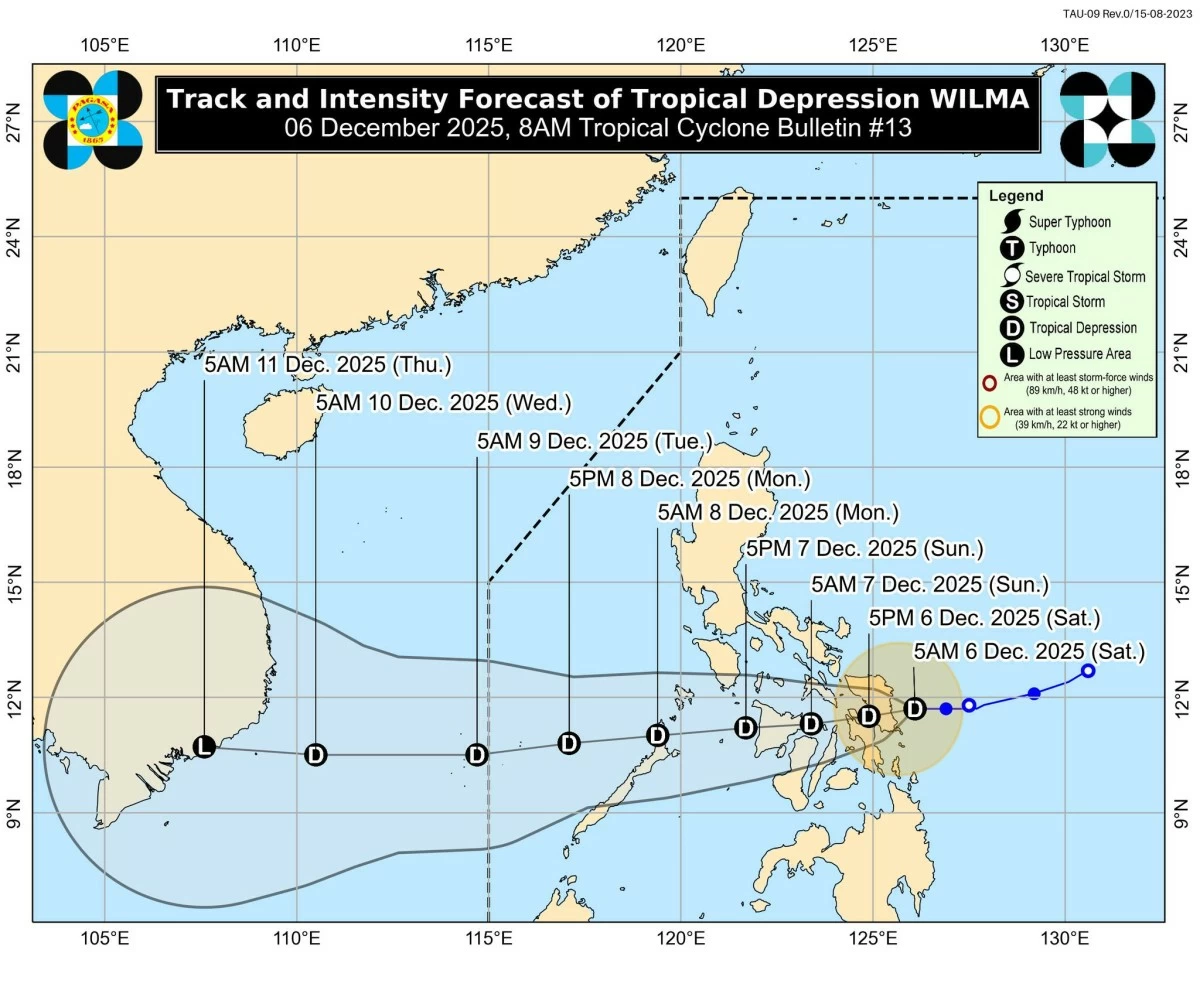
In its Tropical Cyclone Bulletin released at 8 a.m., PAGASA said the center of Wilma was estimated to be 70 km east of Borongan City, Eastern Samar.
The system carries maximum sustained winds of 45 km/h, gustiness of up to 55 km/h, and a central pressure of 1004 hPa. Strong winds extend up to 220 km from the center.
PAGASA said the tropical depression continues to move slowly westward after briefly accelerating earlier at dawn.
Timeline of movement
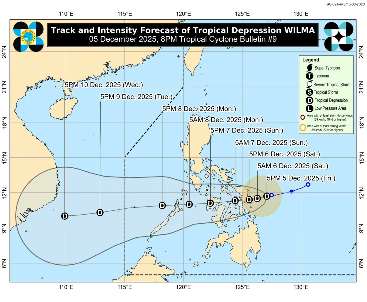
Since Friday night, Dec. 5, “Wilma” has been moving slowly based on the tropical cyclone bulletins issued by PAGASA.
At 8 p.m. on Dec. 5, TD Wilma was located 170 km east of Borongan City.
(PAGASA)
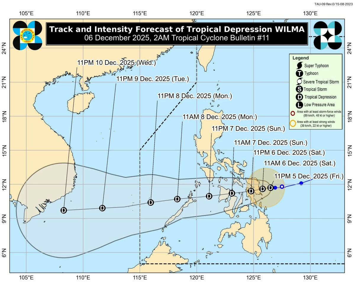
By 11 p.m., PAGASA said “Wilma” had moved closer, at 135 km east of the same area.

(PAGASA)
At 2 a.m. on Saturday, Dec. 6, “Wilma” was 75 km east of Borongan City.
(PAGASA)
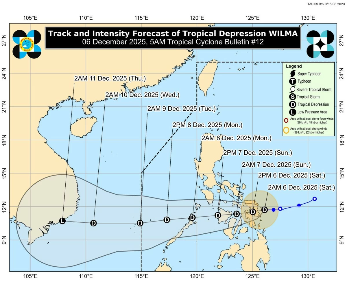
At 5 a.m., PAGASA reported that its center remained 70 km east of Borongan City, moving westward at 15 km/h.
(PAGASA)
Based on its latest advisory issued at 8 a.m., “Wilma” again slowed down while remaining 70 km east of Borongan.
Signal No. 1 up in multiple provinces
In its latest bulletin, PAGASA said Tropical Cyclone Wind Signal (TCWS) No. 1 remains hoisted over wide areas of Luzon, Visayas, and Mindanao, where strong winds (39–61 km/h) and minimal to minor impacts are expected within 36 hours.
Luzon – Sorsogon, Masbate (including Ticao and Burias Islands), Romblon, the southern portion of Oriental Mindoro (Bulalacao, Mansalay, Roxas, Bongabong), the southern portion of Occidental Mindoro (Magsaysay, San Jose, Rizal, Calintaan), and the northernmost portion of Palawan (Araceli, Dumaran, El Nido, Taytay), including the Cuyo, Calamian, and Cagayancillo Islands.
Visayas – Northern Samar, Eastern Samar, Samar, Biliran, Leyte, Southern Leyte, Cebu (including Bantayan and Camotes Islands), Bohol, Negros Occidental, Siquijor, the northern and central portions of Negros Oriental (City of Guihulngan, Canlaon City, Vallehermoso, La Libertad, Jimalalud, Tayasan, Ayungon, Bindoy, Manjuyod, Bais City, Pamplona, City of Tanjay, Amlan, San Jose, Dumaguete City, Valencia, Sibulan, Bacong, Mabinay, City of Bayawan, Basay), Guimaras, Iloilo, Capiz, Aklan, and Antique.
Mindanao – Surigao del Norte (including Siargao and Bucas Grande Islands), Dinagat Islands, the northern portion of Surigao del Sur (Carrascal, Cantilan, Madrid, Carmen, Lanuza), the northern portion of Agusan del Norte (Kitcharao, Jabonga, Santiago, Tubay, City of Cabadbaran, Remedios T. Romualdez, Magallanes), and Camiguin.
PAGASA warned that winds may be slightly stronger in upland and coastal areas directly exposed to the prevailing wind flow.
Monsoon-enhanced winds to affect large areas
Aside from TD Wilma’s circulation, PAGASA said the northeast monsoon (amihan) will bring strong to gale-force gusts today through Monday in areas not under wind signals: Dec. 6 – most of Luzon, Visayas, Zamboanga Peninsula; Dec. 7 – same affected areas; and Dec. 8 – most of Luzon, Eastern and Western Visayas.
Heavy rainfall still expected
PAGASA advised the public to monitor rainfall alerts associated with “Wilma” and the shear line.
Heavy rain may cause flooding, flash floods, and landslides, especially in hazard-prone areas, the state weather bureau said.
A Gale Warning also remains in effect over the eastern seaboards of Luzon and Visayas, where waves may reach up to 5.5 meters:
- Very Rough Seas (up to 5.5 m): Northern and eastern seaboards of Catanduanes; eastern seaboards of Albay and Sorsogon; and northern seaboard of Northern Samar.
- Up to 5.0 m: Mainland Cagayan, Isabela, Aurora, Polillo Islands, Camarines Norte and Sur, and the remaining seaboards of Northern Samar.
- Up to 4.5 m: Batanes, Babuyan Islands, and Eastern Samar.
- Rough Seas (4.0–3.0 m): Ilocos Norte, Surigao del Sur, Kalayaan Islands, and Davao Oriental.
- Moderate to Rough Seas (2.5–2.0 m): Zambales, Bataan, Batangas, Palawan, Cuyo Islands, Antique, Negros Occidental, Oriental Mindoro, Negros Oriental, Davao Occidental, Romblon, Aklan, Quezon, Camarines Sur, Marinduque, Masbate (including Burias), and Zamboanga del Norte.
PAGASA strongly warned all mariners, especially operators of small boats and motorbancas, to avoid sea travel.
Landfall expected on Dec. 6
PAGASA said “Wilma” is expected to make its initial landfall over Eastern Visayas on Dec. 6; traverse the Visayas region tonight until Dec. 7; emerge over the Sulu Sea and pass near or over northern Palawan by the morning of Dec. 8; and potentially intensify once it reaches the West Philippine Sea.
PAGASA emphasized that heavy rains and strong winds may affect areas outside the forecast cone, and that the track could still shift within the uncertainty range.
RELATED STORY: