


Manila Bulletin
 Philippines
National
Tropical Depression Wilma slightly accelerates; landfall possible in Eastern Visayas — PAGASA
Philippines
National
Tropical Depression Wilma slightly accelerates; landfall possible in Eastern Visayas — PAGASA
Philippines
National
Tropical Depression Wilma slightly accelerates; landfall possible in Eastern Visayas — PAGASA
Tropical Depression Wilma slightly accelerates; landfall possible in Eastern Visayas — PAGASA
Published Dec 5, 2025 06:07 am


Tropical Depression Wilma approaches Eastern Visayas on December 5, 2025 --- prompting PAGASA to maintain Signal No. 1 in multiple regions and warn of heavy rains, strong winds, and very rough seas. (PAGASA)
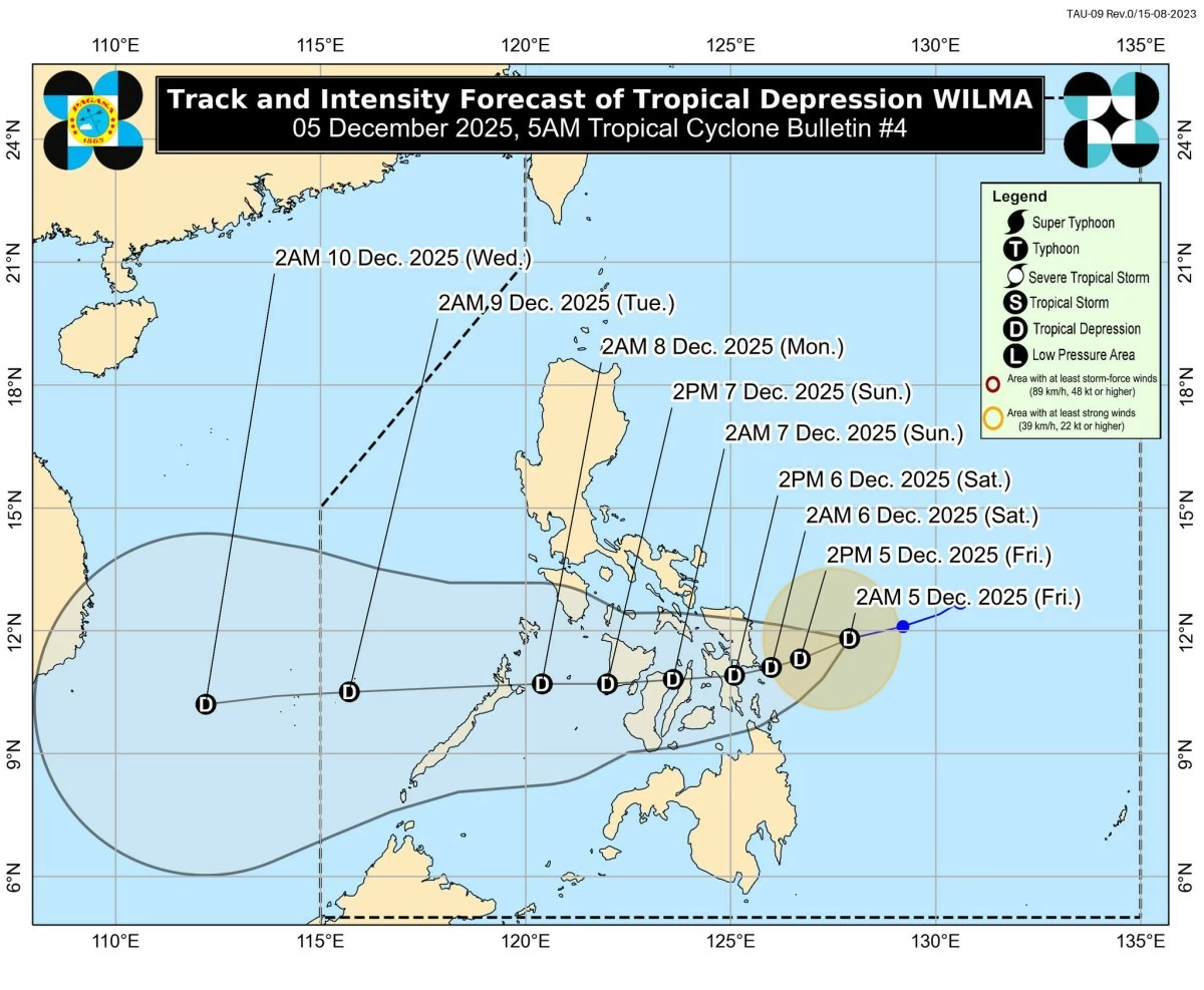
Tropical Depression Wilma slightly accelerated early Friday, December 5, as it continued to move west-southwestward over the Philippine Sea.
In its 5 a.m. tropical cyclone advisory, the Philippine Atmospheric, Geophysical and Astronomical Services Administration (PAGASA) said TD Wilma’s acceleration prompted the state weather bureau to maintain Tropical Cyclone Wind Signal (TCWS) No. 1 over multiple areas in Luzon, Visayas, and Mindanao.
PAGASA said the center of "Wilma" was last located 245 km east of Borongan City, Eastern Samar. It packs maximum sustained winds of 45 km/h and gusts of up to 55 km/h, with strong winds extending outward up to 220 km from the center. The storm is moving west-southwest at 20 km/h.
Areas under Signal No. 1
Signal No. 1 remains raised over provinces in Southern Luzon, Eastern and Central Visayas, Western Visayas, and Northern Mindanao, where minimal to minor impacts from strong winds are expected within 36 hours.
Luzon – The southern portion of mainland Masbate (Cataingan, Pio V. Corpuz, Esperanza, Placer, Cawayan, Palanas, Dimasalang)
Visayas – Northern Samar, Eastern Samar, Samar, Biliran, Leyte, Southern Leyte; the northern and central portions of Cebu (Daanbantayan, Medellin, City of Bogo, San Remigio, Tabogon, Borbon, Tabuelan, Tuburan, Sogod, Catmon, Asturias, Carmen, Danao City, Balamban, Compostela, Liloan, Consolacion, Cebu City, Mandaue City, Cordova, Lapu-Lapu City, Toledo City, Pinamungahan, San Fernando, City of Naga, Minglanilla, City of Talisay, Aloguinsan, City of Carcar, Sibonga, Barili, Alcantara, Ronda, Dumanjug, Argao, Moalboal, Badian, Dalaguete, Alcoy), including Bantayan and Camotes Islands; Bohol; the northern and eastern portions of Negros Occidental (Sagay City, City of Escalante, Toboso, Calatrava, Enrique B. Magalona, City of Victorias, Manapla, Cadiz City, Bacolod City, City of Talisay, Silay City, Salvador Benedicto, San Carlos City, Murcia, Bago City, La Carlota City, La Castellana, Moises Padilla); the northern portion of Negros Oriental (City of Guihulngan, Canlaon City, Vallehermoso, La Libertad); the eastern portion of Iloilo (San Dionisio, Estancia, Batad, Carles, Concepcion, Ajuy, Sara, Balasan, Lemery, Barotac Viejo, San Rafael); and the eastern portion of Capiz (Pilar, President Roxas)
Mindanao – Surigao del Norte, including Siargao and Bucas Grande Islands; Dinagat Islands; the northern portion of Surigao del Sur (Carrascal, Cantilan, Madrid, Carmen, Lanuza); the northern portion of Agusan del Norte (Kitcharao, Jabonga, Santiago, Tubay, City of Cabadbaran, Remedios T. Romualdez, Magallanes); and Camiguin
PAGASA warned that local winds may be stronger in coastal and upland areas, while sheltered areas may experience lighter winds.
Heavy rain, shear line to worsen weather conditions
PAGASA said heavy rainfall is expected today due to the combined effects of Tropical Depression "Wilma" and the shear line.
The northeast monsoon (amihan) will also bring strong to gale-force gusts today over most of Luzon and Visayas, expanding to Mindanao by the weekend, PAGASA added.
Very rough seas; sea travel remains risky
PAGASA said a Gale Warning remains hoisted over the northern and eastern seaboards of Luzon and Visayas, with waves reaching up to 5.5 meters in some areas.
Mariners were warned that sea travel is risky for all vessels in areas with very rough seas.
Small boats, motorbancas, and inexperienced operators should avoid venturing out to sea even in areas with moderate to rough conditions.
Possible landfall in Eastern Visayas tonight or Friday morning
"Wilma" is expected to continue moving west-southwestward until Friday before shifting westward.
PAGASA said the cyclone may make landfall or pass very close to Eastern Visayas or Dinagat Islands between tonight and early Friday.
The system will then cross the Visayas until Sunday (December 7) and re-emerge over the Sulu Sea, possibly moving over northern Palawan by Monday morning.
“Wilma will slightly intensify before landfall but will likely remain as a tropical depression throughout the forecast period,” PAGASA said, adding that further strengthening is possible once it moves over the West Philippine Sea.
RELATED STORY: