


Manila Bulletin
 Philippines
National
PAGASA: 'Wilma' maintains strength; rains to intensify over Visayas, Mindanao
Philippines
National
PAGASA: 'Wilma' maintains strength; rains to intensify over Visayas, Mindanao
Philippines
National
PAGASA: 'Wilma' maintains strength; rains to intensify over Visayas, Mindanao
PAGASA: 'Wilma' maintains strength; rains to intensify over Visayas, Mindanao
Oher weather systems to bring widespread rains ahead of TD Wilma's possible landfall tonight or Saturday morning
Published Dec 5, 2025 10:17 am


Cloud bands from Tropical Depression Wilma extend over parts of Visayas and Mindanao on December 5, 2025, as the system maintains its strength while moving southwestward over the Philippine Sea. (PAGASA)
Tropical Depression Wilma maintained its strength on Friday morning, December 5, as it continued moving southwestward over the Philippine Sea, bringing rains and strong winds across large parts of the country, according to the Philippine Atmospheric, Geophysical and Astronomical Services Administration (PAGASA).
In a press briefing, PAGASA weather specialist Leanne Loreto said Wilma has not yet made landfall, but its cloud bands are already affecting a wide area.
“Base sa ating latest satellite imagery, yung bagyong Wilma ay nandito pa din sa may Philippine Sea (Based on our latest satellite imagery, Wilma is still over the Philippine Sea),” Loreto said.
“Hindi pa ito nagla-landfall pero nag-e-extend na ang kanyang mga kaulapan sa malaking bahagi ng Visayas, maging dito sa Zamboanga Peninsula, Northern Mindanao at Caraga (Although the storm has yet to make landfall, its cloud bands have already spread across large parts of the Visayas, reaching the Zamboanga Peninsula, Northern Mindanao, and Caraga),” she added.
Aside from Wilma, Loreto said the shear line is also expected to bring rains over the Bicol Region and most of MIMAROPA. Meanwhile, the eastern section of Luzon may experience intermittent or burst-type rainfall.
Loreto stressed that multiple weather systems will trigger rains even in areas not directly affected by the tropical depression.
“May mga weather systems na magdadala ng pag-ulan kahit hindi pa tayo apektado ng bagyong Wilma (Other weather systems are expected to bring rain even before Wilma directly affects the country),” she explained.
Signal No. 1 up over multiple areas as ‘Wilma’ maintains strength
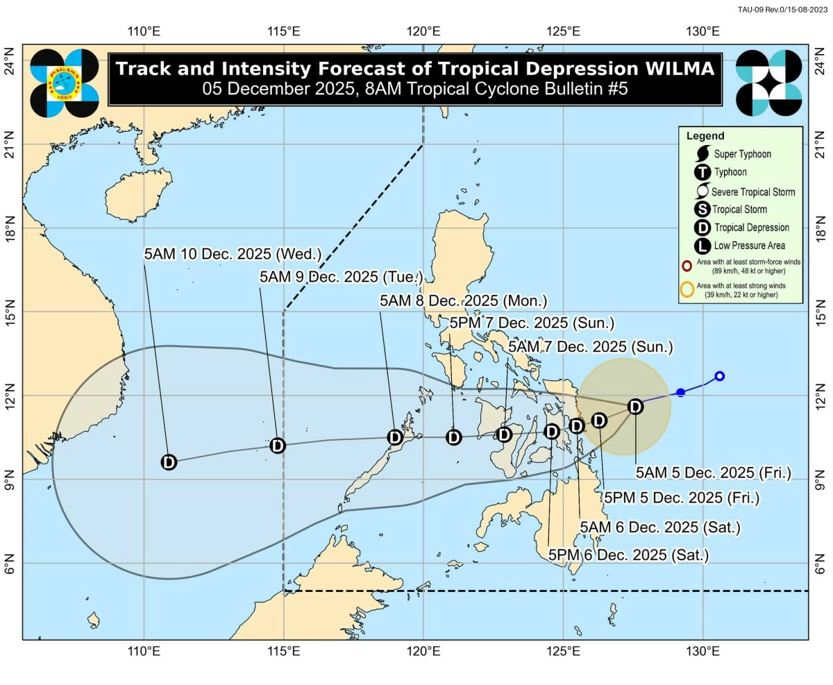
In its 8 a.m. tropical cyclone bulletin, PAGASA said the center of Wilma was located 235 km east of Borongan City, Eastern Samar, packing maximum sustained winds of 45 km/h and gusts of up to 55 km/h.
It continues to move southwestward at 15 km/h. Strong winds extend outward up to 220 km from the center.
Tropical Cyclone Wind Signal (TCWS) No. 1 remains in effect over:
Luzon – The southern portion of mainland Masbate (Cataingan, Pio V. Corpuz, Esperanza, Placer, Cawayan, Palanas, Dimasalang, Uson)
Visayas – Northern Samar, Eastern Samar, Samar, Biliran, Leyte, Southern Leyte, Cebu including Bantayan and Camotes Islands, Bohol, the northern and central portions of Negros Occidental (Sagay City, City of Escalante, Toboso, Calatrava, Enrique B. Magalona, City of Victorias, Manapla, Cadiz City, Bacolod City, City of Talisay, Silay City, Salvador Benedicto, San Carlos City, Murcia, Bago City, La Carlota City, La Castellana, Moises Padilla, Valladolid, Pulupandan, San Enrique, Pontevedra, Hinigaran, Isabela, Binalbagan, City of Himamaylan, City of Kabankalan), Siquijor, the northern and central portions of Negros Oriental (City of Guihulngan, Canlaon City, Vallehermoso, La Libertad, Jimalalud, Tayasan, Ayungon, Bindoy, Manjuyod, Bais City, Pamplona, City of Tanjay, Amlan, San Jose, Dumaguete City, Valencia, Sibulan, Bacong, Mabinay), the eastern portion of Iloilo (San Dionisio, Estancia, Batad, Carles, Concepcion, Ajuy, Sara, Balasan, Lemery, Barotac Viejo, San Rafael, City of Passi, San Enrique, Anilao, Banate, Dingle, Barotac Nuevo, Mina, Pototan, New Lucena, Santa Barbara, Pavia, Iloilo City, Leganes, Zarraga, Dumangas, Dueñas), the eastern portion of Capiz (Pilar, President Roxas, Panay, Pontevedra, Ma-Ayon, Cuartero, Dumarao, Dao, Panitan, Roxas City), and Guimaras
Mindanao – Surigao del Norte, including Siargao and Bucas Grande Islands; Dinagat Islands; the northern portion of Surigao del Sur (Carrascal, Cantilan, Madrid, Carmen, Lanuza); the northern portion of Agusan del Norte (Kitcharao, Jabonga, Santiago, Tubay, City of Cabadbaran, Remedios T. Romualdez, Magallanes); and Camiguin
PAGASA warned that areas under TCWS No. 1 may experience minimal to minor impacts from strong winds.
Heavy rains, strong winds, and rough seas expected
Loreto said the combined effects of Wilma, the shear line, and the northeast monsoon will enhance rainfall and winds over Luzon, Visayas, and Mindanao.
Wind gusts from the northeast monsoon may reach strong to gale-force intensity, especially in coastal and upland areas of Luzon and the Visayas today, expanding to the Zamboanga Peninsula and Misamis Occidental by the weekend.
A Gale Warning also remains in effect over several northern and eastern seaboards. Seas may reach up to 5.5 meters, making sea travel risky or unsafe for all vessels, especially small boats and motorbancas. PAGASA advised mariners to remain in port or seek shelter until conditions improve.
Landfall possible tonight or early Saturday
Based on PAGASA’s forecast track, Wilma may make initial landfall in Eastern Visayas or Dinagat Islands between tonight and early Saturday.
It will then traverse the Visayas until Sunday before emerging over the Sulu Sea and possibly passing over northern Palawan by Monday morning.
The tropical depression is expected to slightly intensify before landfall but is likely to remain a tropical depression through the weekend.
Further strengthening is possible once it moves into the West Philippine Sea, PAGASA said.
The state weather bureau urged the public and local governments to prepare for potential flooding, landslides, and strong winds. Communities in high- to very-high-risk areas were also advised to follow evacuation and safety instructions from local officials.
RELATED STORY: