


'Wilma' maintains strength; over 10 areas under Signal No. 1
PAGASA warns of strong winds and rough seas in affected areas
Published Dec 4, 2025 11:40 pm


Tropical Depression Wilma continues west-southwestward over the Philippine Sea with strong winds and rough seas. PAGASA issues TCWS No. 1 warnings for Luzon, Visayas, and Mindanao. (PAGASA)
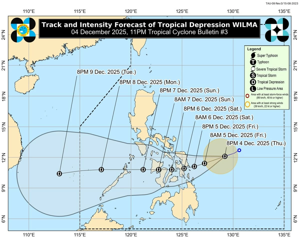
Tropical Depression Wilma continues to move west-southwestward over the Philippine Sea, maintaining maximum sustained winds of 45 km/h with gusts of up to 55 km/h, the Philippine Atmospheric, Geophysical and Astronomical Services Administration (PAGASA) reported on Thursday, December 4.
In its 11 p.m. tropical cyclone bulletin, PAGASA said that as of 10 p.m., the center of “Wilma” was located approximately 480 kilometers east of Catarman, Northern Samar, or 390 kilometers east of Borongan City, Eastern Samar.
The tropical depression is moving at a speed of 15 km/h, with strong winds extending up to 220 km from its center.
Tropical Cyclone Wind Signals in effect
PAGASA has raised Tropical Cyclone Wind Signal (TCWS) No. 1 for several areas across Luzon, Visayas, and Mindanao, indicating minimal to minor threats to life and property from strong winds.
Luzon: Southern Masbate (Cataingan, Pio V. Corpuz, Esperanza, Placer)
Visayas: Northern Samar, Eastern Samar, Samar, Biliran, Leyte, Southern Leyte, northern and central Cebu (including Daanbantayan, Bogo City, Cebu City, Mandaue City, Lapu-Lapu City), Bantayan and Camotes Islands, Bohol, and eastern Negros Occidental (Sagay City, Escalante City, Calatrava, Toboso)
Mindanao: Surigao del Norte (including Siargao and Bucas Grande Islands), Dinagat Islands, northern Surigao del Sur (Carrascal, Cantilan, Madrid, Carmen), and northern Agusan del Norte (Kitcharao, Jabonga, Santiago, Tubay, Cabadbaran City)
In addition to the tropical depression, PAGASA said the northeast monsoon (amihan) will bring strong to gale-force winds over various regions in Luzon and Visayas until Saturday, December 6.
Heavy rainfall and coastal hazards
PAGASA warned of potential heavy rainfall due to “Wilma” and a shear line.
Coastal waters are experiencing very rough to rough seas, with waves reaching up to 5.5 meters in the northern and eastern seaboards of Catanduanes and Northern Samar.
Mariners, particularly those operating small vessels, are urged to seek safe harbor immediately, PAGASA added.
Forecast and preparedness
PAGASA said “Wilma” is expected to continue moving west-southwestward until Saturday before turning westward.
Initial landfall may occur in Eastern Visayas or the Dinagat Islands between Friday evening, December 5, and Saturday morning, December 6.
The tropical depression is forecast to traverse Visayas and eventually reach northern Palawan by Sunday evening to Monday morning.
“Wilma will slightly intensify before landfall but will likely remain a tropical depression throughout the forecast period,” PAGASA said. “Further intensification is possible once it emerges over the West Philippine Sea.”
Authorities and residents in high-risk areas are advised to follow evacuation orders and safety instructions issued by local government units.
RELATED STORY: