


LPA, to be named 'Wilma', to enter PAR on December 3 — PAGASA
'Amihan', ITCZ to bring rains across parts of the Philippines; rainy weekend expected
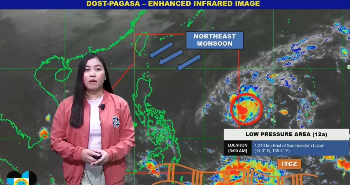
Published Dec 3, 2025 08:32 am


PAGASA monitors the low-pressure area expected to enter the Philippine Area of Responsibility on December 3, 2025 which may intensify into Tropical Cyclone Wilma, as the 'amihan' and ITCZ bring rains across parts of the Philippines. (PAGASA / FB)
A low-pressure area (LPA), which will be locally named “Wilma” once it develops into a tropical cyclone, is expected to enter the Philippine Area of Responsibility (PAR) on Wednesday, December 3, according to the Philippine Atmospheric, Geophysical and Astronomical Services Administration (PAGASA).
In its latest forecast, PAGASA weather specialist Loriedin De la Cruz-Galicia said the weather bureau is monitoring an LPA located 1,201 kilometers east of southeastern Luzon, which is still outside the country’s area of responsibility.
“Ngayon, nasa labas pa ito ng PAR at inaasahan nating papasok ito sa loob ng ating area of responsibility ngayong araw din. Nanatiling mataas ang tsansa na mabuo ito bilang isang bagyo within the next 24 hours (The LPA is still outside PAR but is expected to enter our area of responsibility today. There remains a high chance that it will develop into a tropical cyclone within the next 24 hours),” Galicia said.
“So kung ito ay pumasok ng PAR at maging bagyo, bibigyan po natin ito ng local name na si bagyong ‘Wilma’ (If it becomes a storm upon entering PAR, it will be named ‘Wilma’),” she added.
Galicia said initial forecasts indicate a high probability of landfall in Eastern Visayas or the Caraga region by Saturday or Sunday (December 5 or 6).
“Sa initial nating datos at analysis, nananatiling mataas ang tsansa ng landfall scenario dito sa Eastern Visayas o kaya naman sa Caraga region by Saturday or Sunday (Based on our initial data and analysis, there remains a high probability of a landfall scenario in Eastern Visayas or Caraga by Saturday or Sunday),” she explained.
The weather disturbance is also expected to affect large areas of the Visayas and parts of Mindanao over the weekend.
PAGASA may raise Tropical Cyclone Wind Signal (TCWS) No. 1 as early as Thursday, December 4, for Eastern Visayas or Caraga if the system intensifies.
Weather systems to bring rains
Meanwhile, PAGASA said large parts of the Philippines will experience cooler and rainy weather on December 3 as the northeast monsoon or “amihan” and the Intertropical Convergence Zone (ITCZ) continue to affect the country.
Galicia said the “amihan” is bringing cloudy and cold conditions over much of Northern Luzon, while the ITCZ continues to influence the southern portion of Mindanao.
“Magiging maulan at malamig ang kondisyon ng panahon sa malaking bahagi ng Northern Luzon sa araw na ito dahil muling umiiral po doon ang amihan o northeast monsoon (Rainy and cool weather conditions will prevail over much of Northern Luzon today due to the northeast monsoon),” she said.
She added that these weather systems, along with localized thunderstorms, may bring rain across large areas of the country throughout the day.
“Itong dalawang weather systems na ito—ang ITCZ at northeast monsoon—kasama na ang localized thunderstorms, ay pwedeng magdulot ng pag-ulan sa malaking bahagi ng ating bansa (These two weather systems—the ITCZ and the northeast monsoon—together with localized thunderstorms, may bring rainfall over large parts of the country),” Galicia added.
Weather forecast
Based on PAGASA’s latest forecast, Metro Manila and the rest of the country will experience partly cloudy to cloudy skies with isolated rain showers or thunderstorms caused by localized thunderstorms, which may lead to flash floods or landslides during severe conditions.
Basilan, Sulu, and Tawi-Tawi will have cloudy skies with scattered rains and thunderstorms due to the ITCZ, which may trigger flash floods or landslides.
Cagayan Valley, Ilocos Norte, Apayao, Kalinga, and Aurora will experience cloudy skies with rains brought by the northeast monsoon, with possible flooding in low-lying areas.
The rest of the Ilocos Region, Cordillera Administrative Region, and Central Luzon will have partly cloudy to cloudy skies with isolated light rains and no significant impact.
PAGASA urged the public to stay updated on weather advisories, especially in areas that may be affected once the LPA enters PAR and potentially develops into “Wilma.”