ADVERTISEMENT

'Uwan' to bring heavy rains in next 3 days, PAGASA warns

Published Nov 9, 2025 08:54 am
PAGASA
PAGASA
The Philippine Atmospheric, Geophysical and Astronomical Services Administration (PAGASA) on Sunday, Nov. 9, warned of heavy to intense rainfall over parts of Luzon until Tuesday, Nov. 11, as Super Typhoon Uwan (Fung-wong) is expected to cross the country.
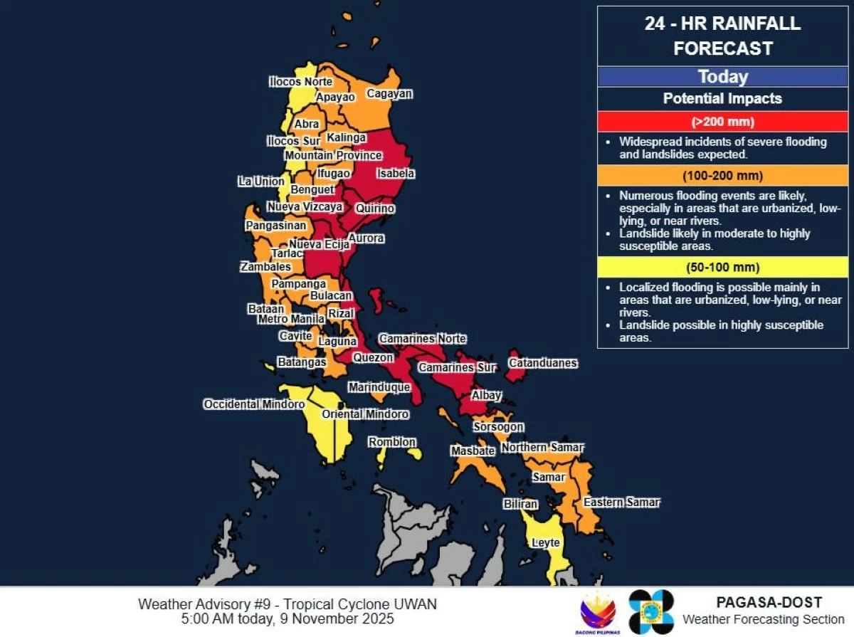
On Sunday, PAGASA said intense to torrential rainfall (more than 200 millimeters) is expected in Isabela, Quirino, Nueva Vizcaya, Aurora, Nueva Ecija, Quezon, Camarines Norte, Camarines Sur, Catanduanes, and Albay
Meanwhile, heavy to intense rainfall (between 100 and 200 millimeters) may affect Pangasinan, Cagayan, Apayao, Abra, Kalinga, Mountain Province, Ifugao, Benguet, Zambales, Tarlac, Pampanga, Bataan, Bulacan, Metro Manila, Cavite, Batangas, Laguna, Rizal, and Marinduque.
Moderate to heavy rainfall (50 to 100 millimeters) may be experienced in Ilocos Norte, Ilocos Sur, La Union, Occidental Mindoro, Oriental Mindoro, and Romblon.
On Monday, Nov. 10, over 200 millimeters of rainfall is expected in Kalinga, Mountain Province, Ifugao, Benguet, Ilocos Sur, La Union, Pangasinan, Tarlac, and Zambales.
Meanwhile, 100 to 200 millimeters of rain may affect Ilocos Norte, Apayao, Abra, Cagayan, Isabela, Quirino, Nueva Vizcaya, Bataan, Aurora, Nueva Ecija, Pampanga, and Bulacan.
Moderate to heavy rainfall is expected in Batanes, Metro Manila, Cavite, Laguna, Batangas, Rizal, Quezon, Occidental Mindoro, Oriental Mindoro, and Marinduque.
On Tuesday, Nov. 11, moderate to heavy rainfall millimeters may continue in Ilocos Sur, La Union, Pangasinan, and Benguet.
PAGASA said rainfall may be higher in mountainous and elevated areas and warned that impacts in areas with previous heavy rainfall may worsen.
Local disaster risk reduction and management offices have been advised to take all necessary measures to protect life and property.
According to PAGASA, Uwan is expected to continue moving west-northwestward over the next 24 hours.
It may pass close to Catanduanes this morning before making landfall over Aurora tonight or early Monday morning, Nov. 10. A direct hit over Catanduanes remains possible.
Uwan may make landfall at or near its peak intensity.
The cyclone will weaken as it crosses Northern Luzon’s mountainous terrain but is expected to remain a typhoon throughout its passage.
After landfall, Uwan will traverse Northern Luzon and may emerge over Lingayen Gulf or the coastal waters of Pangasinan or La Union by tomorrow morning.
READ MORE:
mb.com.ph/2025/11/09/pagasa-raises-signal-no-5-as-uwan-intensifies-into-super-typhoon

Related Tags

SUPER TYPHOON UWAN PAGASA FUNG-WONG SIGNAL NO. 5
ADVERTISEMENT
.most-popular .layout-ratio{ padding-bottom: 79.13%; } @media (min-width: 768px) and (max-width: 1024px) { .widget-title { font-size: 15px !important; } }

{{ articles_filter_1561_widget.title }}

.most-popular .layout-ratio{ padding-bottom: 79.13%; } @media (min-width: 768px) and (max-width: 1024px) { .widget-title { font-size: 15px !important; } }

{{ articles_filter_1562_widget.title }}

.most-popular .layout-ratio{ padding-bottom: 79.13%; } @media (min-width: 768px) and (max-width: 1024px) { .widget-title { font-size: 15px !important; } }

{{ articles_filter_1563_widget.title }}

{{ articles_filter_1564_widget.title }}

.mb-article-details { position: relative; } .mb-article-details .article-body-preview, .mb-article-details .article-body-summary{ font-size: 17px; line-height: 30px; font-family: "Libre Caslon Text", serif; color: #000; } .mb-article-details .article-body-preview iframe , .mb-article-details .article-body-summary iframe{ width: 100%; margin: auto; } .read-more-background { background: linear-gradient(180deg, color(display-p3 1.000 1.000 1.000 / 0) 13.75%, color(display-p3 1.000 1.000 1.000 / 0.8) 30.79%, color(display-p3 1.000 1.000 1.000) 72.5%); position: absolute; height: 200px; width: 100%; bottom: 0; display: flex; justify-content: center; align-items: center; padding: 0; } .read-more-background a{ color: #000; } .read-more-btn { padding: 17px 45px; font-family: Inter; font-weight: 700; font-size: 18px; line-height: 16px; text-align: center; vertical-align: middle; border: 1px solid black; background-color: white; } .hidden { display: none; }
function initializeAllSwipers() { // Get all hidden inputs with cms_article_id document.querySelectorAll('[id^="cms_article_id_"]').forEach(function (input) { const cmsArticleId = input.value; const articleSelector = '#article-' + cmsArticleId + ' .body_images'; const swiperElement = document.querySelector(articleSelector); if (swiperElement && !swiperElement.classList.contains('swiper-initialized')) { new Swiper(articleSelector, { loop: true, pagination: false, navigation: { nextEl: '#article-' + cmsArticleId + ' .swiper-button-next', prevEl: '#article-' + cmsArticleId + ' .swiper-button-prev', }, }); } }); } setTimeout(initializeAllSwipers, 3000); const intersectionObserver = new IntersectionObserver( (entries) => { entries.forEach((entry) => { if (entry.isIntersecting) { const newUrl = entry.target.getAttribute("data-url"); if (newUrl) { history.pushState(null, null, newUrl); let article = entry.target; // Extract metadata const author = article.querySelector('.author-section').textContent.replace('By', '').trim(); const section = article.querySelector('.section-info ').textContent.replace(' ', ' '); const title = article.querySelector('.article-title h1').textContent; // Parse URL for Chartbeat path format const parsedUrl = new URL(newUrl, window.location.origin); const cleanUrl = parsedUrl.host + parsedUrl.pathname; // Update Chartbeat configuration if (typeof window._sf_async_config !== 'undefined') { window._sf_async_config.path = cleanUrl; window._sf_async_config.sections = section; window._sf_async_config.authors = author; } // Track virtual page view with Chartbeat if (typeof pSUPERFLY !== 'undefined' && typeof pSUPERFLY.virtualPage === 'function') { try { pSUPERFLY.virtualPage({ path: cleanUrl, title: title, sections: section, authors: author }); } catch (error) { console.error('ping error', error); } } // Optional: Update document title if (title && title !== document.title) { document.title = title; } } } }); }, { threshold: 0.1 } ); function showArticleBody(button) { const article = button.closest("article"); const summary = article.querySelector(".article-body-summary"); const body = article.querySelector(".article-body-preview"); const readMoreSection = article.querySelector(".read-more-background"); // Hide summary and read-more section summary.style.display = "none"; readMoreSection.style.display = "none"; // Show the full article body body.classList.remove("hidden"); } document.addEventListener("DOMContentLoaded", () => { let loadCount = 0; // Track how many times articles are loaded const offset = [1, 2, 3, 4, 5, 6, 7, 8, 9, 10]; // Offset values const currentUrl = window.location.pathname.substring(1); let isLoading = false; // Prevent multiple calls if (!currentUrl) { console.log("Current URL is invalid."); return; } const sentinel = document.getElementById("load-more-sentinel"); if (!sentinel) { console.log("Sentinel element not found."); return; } function isSentinelVisible() { const rect = sentinel.getBoundingClientRect(); return ( rect.top < window.innerHeight && rect.bottom >= 0 ); } function onScroll() { if (isLoading) return; if (isSentinelVisible()) { if (loadCount >= offset.length) { console.log("Maximum load attempts reached."); window.removeEventListener("scroll", onScroll); return; } isLoading = true; const currentOffset = offset[loadCount]; window.loadMoreItems().then(() => { let article = document.querySelector('#widget_1690 > div:nth-last-of-type(2) article'); intersectionObserver.observe(article) loadCount++; }).catch(error => { console.error("Error loading more items:", error); }).finally(() => { isLoading = false; }); } } window.addEventListener("scroll", onScroll); });

Sign up by email to receive news.