


Manila Bulletin
 Philippines
National
PAGASA raises Signal No. 5 as 'Uwan' intensifies into super typhoon
Philippines
National
PAGASA raises Signal No. 5 as 'Uwan' intensifies into super typhoon
Philippines
National
PAGASA raises Signal No. 5 as 'Uwan' intensifies into super typhoon
PAGASA raises Signal No. 5 as 'Uwan' intensifies into super typhoon
Life-threatening winds, rains now affecting parts of Bicol
Published Nov 9, 2025 08:32 am


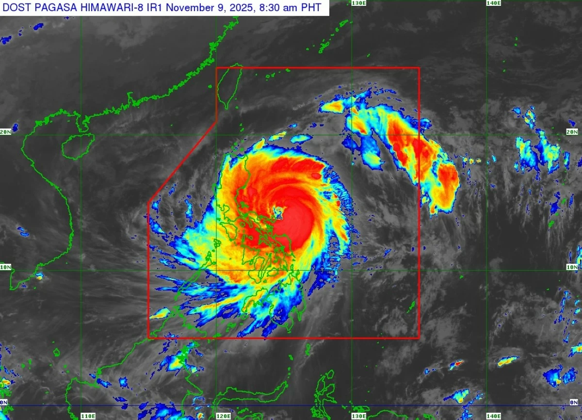
Satellite image of Super Typhoon Uwan (Fung-wong) (Courtesy of PAGASA)
The Philippine Atmospheric, Geophysical and Astronomical Services Administration (PAGASA) on Sunday morning, Nov. 9, raised Tropical Cyclone Wind Signal No. 5 over parts of Bicol Region and Quezon province as Typhoon Uwan (international name: Fung-wong) intensified into a super typhoon.
As of 7 a.m., the center of the eye of Uwan was located 125 kilometers east-northeast of Virac, Catanduanes.
It was moving west-northwestward at 25 kilometers per hour (kph), packing maximum sustained winds of 185 kph near the center and gustiness of up to 230 kph.
According to PAGASA, Uwan is expected to continue moving west-northwestward over the next 24 hours.
It may pass close to Catanduanes this morning before making landfall over Aurora tonight or early Monday morning, Nov. 10. A direct hit over Catanduanes remains possible.
Uwan may make landfall at or near its peak intensity.
The cyclone will weaken as it crosses Northern Luzon’s mountainous terrain but is expected to remain a typhoon throughout its passage.
After landfall, Uwan will traverse Northern Luzon and may emerge over Lingayen Gulf or the coastal waters of Pangasinan or La Union by tomorrow morning.
PAGASA said Signal No. 5 is now in effect over Polillo Islands, northern portion of Camarines Norte (Daet, Talisay, Paracale, Vinzons, Jose Panganiban, Mercedes, and Basud), eastern portion of Camarines Sur (Siruma, Caramoan, Garchitorena, Tinambac, and Lagonoy), and Catanduanes.
Extreme impacts from typhoon-force winds are possible within these areas.
Signal No. 4 has been raised over the eastern portion of Quezon (Tagkawayan, Calauag, Guinayangan, Perez, Alabat, and Quezon), the rest of Camarines Norte, the rest of Camarines Sur, and the eastern portion of Albay (Rapu-Rapu, Bacacay, Tabaco City, Malilipot, Malinao, Tiwi, and Polangui).
PAGASA said significant to severe impacts from typhoon-force winds are possible within these areas.
Signal No. 3 is hoisted over the southern portion of mainland Cagayan (Tuao, Enrile, Solana, Tuguegarao City, Peñablanca, Iguig, Piat, and Amulung), Isabela, Quirino, Nueva Vizcaya, southern portion of Apayao (Conner), Kalinga, Abra, Mountain Province, Ifugao, Benguet, Ilocos Sur, La Union, Pangasinan, Zambales, Bataan, Tarlac, Pampanga, Nueva Ecija, Bulacan, Aurora, Metro Manila, Cavite, Batangas, Rizal, Laguna, the rest of Quezon, Marinduque, the rest of Albay, Sorsogon, Ticao Island and Burias Island, Northern Samar, northern portion of Eastern Samar (Jipapad, Arteche, San Policarpo, Oras, Dolores, and Maslog), and northern portion of Samar (Calbayog City, Matuguinao, Gandara, Santa Margarita, and San Jose de Buan).
PAGASA said moderate to significant impacts from storm-force winds are possible within these areas.
Signal No. 2 remains hoisted over the rest of Cagayan including Babuyan Islands, the rest of Apayao; Ilocos Norte, Occidental Mindoro including Lubang Islands, Oriental Mindoro; Romblon, the rest of Masbate, the rest of Eastern Samar, the rest of Samar, Biliran, and northern and central portions of Leyte (Leyte, Calubian, San Isidro, Tabango, Capoocan, Carigara, Barugo, San Miguel, Babatngon, Tacloban City, Alangalang, Tunga, Palo, Santa Fe, Pastrana, Matag-Ob, Tolosa, Mayorga, Julita, Dagami, Jaro, Villaba, La Paz, Tabontabon, Tanauan, Ormoc City, Dulag, Burauen, Kananga, Albuera, Palompon, Merida, and Isabel).
Minor to moderate impacts from gale-force winds are possible within these areas.
Signal No. 1 is up over Batanes, Calamian Islands, Cuyo Islands, the rest of Leyte, Southern Leyte, Bohol, northern and central portions of Cebu (Medellin, Daanbantayan, Bogo City, Tabogon, San Remigio, Tabuelan, Borbon, Sogod, Tuburan, Catmon, Carmen, Danao City, Compostela, Liloan, Consolacion, Lapu-Lapu City, Mandaue City, Cordova, Asturias, Cebu City, Talisay City, Toledo City, Minglanilla, Dumanjug, Argao, Sibonga, Barili, Ronda, Moalboal, Badian, Dalaguete, Alcantara, Carcar City, Naga City, San Fernando, Pinamungahan, and Aloguinsan), including Bantayan and Camotes Islands, northern and central portions of Negros Occidental (Escalante City, Toboso, Sagay City, Cadiz City, Calatrava, Manapla, Victorias City, Enrique B. Magalona, Silay City, Talisay City, San Carlos City, Salvador Benedicto, Murcia, Bacolod City, Hinigaran, Himamaylan City, Binalbagan, Isabela, Moises Padilla, La Castellana, Pontevedra, San Enrique, La Carlota City, Bago City, Valladolid, and Pulupandan), northern portion of Negros Oriental (Canlaon City, Jimalalud, La Libertad, Tayasan, Vallehermoso, and Guihulngan City), Guimaras, Iloilo, Capiz, Aklan, Antique, Dinagat Islands, Surigao del Norte, northern portion of Agusan del Norte (Tubay, Santiago, Jabonga, and Kitcharao), and northern portion of Surigao del Sur (Carrascal, Cantilan, Madrid, Carmen, Lanuza, and Cortes).
PAGASA said minimal to minor impacts from strong winds are possible within these areas.
By Tuesday, Nov. 11, Uwan is expected to move northwestward and exit the Philippine Area of Responsibility before turning northeastward.
PAGASA said Uwan may re-enter the northwestern boundary of PAR by Thursday, Nov. 13, cross Taiwan, and exit completely by Friday morning, Nov. 14.