


Manila Bulletin
 Philippines
National
TS Ramil slightly intensifies, nearing Northern Samar; Catanduanes landfall likely — PAGASA
Philippines
National
TS Ramil slightly intensifies, nearing Northern Samar; Catanduanes landfall likely — PAGASA
Philippines
National
TS Ramil slightly intensifies, nearing Northern Samar; Catanduanes landfall likely — PAGASA
TS Ramil slightly intensifies, nearing Northern Samar; Catanduanes landfall likely — PAGASA
Published Oct 18, 2025 12:18 pm
|
Updated Oct 18, 2025 01:27 pm


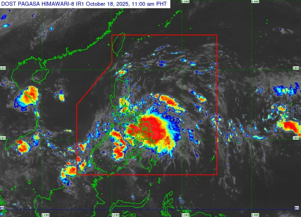
PAGASA said Tropical Storm Ramil slightly intensified as it nears Northern Samar and is expected to make landfall in Catanduanes on Saturday evening, October 18, 2025. (PAGASA)
The Philippine Atmospheric, Geophysical and Astronomical Services Administration (PAGASA) said on Saturday, October 18, that Tropical Storm Ramil (international name: Fengshen) has slightly intensified as it moves closer to the waters off Northern Samar.
In its 11 a.m. tropical cyclone bulletin, PAGASA reported that the center of “Ramil” was located over the coastal waters of Palapag, Northern Samar, as of 10 a.m.
Tropical Storm Ramil is packing maximum sustained winds of 75 km/h near the center, gustiness of up to 90 km/h, and a central pressure of 998 hPa. PAGASA said it is currently moving west-southwestward at 20 km/h.
PAGASA added that “Ramil” is expected to move west-northwestward later today and may make landfall or pass close to Northern Samar by noon or early afternoon before crossing Catanduanes in the evening.
The state weather bureau also noted an increasing possibility of landfall over Albay or Sorsogon based on the storm’s recent movement.
Signal No. 2 up in parts of Luzon, Visayas
PAGASA said Tropical Cyclone Wind Signal (TCWS) No. 2 is currently hoisted over the following areas:
Luzon – The northern portion of Aurora (Casiguran, Dilasag, Dinalungan), Polillo Islands, Camarines Norte, Catanduanes, the northern portion of Camarines Sur (Tinambac, Siruma, Goa, San Jose, Lagonoy, Garchitorena, Caramoan, Presentacion), the extreme eastern portion of Albay (Rapu-Rapu), and the northeastern portion of Sorsogon (Prieto Diaz).
Visayas – The northeastern part of Northern Samar, including Laoang, Palapag, Mapanas, Pambujan, San Roque, Mondragon, and Gamay.
These areas may experience gale-force winds of 62 to 88 km/h within the next 24 hours, posing minor to moderate threats to life and property, PAGASA said.
Meanwhile, Signal No. 1 is in effect over several provinces in Luzon and the Visayas:
Luzon – Cagayan including the Babuyan Islands, Isabela, Quirino, Nueva Vizcaya, Apayao, Abra, Kalinga, Mountain Province, Ifugao, Benguet, Ilocos Norte, Ilocos Sur, La Union, Pangasinan, the rest of Aurora, Nueva Ecija, the eastern portion of Bulacan (Doña Remedios Trinidad, Norzagaray, San Miguel, San Ildefonso, San Rafael, Angat), the eastern portion of Tarlac (Camiling, San Clemente, Santa Ignacia, Paniqui, Moncada, San Manuel, Anao, Ramos, Pura, Victoria, City of Tarlac, La Paz, Concepcion, Gerona), the eastern portion of Pampanga (Magalang, Arayat, Candaba), the northern and eastern portions of Quezon (Tagkawayan, Perez, Alabat, Quezon, Atimonan, Padre Burgos, Unisan, Gumaca, Plaridel, Agdangan, Pagbilao, Mauban, Calauag, Guinayangan, Lopez, Pitogo, Macalelon, General Luna, Catanauan, San Narciso, Buenavista, San Francisco, San Andres, Mulanay, General Nakar, Infanta, Real, Sampaloc), the rest of Camarines Sur, the rest of Albay, the rest of Sorsogon, Burias Island, and Ticao Island.
Visayas – Northern Samar, the northern portion of Eastern Samar (San Policarpo, Arteche, Oras, Dolores, Maslog, Jipapad, Taft, Can-Avid), and the northern portion of Samar (Matuguinao, San Jose de Buan, Calbayog City, Gandara, Santa Margarita, Pagsanghan, San Jorge, Tagapul-An, Almagro, Santo Niño, Tarangnan, Paranas, City of Catbalogan, Jiabong, Motiong).
PAGASA said a warning lead time of 36 hours is in effect, with expected wind speeds ranging from 39 to 61 km/h, posing a minimal to minor threat to life and property.
Heavy rains, strong winds, and storm surge expected
PAGASA warned that heavy rainfall, strong winds, and storm surges are expected over large parts of Luzon and the Visayas, including areas outside TS Ramil’s projected landfall path.
Heavy rains may trigger flooding and landslides in low-lying and mountainous areas, particularly in the Bicol Region, Eastern Visayas, and Southern Luzon.
Strong to gale-force gusts may also affect Cagayan Valley, CALABARZON, Metro Manila, Ilocos Region, Marinduque, Mindoro, and Masbate.
A storm surge of 1.0 to 2.0 meters may occur over coastal areas of Isabela, Aurora, Quezon, Marinduque, Camarines Norte and Sur, Catanduanes, Albay, Sorsogon, Masbate, Romblon, Northern Samar, Eastern Samar, Samar, Ilocos Norte, Ilocos Sur, La Union, Pangasinan, and Zambales, PAGASA added.
Rough to very rough seas in affected coastal areas
PAGASA said a gale warning remains in effect over the eastern seaboard of Southern Luzon.
Sea travel is risky over the seaboards of Isabela, Camarines Norte, Camarines Sur, and Catanduanes, where waves may reach up to 5 meters. Small vessels and motorbancas are strongly advised to remain in port until sea conditions improve.
Forecast track and intensity
PAGASA said “Ramil” is forecast to cross Catanduanes by Saturday evening, move toward Aurora or northern Quezon by Sunday morning or afternoon, traverse the mountainous terrain of Northern Luzon by Sunday night, and exit the Philippine Area of Responsibility (PAR) by Monday morning, October 20.
Intensification into a severe tropical storm before landfall is possible, with potential re-intensification once it moves over the West Philippine Sea, PAGASA added.
The agency urged the public and local disaster risk reduction offices to prepare for possible flooding, landslides, and strong winds. Residents in high-risk areas are advised to follow evacuation orders and stay updated through official advisories.
RELATED STORY: