


Manila Bulletin
 Philippines
National
Seven areas in Luzon, Visayas under Signal No. 2 as 'Ramil' slightly weakens near Northern Samar
Philippines
National
Seven areas in Luzon, Visayas under Signal No. 2 as 'Ramil' slightly weakens near Northern Samar
Philippines
National
Seven areas in Luzon, Visayas under Signal No. 2 as 'Ramil' slightly weakens near Northern Samar
Seven areas in Luzon, Visayas under Signal No. 2 as 'Ramil' slightly weakens near Northern Samar
PAGASA says TS Ramil may make several landfalls from Catanduanes to Aurora this weekend
Published Oct 18, 2025 03:08 pm


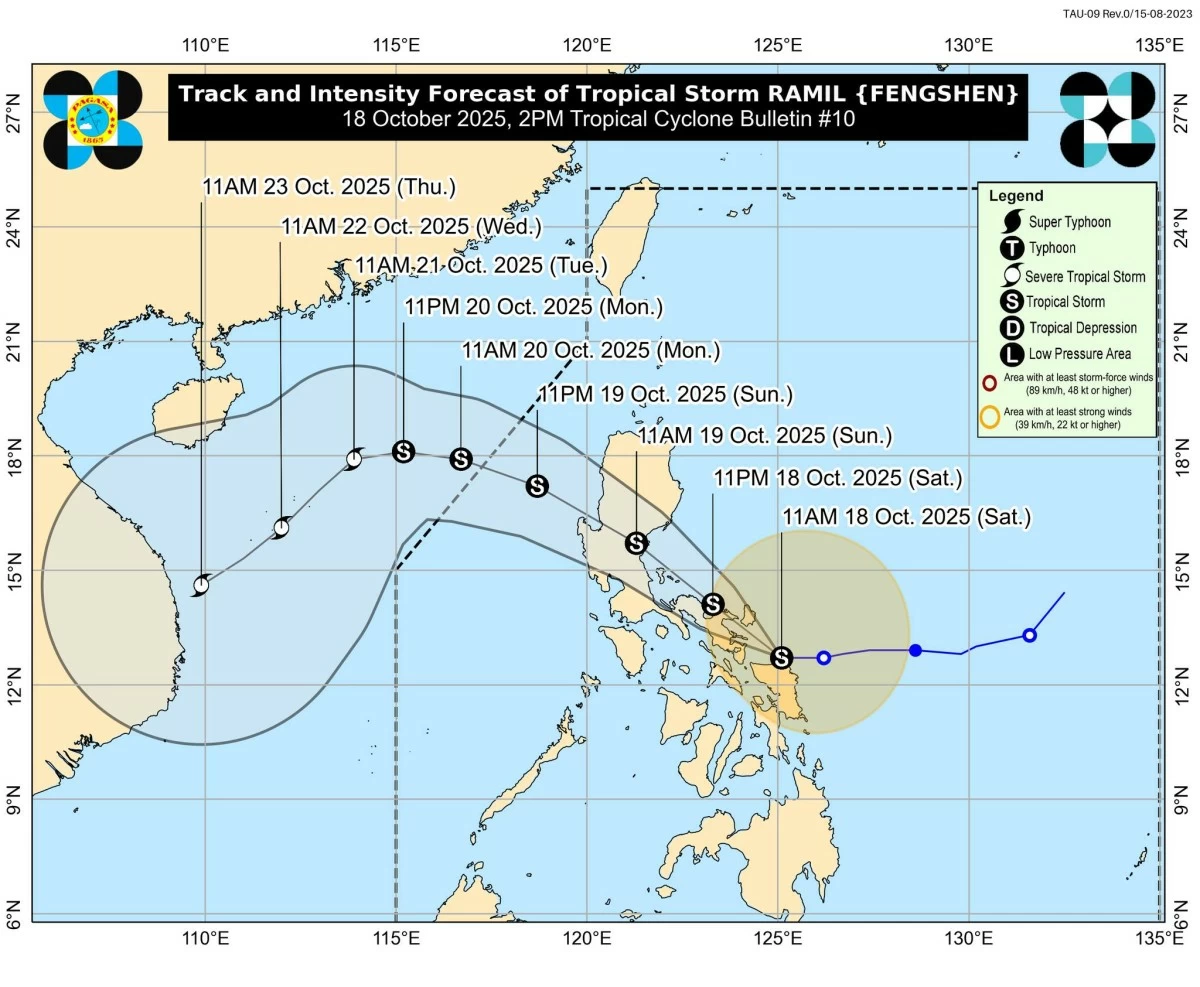
The Philippine Atmospheric, Geophysical and Astronomical Services Administration (PAGASA) said on Saturday, October 18, that seven areas in Luzon and the Visayas remain under Tropical Cyclone Wind Signal (TCWS) No. 2 as Tropical Storm Ramil (international name: Fengshen) slightly weakened while moving near the coastal waters of Northern Samar.
Tropical Storm Ramil weakens near Northern Samar; seven areas in Luzon and Visayas under Signal No. 2 as PAGASA warns of heavy rains and strong winds. (PAGASA)
In its 2 p.m. tropical cyclone bulletin, PAGASA said the center of Ramil was last spotted over the coastal waters of Laoang, Northern Samar, packing maximum sustained winds of 65 kilometers per hour (km/h) near the center and gustiness of up to 90 km/h.
It is currently moving westward at 25 km/h with a central pressure of 998 hPa.
PAGASA said TCWS No. 2 is currently in effect over parts of the Bicol Region and Eastern Visayas.
Luzon:1. The northern portion of Aurora (Casiguran, Dilasag, Dinalungan)
2. Polillo Islands
3. Camarines Norte
4. Catanduanes
5. The northern portion of Camarines Sur (Tinambac, Siruma, Goa, San Jose, Lagonoy, Garchitorena, Caramoan, Presentacion)
6. The extreme eastern portion of Albay (Rapu-Rapu) and the northeastern portion of Sorsogon (Prieto Diaz)
Visayas:
7. The northeastern portion of Northern Samar (Laoang, Palapag, Mapanas, Pambujan, San Roque, Mondragon, Gamay)
Areas under Signal No. 2 may experience gale-force winds within 24 hours, posing a minor to moderate threat to life and property.
Signal No. 1 is hoisted over a wider area that may experience strong winds and light to moderate rainfall.
Luzon: Cagayan including Babuyan Islands, Isabela, Quirino, Nueva Vizcaya, Apayao, Abra, Kalinga, Mountain Province, Ifugao, Benguet, Ilocos Norte, Ilocos Sur, La Union, Pangasinan, the rest of Aurora, Nueva Ecija, the eastern portion of Bulacan (Doña Remedios Trinidad, Norzagaray, San Miguel, San Ildefonso, San Rafael, Angat), the eastern portion of Tarlac (Camiling, San Clemente, Santa Ignacia, Paniqui, Moncada, San Manuel, Anao, Ramos, Pura, Victoria, Tarlac City, La Paz, Concepcion, Gerona), the eastern portion of Pampanga (Magalang, Arayat, Candaba), the northern and eastern portions of Quezon (Tagkawayan, Perez, Alabat, Quezon, Atimonan, Padre Burgos, Unisan, Gumaca, Plaridel, Agdangan, Pagbilao, Mauban, Calauag, Guinayangan, Lopez, Pitogo, Macalelon, General Luna, Catanauan, San Narciso, Buenavista, San Francisco, San Andres, Mulanay, General Nakar, Infanta, Real, Sampaloc), the rest of Camarines Sur, the rest of Albay, the rest of Sorsogon, Burias Island, and Ticao Island.
Visayas: The rest of Northern Samar, the northern portion of Eastern Samar (San Policarpo, Arteche, Oras, Dolores, Maslog, Jipapad, Taft, Can-avid), and the northern portion of Samar (Matuguinao, San Jose de Buan, Calbayog City, Gandara, Santa Margarita, Pagsanghan, San Jorge, Tagapul-an, Almagro, Santo Niño, Tarangnan, Paranas, Catbalogan City, Jiabong, Motiong).
Forecast track: Catanduanes to Aurora landfall
Tropical Storm Ramil is forecast to remain nearly stationary off Northern Samar for several hours before resuming its west-northwestward movement.
“Ramil is now starting to remain almost stationary off the coast of Northern Samar and will likely do so in the next several hours,” PAGASA said.
According to the agency, Ramil may make its first landfall in Catanduanes this Saturday afternoon or evening; cross the Bicol Region overnight; pass near the Polillo Islands by Sunday morning; and make a final landfall over Aurora Province by Sunday afternoon, October 19.
A southward shift in its path could result in landfall over Albay or Sorsogon, PAGASA noted.
After crossing Northern Luzon, Ramil is projected to exit the Philippine Area of Responsibility (PAR) by Monday morning, October 20, and re-intensify over the West Philippine Sea.
Heavy rains and strong winds expected
PAGASA warned of heavy rainfall, severe winds, and possible storm surges in areas along and near the projected track of Ramil.
“It must be emphasized that heavy rainfall, severe winds, and storm surge may still be experienced in localities outside the landfall point and the forecast confidence cone,” PAGASA said.
Gale-force winds may bring minor to moderate damage in Signal No. 2 areas, while strong winds may cause minimal impacts in areas under Signal No. 1.
PAGASA said even areas outside the warning signals may experience strong gusts due to the storm’s trough and outer rainbands, particularly in Cagayan Valley, Calabarzon, Metro Manila, Ilocos Region, Marinduque, Mindoro, Masbate, and the Samar provinces.
The weather bureau also warned of a minimal to moderate storm surge risk reaching 1.0 to 2.0 meters in low-lying coastal areas of Isabela, Aurora, Quezon, Marinduque, the Bicol Region, and Eastern Visayas within 36 hours.
A Gale Warning remains in effect over the eastern seaboard of Southern Luzon, PAGASA said. Sea conditions are expected to be very rough, with wave heights of up to 5.0 meters along the seaboard of Isabela and 4.5 meters along parts of Bicol.
PAGASA strongly advised all types of vessels, including motorbancas, to avoid sailing in these waters due to dangerous sea conditions.
Meanwhile, PAGASA urged residents in affected areas and local disaster risk reduction and management councils to implement necessary precautions, including evacuations in flood- and landslide-prone areas.
“Considering these developments, the public and disaster risk reduction and management offices concerned are advised to take all necessary measures to protect life and property,” PAGASA said.
RELATED STORY: