


Manila Bulletin
 Philippines
National
'Ramil' now a Tropical Storm; may make landfall in Bicol or Aurora-Isabela area on October 18 — PAGASA
Philippines
National
'Ramil' now a Tropical Storm; may make landfall in Bicol or Aurora-Isabela area on October 18 — PAGASA
Philippines
National
'Ramil' now a Tropical Storm; may make landfall in Bicol or Aurora-Isabela area on October 18 — PAGASA
'Ramil' now a Tropical Storm; may make landfall in Bicol or Aurora-Isabela area on October 18 — PAGASA
Signal No. 2 up in three Visayas areas; Signal No. 1 raised in many areas in Luzon
Published Oct 18, 2025 07:23 am


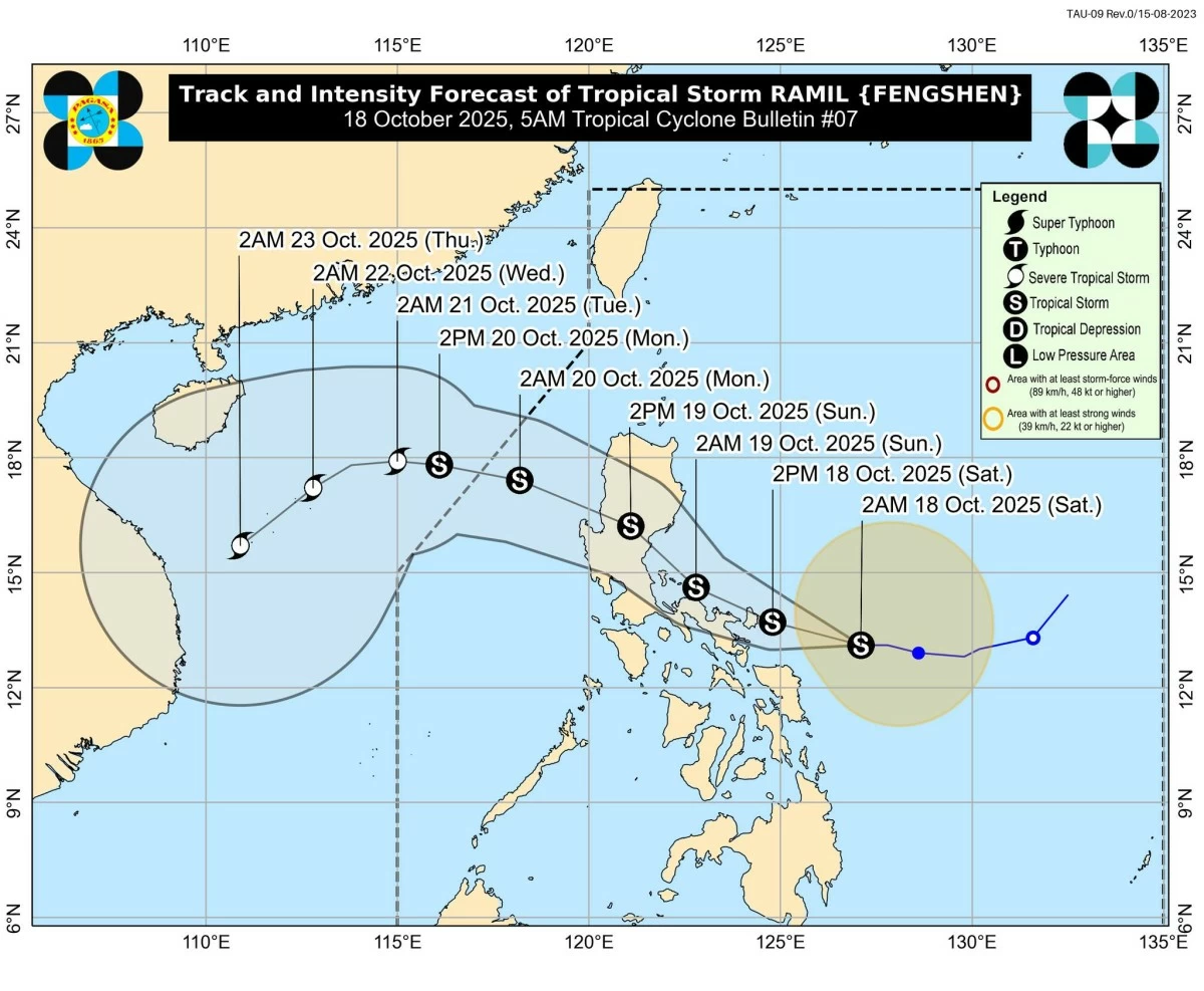
Tropical Storm Ramil (Fengshen) intensifies as it moves westward toward Luzon, prompting Signal No. 2 in parts of the Visayas. (PAGASA)
Tropical Storm Ramil (international name: Fengshen) intensified as it moved closer to Luzon, prompting the Philippine Atmospheric, Geophysical and Astronomical Services Administration (PAGASA) to raise Tropical Cyclone Wind Signal (TCWS) No. 2 in parts of the Visayas early Saturday, October 18.
In its 5 a.m. bulletin, PAGASA said the center of “Ramil” was located 305 kilometers east of Juban, Sorsogon.
“Ramil” now packs maximum sustained winds of 65 kilometers per hour (km/h) near the center, gustiness of up to 80 km/h, and a central pressure of 1000 hPa.
PAGASA said TS Ramil is moving westward at 20 km/h, with strong to gale-force winds extending up to 400 kilometers from the center.
Signal No. 2 up in Visayas areas
TCWS No. 2 is now in effect over Northern Samar, the northern portion of Eastern Samar (San Policarpo, Arteche, Oras, Dolores, Maslog, Jipapad, Taft, Can-avid), and the northern portion of Samar (Matuguinao, San Jose de Buan, Calbayog City, Gandara, Santa Margarita, Pagsanghan, and San Jorge).
Under Signal No. 2, residents can expect gale-force winds (62–88 km/h) within 24 hours, which may cause minor to moderate damage to structures and vegetation.
Meanwhile, Signal No. 1 remains hoisted over wide areas of Luzon, including Cagayan (Babuyan Islands), Isabela, Quirino, Nueva Vizcaya, Apayao, Abra, Kalinga, Mountain Province, Ifugao, Benguet, Ilocos Norte, Ilocos Sur, La Union, Pangasinan, Aurora, Nueva Ecija, the eastern portion of Bulacan (Doña Remedios Trinidad, Norzagaray, San Miguel, San Ildefonso, San Rafael, Angat), the eastern portion of Tarlac (Camiling, San Clemente, Santa Ignacia, Paniqui, Moncada, San Manuel, Anao, Ramos, Pura, Victoria, City of Tarlac, La Paz, Concepcion, and Gerona), and the eastern portion of Pampanga (Magalang, Arayat, Candaba).
Signal No. 1 is also raised over the northern and eastern portions of Quezon (Tagkawayan, Perez, Alabat, Quezon, Atimonan, Padre Burgos, Unisan, Gumaca, Plaridel, Agdangan, Pagbilao, Mauban, Calauag, Guinayangan, Lopez, Pitogo, Macalelon, General Luna, Catanauan, San Narciso, Buenavista, San Francisco, San Andres, Mulanay, General Nakar, Infanta, Real, and Sampaloc), including the Polillo Islands, Camarines Norte, the rest of Camarines Sur, Albay, Sorsogon, Burias Island, and Ticao Island.
PAGASA said strong winds and light to moderate rainfall may occur within 36 hours in these areas.
Heavy rainfall and coastal risks
PAGASA warned that “Ramil” could bring heavy rains, severe winds, and storm surges even in areas outside its projected landfall zone.
Storm surge heights could reach 1.0 to 2.0 meters in low-lying and coastal areas of Isabela, Aurora, Quezon, Marinduque, the Bicol Region, and Eastern Visayas within the next 48 hours, PAGASA added.
A Gale Warning is also in effect over the eastern seaboard of Southern Luzon, where sea conditions may become very rough, with wave heights reaching up to 4.5 meters.
PAGASA advised all vessels and small boats to remain in port until conditions improve.
Possible landfall: Bicol or Aurora-Isabela area
According to PAGASA’s forecast, “Ramil” may make landfall or pass close to Catanduanes this afternoon or evening before crossing near Camarines Norte and the Polillo Islands by early Sunday morning.
TS Ramil is then expected to move toward Aurora or Isabela for another possible landfall before exiting into the West Philippine Sea by Monday morning, October 20.
While still at tropical storm strength, PAGASA noted that Ramil could intensify into a severe tropical storm before making landfall.
The weather bureau also cautioned that shifts in the storm’s track—northward or southward—may alter the expected landfall area.
Public advised to remain vigilant
PAGASA urged residents in affected regions, especially those in flood-prone and coastal communities, to take precautionary measures and follow evacuation advisories from local authorities.
“Considering these developments, the public and disaster risk reduction and management offices concerned are advised to take all necessary measures to protect life and property,” PAGASA said.
RELATED STORY: