ADVERTISEMENT

'Ramil' makes landfall over Gubat, Sorsogon — PAGASA

Signal No. 2 up in parts of Luzon, Visayas

Published Oct 18, 2025 05:53 pm

At A Glance

  • Tropical Storm Ramil made landfall over Gubat, Sorsogon on October 18, bringing strong winds and heavy rains to parts of Luzon and Visayas.
  • PAGASA raised Signal No. 2 in several areas as Ramil may make multiple landfalls before exiting PAR on October 20.
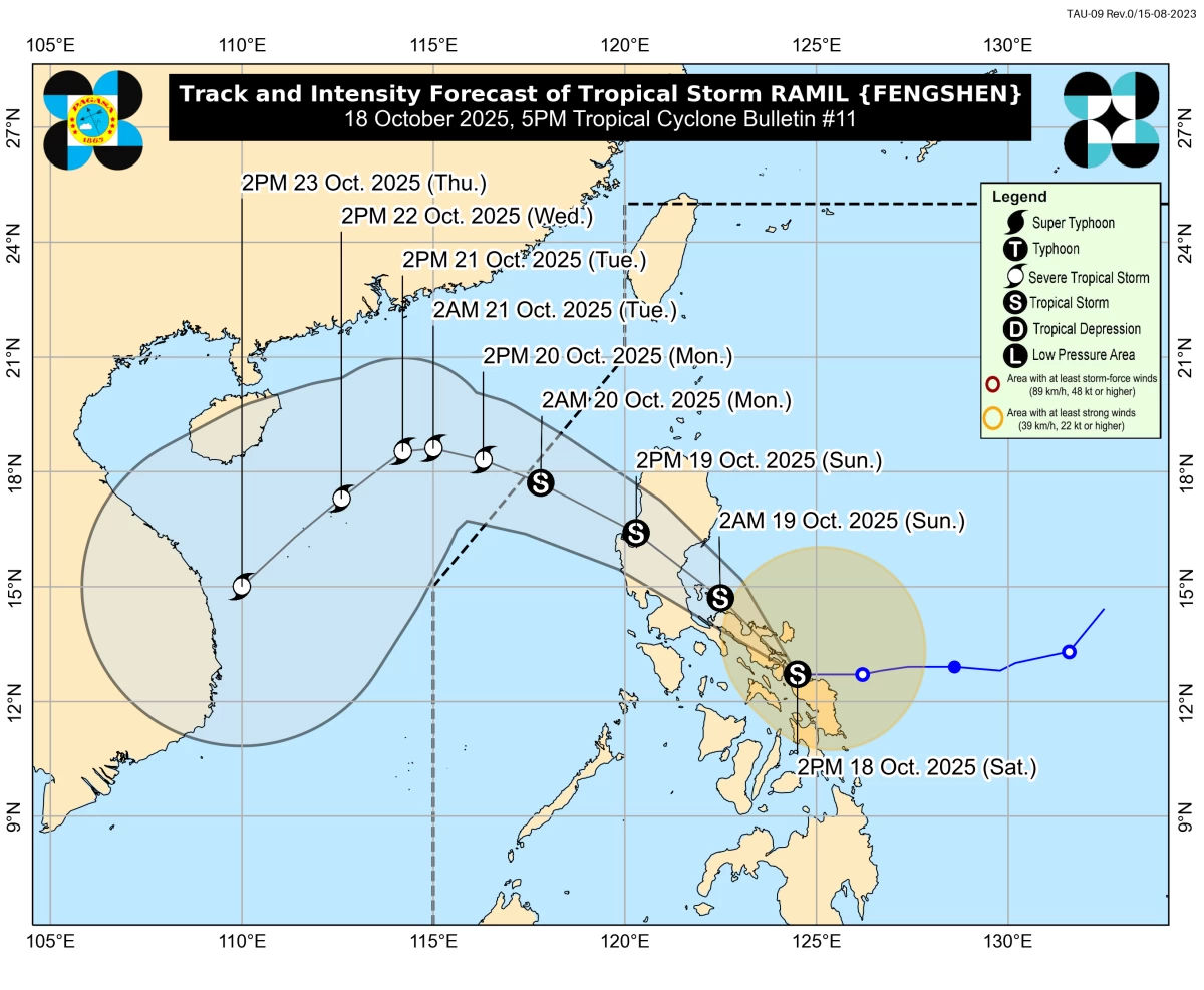
Tropical Storm Ramil made landfall over Gubat, Sorsogon, on October 18, 2025, bringing strong winds and heavy rains to parts of Luzon and Visayas, with PAGASA raising Signal No. 2 in several areas as the storm may make multiple landfalls before leaving the Philippine Area of Responsibility on October 20. (PAGASA)
Tropical Storm Ramil (international name: Fengshen) made landfall over Gubat, Sorsogon, on Saturday, October 18, according to the Philippine Atmospheric, Geophysical and Astronomical Services Administration (PAGASA).
In its 5 p.m. bulletin, PAGASA said “Ramil” made landfall at 4:10 p.m.
As of 4 p.m., the weather bureau said the center of “Ramil” was located over the coastal waters of Gubat, Sorsogon, packing maximum sustained winds of 65 kilometers per hour (km/h) near the center, gustiness of up to 90 km/h, and a central pressure of 998 hPa.
It is currently moving westward slowly, with strong to gale-force winds extending up to 400 kilometers from the storm’s center.
Signal No. 2 raised in parts of Luzon and Visayas
PAGASA hoisted Tropical Cyclone Wind Signal (TCWS) No. 2 over several areas due to the threat of gale-force winds (62 to 88 km/h), posing a minor to moderate threat to life and property:
Luzon – The southeastern portion of Isabela (Dinapigue), the southern portion of Quirino (Nagtipunan, Maddela), the southern portion of Nueva Vizcaya (Alfonso Castañeda), northern and central portions of Aurora (Casiguran, Dilasag, Dinalungan, Baler, Dipaculao, Maria Aurora, San Luis), Polillo Islands, Camarines Norte, Catanduanes, the northern and eastern portions of Camarines Sur (Tinambac, Siruma, Goa, San Jose, Lagonoy, Garchitorena, Caramoan, Presentacion, Sagñay, Tigaon), the eastern portion of Albay (Rapu-Rapu, Bacacay, City of Tabaco, Malilipot, Santo Domingo, Manito, Tiwi, Malinao), and the northeastern portion of Sorsogon (Prieto Diaz, City of Sorsogon, Gubat).
Visayas – The northern portion of Northern Samar (Laoang, Pambujan, San Roque, Mondragon, Rosario, Lavezares, San Jose, Catarman, Bobon, Palapag).
Meanwhile, Signal No. 1 remains in effect over a wider area of Luzon and the Visayas.
Luzon – Cagayan including Babuyan Islands, the rest of Isabela, the rest of Quirino, the rest of Nueva Vizcaya, Apayao, Abra, Kalinga, Mountain Province, Ifugao, Benguet, Ilocos Norte, Ilocos Sur, La Union, Pangasinan, the rest of Aurora, Nueva Ecija, the eastern portion of Bulacan (Doña Remedios Trinidad, Norzagaray, San Miguel, San Ildefonso, San Rafael, Angat), the eastern portion of Tarlac (Camiling, San Clemente, Santa Ignacia, Paniqui, Moncada, San Manuel, Anao, Ramos, Pura, Victoria, City of Tarlac, La Paz, Concepcion, Gerona), the eastern portion of Pampanga (Magalang, Arayat, Candaba), the northern and eastern portions of Quezon (Tagkawayan, Perez, Alabat, Quezon, Atimonan, Padre Burgos, Unisan, Gumaca, Plaridel, Agdangan, Pagbilao, Mauban, Calauag, Guinayangan, Lopez, Pitogo, Macalelon, General Luna, Catanauan, San Narciso, Buenavista, San Francisco, San Andres, Mulanay, General Nakar, Infanta, Real, Sampaloc), the rest of Camarines Sur, the rest of Albay, the rest of Sorsogon, Burias Island, and Ticao Island.
Visayas – The rest of Northern Samar, the northern portion of Eastern Samar (San Policarpo, Arteche, Oras, Dolores, Maslog, Jipapad, Taft, Can-avid), and the northern portion of Samar (Matuguinao, San Jose de Buan, Calbayog City, Gandara, Santa Margarita, Pagsanghan, San Jorge, Tagapul-an, Almagro, Santo Niño, Tarangnan, Paranas, City of Catbalogan, Jiabong, Motiong).
Forecast track: Multiple landfalls expected
PAGASA said Ramil will continue to move west-northwestward over the Bicol Region through tonight, October 18, until early Sunday morning, October 19.
The tropical storm is expected to pass close to or over the Polillo Islands on Sunday morning before making another landfall over Aurora Province later that morning or in the afternoon.
A possible northward shift could bring landfall over northern Quezon or southern Isabela, PAGASA added.
After crossing Northern Luzon, Ramil is forecast to emerge over the coastal waters of Pangasinan or La Union by Sunday evening and exit the Philippine Area of Responsibility (PAR) on Monday, October 20.
Once over the West Philippine Sea, the system may re-intensify into a severe tropical storm.
Rainfall, winds, and coastal hazards
PAGASA said heavy rainfall is expected across the Bicol Region, Quezon, Aurora, and parts of Northern Samar, with possible flooding and landslides, especially in mountainous areas.
Storm surges of up to 2.0 meters are possible in low-lying and coastal areas of Isabela, Aurora, Quezon, Marinduque, the Bicol Region, Northern Samar, Eastern Samar, and Samar within 36 hours, PAGASA warned.
A Gale Warning is in effect over the eastern seaboards of Southern Luzon, where sea conditions may reach up to 5 meters. Sea travel remains risky for all types of vessels, especially small boats and motorbancas.
PAGASA advised residents and local disaster officials to take precautionary measures against strong winds, heavy rainfall, and possible flooding or storm surges.
Communities in high-risk areas are urged to follow evacuation advisories and stay tuned for local rainfall and thunderstorm warnings issued by PAGASA’s Regional Services Divisions. 
RELATED STORY: 
https://mb.com.ph/2025/10/17/tropical-cyclone-ramil-tracker

Related Tags

Ramil PH Tropical Storm Ramil Fengshen PAGASA weather update Signal No. 2 October 2025 typhoon PAGASA weather bulletin
ADVERTISEMENT
.most-popular .layout-ratio{ padding-bottom: 79.13%; } @media (min-width: 768px) and (max-width: 1024px) { .widget-title { font-size: 15px !important; } }

{{ articles_filter_1561_widget.title }}

.most-popular .layout-ratio{ padding-bottom: 79.13%; } @media (min-width: 768px) and (max-width: 1024px) { .widget-title { font-size: 15px !important; } }

{{ articles_filter_1562_widget.title }}

.most-popular .layout-ratio{ padding-bottom: 79.13%; } @media (min-width: 768px) and (max-width: 1024px) { .widget-title { font-size: 15px !important; } }

{{ articles_filter_1563_widget.title }}

{{ articles_filter_1564_widget.title }}

.mb-article-details { position: relative; } .mb-article-details .article-body-preview, .mb-article-details .article-body-summary{ font-size: 17px; line-height: 30px; font-family: "Libre Caslon Text", serif; color: #000; } .mb-article-details .article-body-preview iframe , .mb-article-details .article-body-summary iframe{ width: 100%; margin: auto; } .read-more-background { background: linear-gradient(180deg, color(display-p3 1.000 1.000 1.000 / 0) 13.75%, color(display-p3 1.000 1.000 1.000 / 0.8) 30.79%, color(display-p3 1.000 1.000 1.000) 72.5%); position: absolute; height: 200px; width: 100%; bottom: 0; display: flex; justify-content: center; align-items: center; padding: 0; } .read-more-background a{ color: #000; } .read-more-btn { padding: 17px 45px; font-family: Inter; font-weight: 700; font-size: 18px; line-height: 16px; text-align: center; vertical-align: middle; border: 1px solid black; background-color: white; } .hidden { display: none; }
function initializeAllSwipers() { // Get all hidden inputs with cms_article_id document.querySelectorAll('[id^="cms_article_id_"]').forEach(function (input) { const cmsArticleId = input.value; const articleSelector = '#article-' + cmsArticleId + ' .body_images'; const swiperElement = document.querySelector(articleSelector); if (swiperElement && !swiperElement.classList.contains('swiper-initialized')) { new Swiper(articleSelector, { loop: true, pagination: false, navigation: { nextEl: '#article-' + cmsArticleId + ' .swiper-button-next', prevEl: '#article-' + cmsArticleId + ' .swiper-button-prev', }, }); } }); } setTimeout(initializeAllSwipers, 3000); const intersectionObserver = new IntersectionObserver( (entries) => { entries.forEach((entry) => { if (entry.isIntersecting) { const newUrl = entry.target.getAttribute("data-url"); if (newUrl) { history.pushState(null, null, newUrl); let article = entry.target; // Extract metadata const author = article.querySelector('.author-section').textContent.replace('By', '').trim(); const section = article.querySelector('.section-info ').textContent.replace(' ', ' '); const title = article.querySelector('.article-title h1').textContent; // Parse URL for Chartbeat path format const parsedUrl = new URL(newUrl, window.location.origin); const cleanUrl = parsedUrl.host + parsedUrl.pathname; // Update Chartbeat configuration if (typeof window._sf_async_config !== 'undefined') { window._sf_async_config.path = cleanUrl; window._sf_async_config.sections = section; window._sf_async_config.authors = author; } // Track virtual page view with Chartbeat if (typeof pSUPERFLY !== 'undefined' && typeof pSUPERFLY.virtualPage === 'function') { try { pSUPERFLY.virtualPage({ path: cleanUrl, title: title, sections: section, authors: author }); } catch (error) { console.error('ping error', error); } } // Optional: Update document title if (title && title !== document.title) { document.title = title; } } } }); }, { threshold: 0.1 } ); function showArticleBody(button) { const article = button.closest("article"); const summary = article.querySelector(".article-body-summary"); const body = article.querySelector(".article-body-preview"); const readMoreSection = article.querySelector(".read-more-background"); // Hide summary and read-more section summary.style.display = "none"; readMoreSection.style.display = "none"; // Show the full article body body.classList.remove("hidden"); } document.addEventListener("DOMContentLoaded", () => { let loadCount = 0; // Track how many times articles are loaded const offset = [1, 2, 3, 4, 5, 6, 7, 8, 9, 10]; // Offset values const currentUrl = window.location.pathname.substring(1); let isLoading = false; // Prevent multiple calls if (!currentUrl) { console.log("Current URL is invalid."); return; } const sentinel = document.getElementById("load-more-sentinel"); if (!sentinel) { console.log("Sentinel element not found."); return; } function isSentinelVisible() { const rect = sentinel.getBoundingClientRect(); return ( rect.top < window.innerHeight && rect.bottom >= 0 ); } function onScroll() { if (isLoading) return; if (isSentinelVisible()) { if (loadCount >= offset.length) { console.log("Maximum load attempts reached."); window.removeEventListener("scroll", onScroll); return; } isLoading = true; const currentOffset = offset[loadCount]; window.loadMoreItems().then(() => { let article = document.querySelector('#widget_1690 > div:nth-last-of-type(2) article'); intersectionObserver.observe(article) loadCount++; }).catch(error => { console.error("Error loading more items:", error); }).finally(() => { isLoading = false; }); } } window.addEventListener("scroll", onScroll); });

Sign up by email to receive news.