


Manila Bulletin
 Philippines
National
PAGASA: 'Ramil' slows down east of Sorsogon; landfall possible in Catanduanes
Philippines
National
PAGASA: 'Ramil' slows down east of Sorsogon; landfall possible in Catanduanes
Philippines
National
PAGASA: 'Ramil' slows down east of Sorsogon; landfall possible in Catanduanes
PAGASA: 'Ramil' slows down east of Sorsogon; landfall possible in Catanduanes
Published Oct 18, 2025 08:58 am


Tropical Storm Ramil slows down east of Sorsogon; PAGASA warns of possible Catanduanes landfall and heavy rains over Luzon and Visayas on October 18, 2025. (PAGASA)
Tropical Storm Ramil (international name: Fengshen) has slightly slowed down while moving west-northwestward over the sea east of Sorsogon early Saturday, October 18, the Philippine Atmospheric, Geophysical and Astronomical Services Administration (PAGASA) said.
In its 8 a.m. bulletin, PAGASA said the center of Ramil was located 260 kilometers east of Juban, Sorsogon, packing maximum sustained winds of 65 kilometers per hour (km/h) near the center and gustiness of up to 80 km/h.
It is moving west-northwestward at 15 km/h, with strong to gale-force winds extending outward up to 400 kilometers from the center.
PAGASA said “Ramil” is expected to move toward Central to Southern Luzon, possibly making landfall or passing close to Catanduanes this afternoon or evening.
It will then track west-northwestward toward Camarines Norte and the Polillo Islands by Sunday morning (October 19), before turning northwestward toward Aurora or Isabela for another potential landfall, PAGASA added.
“Ramil” is forecast to exit the Philippine Area of Responsibility (PAR) by Monday morning (October 20), according to PAGASA.
The weather bureau also warned that “Ramil” may still intensify into a severe tropical storm before landfall.
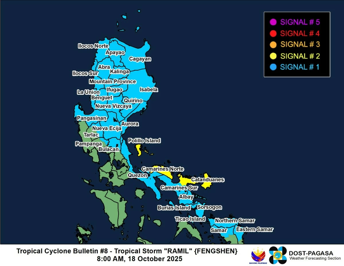
Areas under Tropical Cyclone Wind Signals
PAGASA said Tropical Cyclone Wind Signal (TCWS) No. 2 is raised over several Luzon areas that may experience winds of more than 62 km/h and up to 88 km/h within 24 hours, including:
- Camarines Norte
- Catanduanes
- the northern portion of Camarines Sur (Tinambac, Siruma, Goa, San Jose, Lagonoy, Garchitorena, Caramoan, Presentacion)
- Polillo Islands
Meanwhile, Signal No. 1 is raised in various Luzon areas such as Cagayan (including Babuyan Islands), Isabela, Quirino, Nueva Vizcaya, Apayao, Abra, Kalinga, Mountain Province, Ifugao, Benguet, Ilocos Norte, Ilocos Sur, La Union, Pangasinan, Aurora, Nueva Ecija, the eastern portion of Bulacan (Doña Remedios Trinidad, Norzagaray, San Miguel, San Ildefonso, San Rafael, Angat), the eastern portion of Tarlac (Camiling, San Clemente, Santa Ignacia, Paniqui, Moncada, San Manuel, Anao, Ramos, Pura, Victoria, City of Tarlac, La Paz, Concepcion, Gerona), the eastern portion of Pampanga (Magalang, Arayat, Candaba), the northern and eastern portions of Quezon (Tagkawayan, Perez, Alabat, Quezon, Atimonan, Padre Burgos, Unisan, Gumaca, Plaridel, Agdangan, Pagbilao, Mauban, Calauag, Guinayangan, Lopez, Pitogo, Macalelon, General Luna, Catanauan, San Narciso, Buenavista, San Francisco, San Andres, Mulanay, General Nakar, Infanta, Real, Sampaloc), including Polillo Islands, the rest of Camarines Sur, Albay, Sorsogon, Burias Island, and Ticao Island.
Signal No. 1 is also hoisted over Visayas areas, including Northern Samar, the northern portion of Eastern Samar (San Policarpo, Arteche, Oras, Dolores, Maslog, Jipapad, Taft, Can-Avid), and the northern portion of Samar (Matuguinao, San Jose de Buan, Calbayog City, Gandara, Santa Margarita, Pagsanghan, San Jorge).
Rainfall and flooding threats
PAGASA said Tropical Storm Ramil’s outer rainbands and the enhanced easterlies are expected to bring heavy rain and strong winds across Cagayan Valley, Calabarzon, Metro Manila, Ilocos Region, Marinduque, Mindoro provinces, and Masbate on October 18, and over Calabarzon, Central Luzon, Metro Manila, and Eastern Samar on October 19.
Residents in flood-prone and mountainous areas are advised to remain alert for possible flash floods and landslides, PAGASA said.
Coastal and sea conditions
PAGASA warned that a storm surge of 1.0 to 2.0 meters is possible within the next 48 hours over low-lying or exposed coastal areas in Isabela, Aurora, Quezon, Marinduque, Camarines Norte, Camarines Sur, Catanduanes, Albay, Sorsogon, Masbate, Romblon, Northern Samar, Eastern Samar, Western Samar, Ilocos Norte, Ilocos Sur, La Union, Pangasinan, and Zambales.
A Gale Warning is also in effect over the eastern seaboard of Southern Luzon, with very rough seas up to 4.5 meters expected over the coastal waters of Catanduanes, Camarines Sur, Camarines Norte, Cagayan, and Isabela.
PAGASA said sea travel is risky for all types of vessels, and mariners are advised to remain in port or seek shelter until conditions improve.
'Ramil': Forecast track
By 5 p.m. on October 18, PAGASA said Tropical Storm Ramil was located over the coastal waters of Viga, Catanduanes.
By 5 a.m. on October 19, it is forecast to be 110 kilometers east-northeast of Infanta, Quezon, before moving inland and reaching the vicinity of Bakun, Benguet, by 5 p.m. the same day.
By 5 a.m. on October 20, PAGASA said “Ramil” is expected to be 285 kilometers west of Sinait, Ilocos Sur, and likely to exit the Philippine Area of Responsibility.
PAGASA added that “Ramil” may slightly weaken while crossing Luzon’s rugged terrain but could reintensify once it reaches the West Philippine Sea.
Residents are urged to secure their properties, avoid unnecessary travel, and continue monitoring official updates.
RELATED STORY: