ADVERTISEMENT

'Paolo' exits PAR; Signal No. 1 still up in several Luzon areas — PAGASA

Published Oct 4, 2025 07:16 am
Severe Tropical Storm Paolo exits PAR but Signal No. 1 remains in parts of Luzon, bringing strong winds, rough seas, and coastal flooding. (PAGASA)
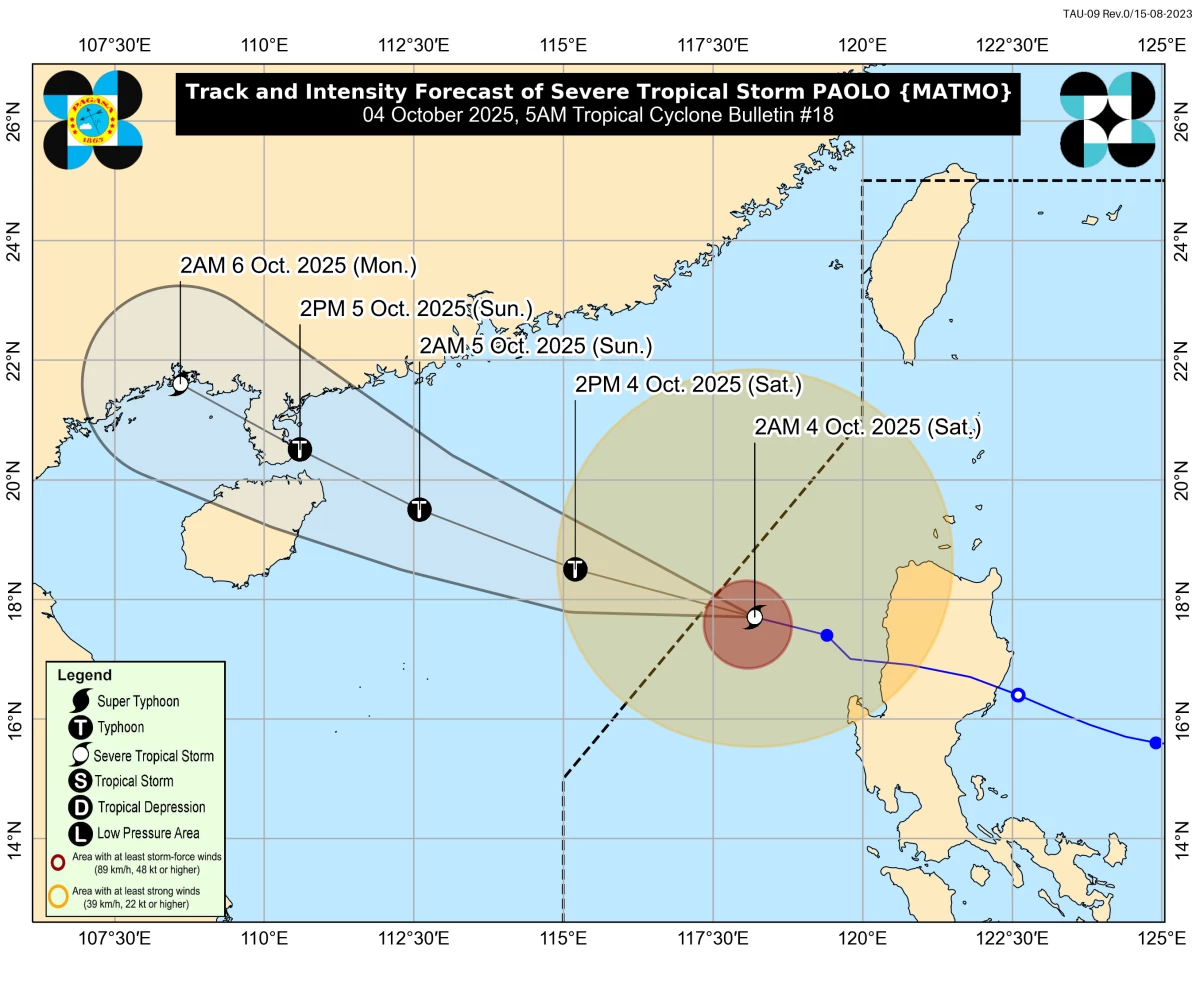
Severe Tropical Storm Paolo exited the Philippine Area of Responsibility (PAR) early Saturday morning, October 4, but the Philippine Atmospheric, Geophysical and Astronomical Services Administration (PAGASA) warned that it will continue to bring strong winds, rough seas, and possible coastal flooding in several parts of Luzon.
As of 5 a.m., the state weather bureau located the center of “Paolo” 295 kilometers west of Sinait, Ilocos Sur. It was packing maximum sustained winds of 110 km/h near the center and gusts of up to 135 km/h.
The storm is moving west-northwestward at 20 km/h toward southern China and is forecast to re-intensify into a typhoon later today over the West Philippine Sea, PAGASA said.
Areas under Wind Signal No. 1
Despite exiting PAR, PAGASA said Tropical Cyclone Wind Signal (TCWS) No. 1 remains in effect over several areas in Luzon, where minimal to minor impacts from strong winds are expected. These include:
- The western portion of Abra (Danglas, Bangued, Langiden, San Quintin, Pidigan, San Isidro, Pilar, Villaviciosa, Peñarrubia, Manabo, Luba, Tayum, La Paz, Lagayan, Tubo, Bucay, Dolores, San Juan, Lagangilang)
- The western portion of Benguet (Bakun, Kibungan, Kapangan, Sablan, Tuba, Mankayan, Tublay, La Trinidad, Baguio City)
- The southern portion of Ilocos Norte (Nueva Era, Banna, Badoc, Pinili, City of Batac, Paoay, Marcos, Currimao)
- Ilocos Sur
- La Union
- The western and central portions of Pangasinan (Bolinao, Bani, Agno, Burgos, Dasol, Mabini, Infanta, Bugallon, Labrador, Sual, City of Alaminos, Lingayen, Aguilar, Mangatarem, Urbiztondo, San Carlos City, Binmaley, Dagupan City, Calasiao, Basista, Bayambang, San Fabian, San Jacinto, Mangaldan, Mapandan, Santa Barbara, Malasiqui, Alcala, Bautista, Santo Tomas, Villasis, City of Urdaneta, Manaoag, Laoac, Pozorrubio, Sison)
- The northern portion of Zambales (Iba, Candelaria, Palauig, Santa Cruz, Masinloc)
PAGASA added that winds may be stronger in coastal and upland areas, while communities shielded from the prevailing wind direction may experience less impact.
Storm surge and coastal hazards
The weather bureau also warned of possible storm surges up to 2.0 meters in low-lying and exposed coastal areas of Ilocos Norte, Ilocos Sur, La Union, Pangasinan, and Zambales.
Residents in these areas were advised to remain alert and heed local government advisories.
Meanwhile, moderate to rough seas will prevail over the seaboards of Northern and Central Luzon. PAGASA said waves may reach up to 4.0 meters in Mainland Cagayan, Babuyan Islands, Ilocos Norte, Ilocos Sur, and La Union; up to 3.5 meters in Batanes and Pangasinan; up to 2.5 meters in Isabela, northern Aurora, and Zambales; and up to 2.0 meters in Aurora, western Bataan, and Lubang Island.
Small fishing boats and motorbancas are strongly advised not to venture out to sea.
Rainfall and winds beyond wind signal areas
PAGASA said the outer rainbands of “Paolo” will continue to bring strong to gale-force gusts over Batanes, Babuyan Islands, northern Cagayan, Apayao, Zambales, and Bataan throughout the day.
Even areas not under a wind signal may still experience heavy rainfall, flooding, and landslides, the bureau warned.
Forecast track
According to PAGASA, “Paolo” is expected to move further away from the Philippines with the following forecast positions:
October 4, 2 p.m.: 565 km west of Laoag City, Ilocos Norte (outside PAR)
October 5, 2 a.m.: 930 km west of Extreme Northern Luzon (outside PAR)
October 5, 2 p.m.: 1,185 km west of Extreme Northern Luzon or near Guangdong Province, China
October 6, 2 a.m.: vicinity of Guangxi, China
While the storm is no longer expected to make landfall in the Philippines, PAGASA emphasized that Northern and Central Luzon may still experience dangerous weather conditions within the next 24 hours.
The bureau urged residents in affected areas to stay vigilant against possible flash floods, landslides, and coastal inundation. Local governments are advised to implement precautionary measures, while fisherfolk and sea travelers should avoid risky maritime activities. 
RELATED STORY: 
https://mb.com.ph/2025/10/01/tropical-cyclone-paolo-tracker

Related Tags

PaoloPH Severe Tropical Storm Paolo Paolo exits PAR PAGASA weather update storm surge warning Luzon PAGASA typhoon update October 2025
ADVERTISEMENT
.most-popular .layout-ratio{ padding-bottom: 79.13%; } @media (min-width: 768px) and (max-width: 1024px) { .widget-title { font-size: 15px !important; } }

{{ articles_filter_1561_widget.title }}

.most-popular .layout-ratio{ padding-bottom: 79.13%; } @media (min-width: 768px) and (max-width: 1024px) { .widget-title { font-size: 15px !important; } }

{{ articles_filter_1562_widget.title }}

.most-popular .layout-ratio{ padding-bottom: 79.13%; } @media (min-width: 768px) and (max-width: 1024px) { .widget-title { font-size: 15px !important; } }

{{ articles_filter_1563_widget.title }}

{{ articles_filter_1564_widget.title }}

.mb-article-details { position: relative; } .mb-article-details .article-body-preview, .mb-article-details .article-body-summary{ font-size: 17px; line-height: 30px; font-family: "Libre Caslon Text", serif; color: #000; } .mb-article-details .article-body-preview iframe , .mb-article-details .article-body-summary iframe{ width: 100%; margin: auto; } .read-more-background { background: linear-gradient(180deg, color(display-p3 1.000 1.000 1.000 / 0) 13.75%, color(display-p3 1.000 1.000 1.000 / 0.8) 30.79%, color(display-p3 1.000 1.000 1.000) 72.5%); position: absolute; height: 200px; width: 100%; bottom: 0; display: flex; justify-content: center; align-items: center; padding: 0; } .read-more-background a{ color: #000; } .read-more-btn { padding: 17px 45px; font-family: Inter; font-weight: 700; font-size: 18px; line-height: 16px; text-align: center; vertical-align: middle; border: 1px solid black; background-color: white; } .hidden { display: none; }
function initializeAllSwipers() { // Get all hidden inputs with cms_article_id document.querySelectorAll('[id^="cms_article_id_"]').forEach(function (input) { const cmsArticleId = input.value; const articleSelector = '#article-' + cmsArticleId + ' .body_images'; const swiperElement = document.querySelector(articleSelector); if (swiperElement && !swiperElement.classList.contains('swiper-initialized')) { new Swiper(articleSelector, { loop: true, pagination: false, navigation: { nextEl: '#article-' + cmsArticleId + ' .swiper-button-next', prevEl: '#article-' + cmsArticleId + ' .swiper-button-prev', }, }); } }); } setTimeout(initializeAllSwipers, 3000); const intersectionObserver = new IntersectionObserver( (entries) => { entries.forEach((entry) => { if (entry.isIntersecting) { const newUrl = entry.target.getAttribute("data-url"); if (newUrl) { history.pushState(null, null, newUrl); let article = entry.target; // Extract metadata const author = article.querySelector('.author-section').textContent.replace('By', '').trim(); const section = article.querySelector('.section-info ').textContent.replace(' ', ' '); const title = article.querySelector('.article-title h1').textContent; // Parse URL for Chartbeat path format const parsedUrl = new URL(newUrl, window.location.origin); const cleanUrl = parsedUrl.host + parsedUrl.pathname; // Update Chartbeat configuration if (typeof window._sf_async_config !== 'undefined') { window._sf_async_config.path = cleanUrl; window._sf_async_config.sections = section; window._sf_async_config.authors = author; } // Track virtual page view with Chartbeat if (typeof pSUPERFLY !== 'undefined' && typeof pSUPERFLY.virtualPage === 'function') { try { pSUPERFLY.virtualPage({ path: cleanUrl, title: title, sections: section, authors: author }); } catch (error) { console.error('ping error', error); } } // Optional: Update document title if (title && title !== document.title) { document.title = title; } } } }); }, { threshold: 0.1 } ); function showArticleBody(button) { const article = button.closest("article"); const summary = article.querySelector(".article-body-summary"); const body = article.querySelector(".article-body-preview"); const readMoreSection = article.querySelector(".read-more-background"); // Hide summary and read-more section summary.style.display = "none"; readMoreSection.style.display = "none"; // Show the full article body body.classList.remove("hidden"); } document.addEventListener("DOMContentLoaded", () => { let loadCount = 0; // Track how many times articles are loaded const offset = [1, 2, 3, 4, 5, 6, 7, 8, 9, 10]; // Offset values const currentUrl = window.location.pathname.substring(1); let isLoading = false; // Prevent multiple calls if (!currentUrl) { console.log("Current URL is invalid."); return; } const sentinel = document.getElementById("load-more-sentinel"); if (!sentinel) { console.log("Sentinel element not found."); return; } function isSentinelVisible() { const rect = sentinel.getBoundingClientRect(); return ( rect.top < window.innerHeight && rect.bottom >= 0 ); } function onScroll() { if (isLoading) return; if (isSentinelVisible()) { if (loadCount >= offset.length) { console.log("Maximum load attempts reached."); window.removeEventListener("scroll", onScroll); return; } isLoading = true; const currentOffset = offset[loadCount]; window.loadMoreItems().then(() => { let article = document.querySelector('#widget_1690 > div:nth-last-of-type(2) article'); intersectionObserver.observe(article) loadCount++; }).catch(error => { console.error("Error loading more items:", error); }).finally(() => { isLoading = false; }); } } window.addEventListener("scroll", onScroll); });

Sign up by email to receive news.