ADVERTISEMENT

'Opong' intensifies into severe tropical storm; Signal No. 2 raised over parts of E. Visayas

Cyclone may reach typhoon category before Bicol landfall

Published Sep 24, 2025 06:03 pm
PAGASA
PAGASA
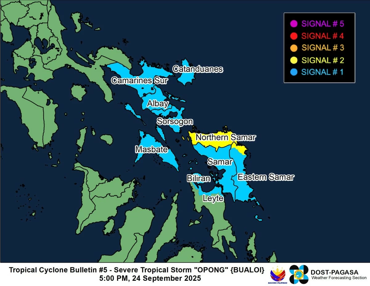
Severe Tropical Storm Opong (international name: Bualoi) intensified further over the Philippine Sea on Wednesday afternoon, Sept. 24, prompting the Philippine Atmospheric, Geophysical and Astronomical Services Administration (PAGASA) to raise Tropical Cyclone Wind Signal No. 2 over parts of Eastern Visayas.
In its 5 p.m. bulletin, PAGASA said Opong was last located 670 kilometers east of Surigao City, Surigao del Norte, with maximum sustained winds of 95 kilometers per hour (kph) near the center and gustiness of up to 115 kph.
It was moving west-northwestward at 20 kph.
Signal No. 2 raised
As the system strengthened, PAGASA hoisted Signal No. 2 over Northern Samar and northern portion of Eastern Samar (San Policarpo, Oras, Jipapad, and Arteche).
Meanwhile, Signal No. 1 was raised over Catanduanes, Camarines Sur, Albay, Sorsogon, Masbate, Samar, the rest of Eastern Samar, Biliran, and northern portion of Leyte (Barugo, San Miguel, Babatngon, Tacloban City, Calubian, Leyte, Capoocan, Carigara, and Palo).
PAGASA said areas under Signal No. 2 may experience minor to moderate impacts from gale-force winds, while those under Signal No. 1 may see minimal to minor impacts from strong winds.
PAGASA also noted that the highest possible wind signal during Opong’s passage is Signal No. 4.
Landfall outlook
On its current track, Opong is forecast to continue moving west-northwestward and may make landfall over Bicol region by Friday, Sept. 26, either in the morning or afternoon, before crossing Southern Luzon, including Metro Manila.
It was earlier projected to make landfall over Bicol and traverse the landmass of Southern Luzon and Metro Manila as a severe tropical storm, but with its intensification, PAGASA now sees the possibility of Opong reaching typhoon category before landfall.
It added that as the center of the storm may pass close to Metro Manila, Signal No. 3 or 4 may be raised in the region.
READ MORE:
https://mb.com.ph/2025/09/24/signal-no-1-up-in-3-eastern-visayas-areas-as-opong-intensifies
The storm may weaken slightly while crossing Luzon but could reintensify once it reaches the West Philippine Sea, before exiting the Philippine Area of Responsibility (PAR) by Saturday, Sept. 27.
Heavy rainfall forecast
PAGASA warned that Opong will bring widespread heavy rains in the coming days.
From Wednesday until Thursday afternoon, Sept. 25, moderate to heavy rains (50 to 100 millimeters) are expected in Northern Samar and Eastern Samar.
By Thursday afternoon until Friday afternoon, rains will be intense to torrential (more than 200 mm) in Sorsogon, Masbate, Northern Samar, and Eastern Samar.
Heavy to intense rainfall (100 to 200 mm) may also affect Quezon, Marinduque, Camarines Norte, Camarines Sur, Catanduanes, Albay, Samar, and Biliran.
Meanwhile, moderate to heavy rains are possible in Isabela, Cavite, Occidental and Oriental Mindoro, Batangas, Laguna, Aurora, Romblon, Aklan, Capiz, Cebu, Southern Leyte, and Leyte.
From Friday afternoon to Saturday afternoon, heavy to intense rainfall is forecast over Metro Manila, Aurora, Bulacan, Pampanga, Zambales, Bataan, Quezon, Cavite, Batangas, Laguna, Rizal, Marinduque, Occidental and Oriental Mindoro, Romblon, Camarines Norte, and Camarines Sur.
Moderate to heavy rainfall may also affect Albay, Sorsogon, Catanduanes, Masbate, Pangasinan, Quirino, Tarlac, Nueva Vizcaya, Nueva Ecija, Cagayan, Isabela, and Northern Samar.
‘Habagat’ rains
The southwest monsoon (habagat), enhanced by both Super Typhoon Ragasa (formerly “Nando”) and Severe Tropical Storm Opong, will also bring rains in some areas.
From Thursday afternoon until Friday afternoon, 50 to 100 mm of rain is likely in Palawan, Antique, Iloilo, Guimaras, Negros Occidental, and Negros Oriental.
By Friday afternoon to Saturday afternoon, similar amounts may be experienced in Palawan, Antique, Aklan, and Negros Occidental.
Storm surge, rough seas
PAGASA also warned that storm surge and rough seas are expected in areas along Opong’s path.
A storm surge of one to three meters is possible within the next 24 hours in low-lying or exposed coastal areas of Camarines Sur, Catanduanes, Albay, Sorsogon, Masbate, Northern Samar, Eastern Samar, Samar, and Biliran.
Seas off the eastern seaboards of Northern Samar, Eastern Samar, Catanduanes, Dinagat Islands, and Davao Oriental may become moderate to rough, with waves reaching up to three meters.
PAGASA advised operators of small vessels to avoid sea travel under these conditions.

Related Tags

SEVERE TROPICAL STORM OPONG BUALOI PAGASA LANDFALL SIGNAL NO. 2
ADVERTISEMENT
.most-popular .layout-ratio{ padding-bottom: 79.13%; } @media (min-width: 768px) and (max-width: 1024px) { .widget-title { font-size: 15px !important; } }

{{ articles_filter_1561_widget.title }}

.most-popular .layout-ratio{ padding-bottom: 79.13%; } @media (min-width: 768px) and (max-width: 1024px) { .widget-title { font-size: 15px !important; } }

{{ articles_filter_1562_widget.title }}

.most-popular .layout-ratio{ padding-bottom: 79.13%; } @media (min-width: 768px) and (max-width: 1024px) { .widget-title { font-size: 15px !important; } }

{{ articles_filter_1563_widget.title }}

{{ articles_filter_1564_widget.title }}

.mb-article-details { position: relative; } .mb-article-details .article-body-preview, .mb-article-details .article-body-summary{ font-size: 17px; line-height: 30px; font-family: "Libre Caslon Text", serif; color: #000; } .mb-article-details .article-body-preview iframe , .mb-article-details .article-body-summary iframe{ width: 100%; margin: auto; } .read-more-background { background: linear-gradient(180deg, color(display-p3 1.000 1.000 1.000 / 0) 13.75%, color(display-p3 1.000 1.000 1.000 / 0.8) 30.79%, color(display-p3 1.000 1.000 1.000) 72.5%); position: absolute; height: 200px; width: 100%; bottom: 0; display: flex; justify-content: center; align-items: center; padding: 0; } .read-more-background a{ color: #000; } .read-more-btn { padding: 17px 45px; font-family: Inter; font-weight: 700; font-size: 18px; line-height: 16px; text-align: center; vertical-align: middle; border: 1px solid black; background-color: white; } .hidden { display: none; }
function initializeAllSwipers() { // Get all hidden inputs with cms_article_id document.querySelectorAll('[id^="cms_article_id_"]').forEach(function (input) { const cmsArticleId = input.value; const articleSelector = '#article-' + cmsArticleId + ' .body_images'; const swiperElement = document.querySelector(articleSelector); if (swiperElement && !swiperElement.classList.contains('swiper-initialized')) { new Swiper(articleSelector, { loop: true, pagination: false, navigation: { nextEl: '#article-' + cmsArticleId + ' .swiper-button-next', prevEl: '#article-' + cmsArticleId + ' .swiper-button-prev', }, }); } }); } setTimeout(initializeAllSwipers, 3000); const intersectionObserver = new IntersectionObserver( (entries) => { entries.forEach((entry) => { if (entry.isIntersecting) { const newUrl = entry.target.getAttribute("data-url"); if (newUrl) { history.pushState(null, null, newUrl); let article = entry.target; // Extract metadata const author = article.querySelector('.author-section').textContent.replace('By', '').trim(); const section = article.querySelector('.section-info ').textContent.replace(' ', ' '); const title = article.querySelector('.article-title h1').textContent; // Parse URL for Chartbeat path format const parsedUrl = new URL(newUrl, window.location.origin); const cleanUrl = parsedUrl.host + parsedUrl.pathname; // Update Chartbeat configuration if (typeof window._sf_async_config !== 'undefined') { window._sf_async_config.path = cleanUrl; window._sf_async_config.sections = section; window._sf_async_config.authors = author; } // Track virtual page view with Chartbeat if (typeof pSUPERFLY !== 'undefined' && typeof pSUPERFLY.virtualPage === 'function') { try { pSUPERFLY.virtualPage({ path: cleanUrl, title: title, sections: section, authors: author }); } catch (error) { console.error('ping error', error); } } // Optional: Update document title if (title && title !== document.title) { document.title = title; } } } }); }, { threshold: 0.1 } ); function showArticleBody(button) { const article = button.closest("article"); const summary = article.querySelector(".article-body-summary"); const body = article.querySelector(".article-body-preview"); const readMoreSection = article.querySelector(".read-more-background"); // Hide summary and read-more section summary.style.display = "none"; readMoreSection.style.display = "none"; // Show the full article body body.classList.remove("hidden"); } document.addEventListener("DOMContentLoaded", () => { let loadCount = 0; // Track how many times articles are loaded const offset = [1, 2, 3, 4, 5, 6, 7, 8, 9, 10]; // Offset values const currentUrl = window.location.pathname.substring(1); let isLoading = false; // Prevent multiple calls if (!currentUrl) { console.log("Current URL is invalid."); return; } const sentinel = document.getElementById("load-more-sentinel"); if (!sentinel) { console.log("Sentinel element not found."); return; } function isSentinelVisible() { const rect = sentinel.getBoundingClientRect(); return ( rect.top < window.innerHeight && rect.bottom >= 0 ); } function onScroll() { if (isLoading) return; if (isSentinelVisible()) { if (loadCount >= offset.length) { console.log("Maximum load attempts reached."); window.removeEventListener("scroll", onScroll); return; } isLoading = true; const currentOffset = offset[loadCount]; window.loadMoreItems().then(() => { let article = document.querySelector('#widget_1690 > div:nth-last-of-type(2) article'); intersectionObserver.observe(article) loadCount++; }).catch(error => { console.error("Error loading more items:", error); }).finally(() => { isLoading = false; }); } } window.addEventListener("scroll", onScroll); });

Sign up by email to receive news.