


Manila Bulletin
 Philippines
National
PAGASA: Signal No. 5 possible as 'Nando' may intensify into a super typhoon
Philippines
National
PAGASA: Signal No. 5 possible as 'Nando' may intensify into a super typhoon
Philippines
National
PAGASA: Signal No. 5 possible as 'Nando' may intensify into a super typhoon
PAGASA: Signal No. 5 possible as 'Nando' may intensify into a super typhoon
'Mirasol' exits PAR, 'Nando' accelerates over the Philippine Sea with Babuyan landfall possible
Published Sep 18, 2025 06:47 pm


Tropical Depression Nando has accelerated northwestward over the Philippine Sea. (PAGASA)
The Philippine Atmospheric, Geophysical and Astronomical Services Administration (PAGASA) warned on Thursday, September 18, that Tropical Depression Nando may intensify into a super typhoon during its passage over the Philippine Sea — raising the possibility of the highest storm alert: Tropical Cyclone Wind Signal (TCWS) No. 5.
In its 5 p.m. bulletin, PAGASA said “Nando” accelerated northwestward over the Philippine Sea and was spotted 1,260 km east of Central Luzon, carrying maximum sustained winds of 55 km/h and gusts of up to 70 km/h. It is moving northwestward at 15 km/h.
PAGASA said “Nando” may also enhance the southwest monsoon (habagat) as it approaches land.
“Wind Signal No. 1 will be hoisted over Northern Luzon as early as Saturday, September 20, and the highest wind signal that may be raised throughout its passage is Signal No. 5, considering that this tropical cyclone has the potential to reach super typhoon category,” PAGASA said.
Possible landfall in the Babuyan Islands
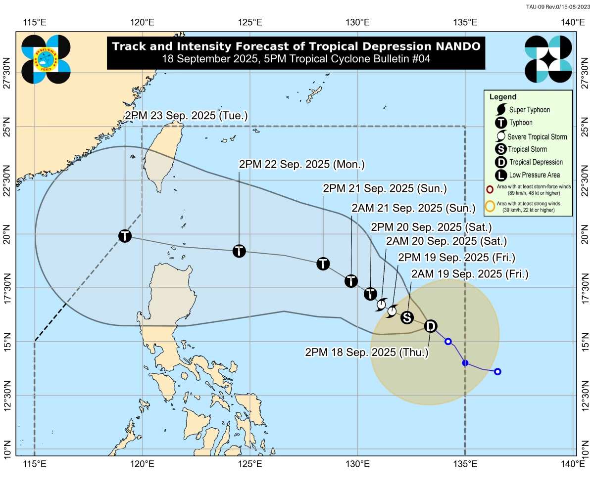
PAGASA said “Nando” could intensify into a typhoon—and potentially a super typhoon—as it nears Northern Luzon in the coming days. (PAGASA)
Based on PAGASA’s forecast track, Nando may pass close to or make landfall over the Babuyan Islands between Sunday, September 21, and Monday, September 22.
“On the forecast track, the center of Nando may pass close to or may make landfall over the Babuyan Islands,” PAGASA added.
Nando is also expected to reach typhoon strength by Saturday and may further intensify into a super typhoon as it crosses Extreme Northern Luzon.
Wind signals and heavy rains expected
Although Nando is not expected to directly affect the country’s weather in the next 48 hours, its interaction with the southwest monsoon may bring heavy rainfall to Northern Luzon starting Sunday.
PAGASA said TCWS No. 1 could be raised over Northern Luzon as early as Saturday, September 20, with the possibility of Signal No. 5 if Nando reaches super typhoon status.
Gusty conditions are expected over the Babuyan Islands, Ilocos Norte, Ilocos Sur, La Union, Pangasinan, and Zambales today, expanding to the rest of the Ilocos Region, Zambales, and Bataan by Friday, September 19.
Meanwhile, PAGASA said moderate to rough seas are forecast over most Luzon coastal waters starting Sunday, September 22, with wave heights possibly reaching up to 14 meters near Extreme Northern Luzon as “Nando” approaches.
The agency urged small vessels not to venture into the sea due to hazardous conditions.
‘Mirasol’ exits PAR, wind signal lifted
Meanwhile, Tropical Depression Mirasol exited the Philippine Area of Responsibility (PAR) earlier today and is moving west-northwest toward southern China.
It was last spotted 395 km west of Calayan, Cagayan, with maximum sustained winds of 55 km/h and gusts of 70 km/h, based on PAGASA’s 11 a.m. bulletin.
While all wind signals have been lifted, PAGASA said “Mirasol” continues to enhance the southwest monsoon, bringing strong to gale-force gusts over parts of Luzon, MIMAROPA, the Bicol Region, and Western Visayas through Saturday, September 20.
Moderate seas up to 2 meters are also expected over the seaboards of Northern Luzon and western Pangasinan, it added.
RELATED STORY: