


Manila Bulletin
 Philippines
National
PAGASA: 'Mirasol' may develop into tropical storm before exiting PAR
Philippines
National
PAGASA: 'Mirasol' may develop into tropical storm before exiting PAR
Philippines
National
PAGASA: 'Mirasol' may develop into tropical storm before exiting PAR
PAGASA: 'Mirasol' may develop into tropical storm before exiting PAR
Signal No. 1 remains in effect across several areas
Published Sep 17, 2025 05:56 am


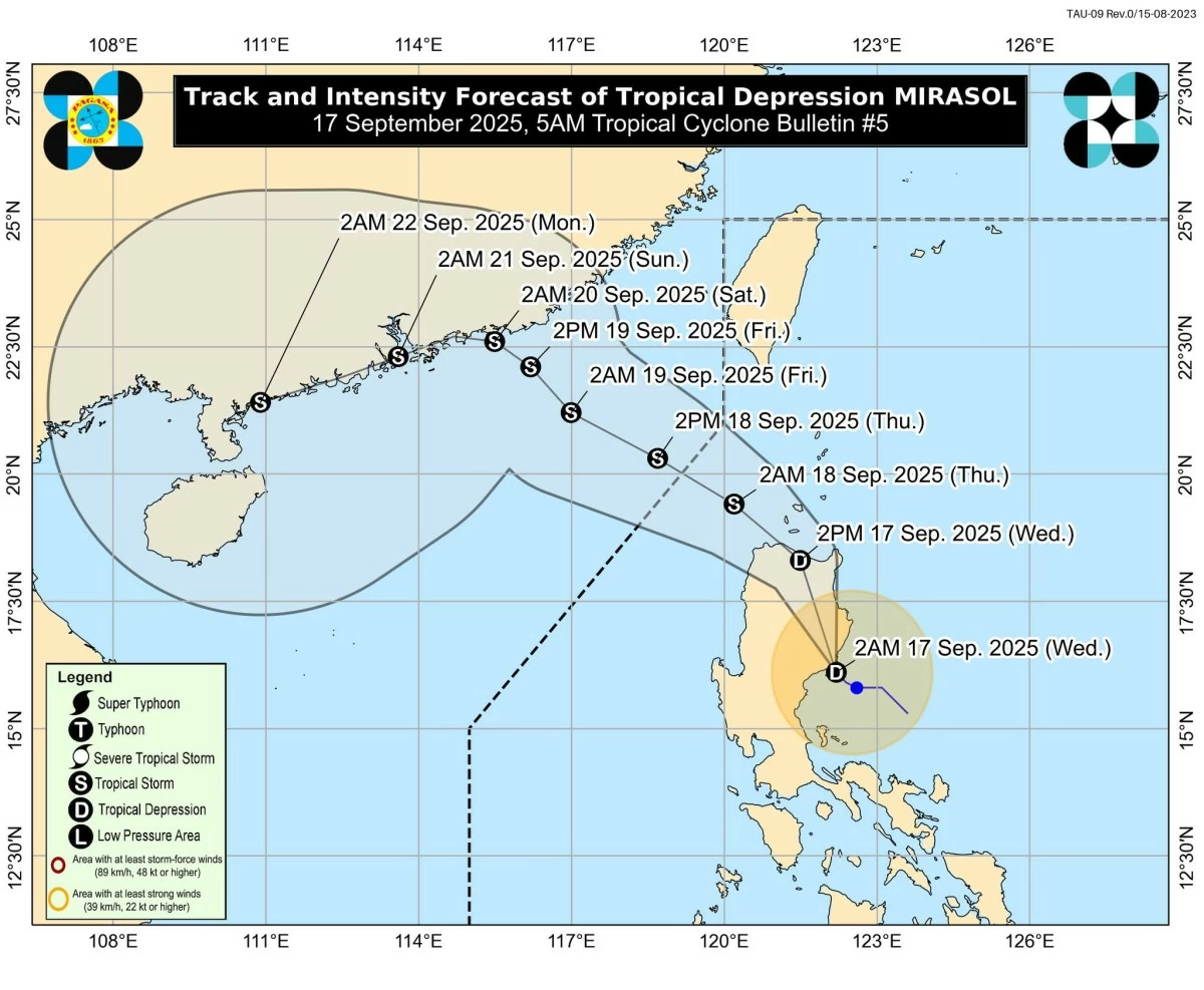
Tropical Depression Mirasol makes landfall in Aurora, likely to intensify into a tropical storm over the Luzon Strait. (PAGASA)
Tropical Depression Mirasol is expected to strengthen into a tropical storm as it moves over the Luzon Strait after making landfall in Aurora, the Philippine Atmospheric, Geophysical, and Astronomical Services Administration (PAGASA) said on Wednesday, September 17.
In its 5 a.m. bulletin, PAGASA reported that TD Mirasol made landfall over Casiguran, Aurora, moving northwestward at 10 km/h with maximum sustained winds of 55 km/h and gusts up to 70 km/h.
Forecast: Possible intensification
PAGASA said “Mirasol” may develop into a tropical storm before exiting the Philippine Area of Responsibility (PAR) on September 18. Stronger winds and heavy rainfall are expected, especially in Northern Luzon.
Areas under Tropical Cyclone Wind Signal No. 1
Strong winds from Mirasol, extending up to 200 km from its center, prompted PAGASA to raise TCWS No. 1 in these areas:
-Batanes
- Cagayan (including Babuyan Islands)
- Isabela
- Quirino
- Nueva Vizcaya
- Northern and central Aurora (Dilasag, Casiguran, Dinalungan, Dipaculao, Baler, Maria Aurora, San Luis)
- Apayao
- Abra
- Kalinga
- Mountain Province
- Ifugao
- Northern and eastern Benguet (Bakun, Mankayan, Kabayan, Buguias, Kibungan, Atok, Bokod)
- Ilocos Norte
- Ilocos Sur
- Polillo Islands
PAGASA warned residents of minimal to minor impacts from strong winds.
Signal No. 2 possible
PAGASA said “Mirasol” is expected to weaken slightly while crossing Northern Luzon but could reintensify into a tropical storm over the Luzon Strait later today, September 17.
If this occurs, Signal No. 2 may be hoisted over parts of Northern Luzon, signaling stronger winds and higher risks.
PAGASA also noted the possibility of further strengthening into a severe tropical storm.
‘Habagat’ to bring gale-force gusts, coastal warnings
Meanwhile, PAGASA said the southwest monsoon (habagat) will continue to bring strong to gale-force gusts in coastal and upland areas of Quezon, Camarines Norte, Camarines Sur, Marinduque, Romblon, Occidental and Oriental Mindoro, Palawan, Panay, Guimaras, Negros Occidental, and Metro Manila in the coming days.
PAGASA said coastal waters remain moderate to rough, with waves up to 3 meters along the eastern seaboards of Cagayan and Isabela, and up to 2.5 meters in Batanes, Babuyan Islands, Aurora, and northern Ilocos Norte.
Mariners of small vessels are advised to take precautions and avoid sailing, if possible, PAGASA said.
RELATED STORY: