


 Philippines
Luzon
Maguindanao del Sur town seeks nat'l govt help in mitigating perennial flood
Philippines
Luzon
Maguindanao del Sur town seeks nat'l govt help in mitigating perennial flood
Maguindanao del Sur town seeks nat'l govt help in mitigating perennial flood


PAGALUNGAN, Maguindanao del Sur – The Municipal Disaster Risk Reduction and Manage Office is appealing to the national government to hasten the implementation of mitigating measures to address the adverse impacts of perennial flooding.

ALIP (Keith Bacongco)
MDRRMO chief Benjamin Alip said that they are still awaiting concerned government agencies to assist them in addressing the issue almost two months since the severe flooding hit.
Alip said that one of their most immediate concerns is the protection of the banks of Pulangi River in Barangay Layog.
Over the years, a large portion of the bank has been scoured due to frequent swelling of the river spawned by heavy rains.
The swelling of the river is oftentimes the main cause of flooding of low-lying areas here, Alip said.
The continued scouring threatens to cut off a portion of the Cotabato-Davao Highway Barangay Layog, he added.
“The main priority now is to protect the highway from scouring. Otherwise, time will come and the river will eventually cut off the highway and it will have an adverse impact not just on our local economy but in our neighboring towns,” said Alip.
Years of scouring on the riverbank have left about 10 meters of soil from the edge of the Pulangi River to the edge of the road pavement.
Alip recalled that there used to be a big concrete house that sits between the highway and the edge of the riverbank.
“Ngayon, wala na. Nasira na rin ang mga bahay diyan dahil sa scouring.” (The house is gone. The houses were destroyed due to scouring)
The MDRRMO chief urged the national government to build more river walls as well as strengthen the existing dikes to mitigate the impact of the swelling of the river.
“Since I assumed as MDRMMO officer 10 years ago, only 200 meters of river wall have been built to protect the highway. And the scouring continues in other parts of the river.”
Almost two months after the severe flooding last July, the MDRRMO official said that concerned government agencies have yet to reach out to the local government to craft mitigating measures on perennial flooding.
The widespread flooding was the worst in this town’s history and has affected at least 11,523 families.
Aside from the heavy rains in the area, the massive flooding was aggravated by the release of water from the Pulangi IV hydroelectric power plant dam in Maramag, Bukidnon.
Pulangi River flows from its headwaters in Bukidnon down to the 220,000-hectare Ligawasan Marsh. The marsh drains to the Moro Gulf through the Rio Grande de Mindanao, which cuts across several towns in Maguindanao del Sur.
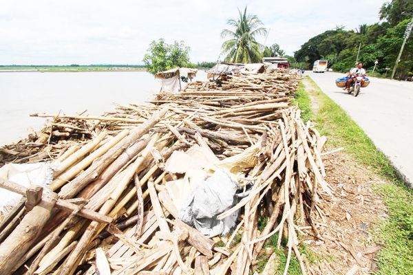
A PILE of driftwood separates the Cotabato-Davao Highway and Pulangi River in Pagalungan, Maguindanao. (Keith Bacongco)
A report from the BARMM Rapid Emergency Action on Disaster Incidence (Bangsamoro READi) showed that severe flooding has affected over 135,000 families or about 600,000 persons from the provinces of Basilan, Lanao del Sur, Maguindanao del Norte, Maguindanao del Sur, and Special Geographic Area (SGA).
Perennial flooding in this town could be attributed to the accumulation of silt in waterways, said Alip.
While admitting that they have experienced flooding in the past, Alip recounted that it was the first time that the flooding started from the Ligawasan Marsh area.
“I was surprised that a barangay official downstream reported to me that it was already flooding downstream while it was still normal in Barangay Layog, which is already beside Pulangi River.”
It turned out that floodwaters have back flowed, he added. “There are times that it’s not raining here but some of our low-lying areas are flooded because it is raining in Bukidnon and resulted in the swelling of Pulangi River.”
Based on their records, Alip disclosed that over 1,200 hectares of land have become marshy due to years of flooding.
One of the worst-hit barangays is Dalgan, Alip said, adding some parts of the barangay are now covered with silt, which is estimated to be about eight meters high.
“In the past, when I would come to Dalgan, I have to climb a tree to be able to see Fort Pikit. But today, I don't have to climb a tree anymore. I can see Fort Pikit by just standing on the silt,” referring to the town hall that sits on top of a hill in Barangay Fort Pikit in Pikit, Cotabato.
Based on estimated aerial distance using Google Maps, Dalgan is about 20 kilometers away from Fort Pikit.
Aside from Dalgan, some parts of the riverside communities in Barangays Bagoinged, Inug-ug, and Kudal have turned into marshland due to perennial flooding.
According to some residents, many of them in the submerged areas have relocated to safer grounds.
“The water in Pulangi River could no longer flow down to the Ligawasan Marsh, which is supposed to be the catch basin, due to siltation. Thus, some parts of the riverside communities are now submerged or marshy,” Alip said.
In the past, he added, his hometown experienced massive displacement due to wars. "But today we are facing just two problems: Drought and flooding."
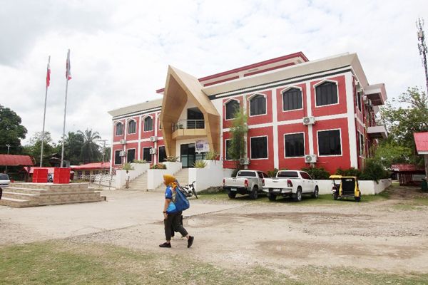
THE new Pagalungan town hall. (Keith Bacongco)
Pagalungan, a former conflict-affected area, is one of the municipalities that sits within the Mindanao River Basin that spreads across Bukidnon, Davao del Norte, Lanao del Sur, Maguindanao, Sultan Kudarat, North Cotabato, South Cotabato, and some parts of Agusan del Sur and chartered cities Cotabato City and Davao City.
The Mindanao River Basin is the second largest river basin in the Philippines with a total area of 21,503-square kilometers and is the second largest river system in the Philippines next to the Cagayan River in Luzon.
One of the solutions that the local government is suggesting is to desilt the waterways to restore the natural flow of the river, Alip said.
However, he admitted that the local governments cannot afford to implement the measure since it will require huge amount of resources.
Collected silt could be used as filling for dikes or river walls, he proposed.
Thus, while the proposed mitigating measures have yet to be implemented, Alip said the communities in low-lying areas have no other choice but to adapt to the situation.
“Pagalungan is already a low-lying town. Thus, when we built the public market area, we dumped hundreds of loads of soil to elevate the site. Same with our new town hall, we elevated the floor area for about two meters.”
During the flooding last July, the entire municipal hall compound was submerged in a meter-deep floodwater for the first time, he said. “So if the floodwaters breach the floor of our town hall, it means that the entire Pagalungan and Pikit would be underwater.”