'Know your hazards': Enhancing disaster preparedness with real-time flood maps from UPRI-UP NOAH Center
As relentless rains from Typhoon Carina (international name: Gaemi) transformed many streets into rivers on Wednesday, July 24, the need for effective disaster preparedness has never been more critical.

In the Philippines, where typhoons and heavy rains are frequent, timely and precise information about flood risks can be crucial for survival.
One of the vital tools for aiding communities and authorities in preparing for and responding to floods is the real-time flood map provided by the UPRI (University of the Philippines Resilience Institute) - UP Nationwide Operational Assessment of Hazards (NOAH) Center.
Real-time monitoring
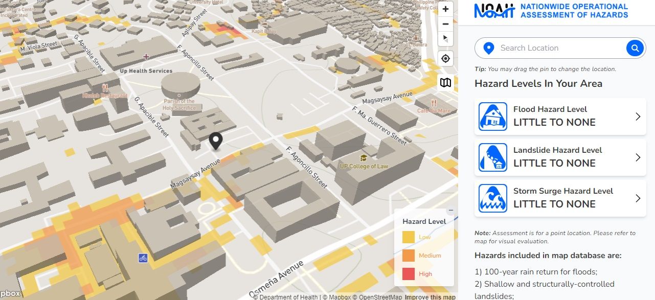
The map, available at https://noah.up.edu.ph/know-your-hazards offers comprehensive details on flood-prone areas as well as safe zones.
This tool allows users to assess the flood susceptibility of their areas.
By evaluating the likelihood of floods, landslides, and storm surges, individuals can understand the risks and take appropriate measures to prepare effectively.
The map provides real-time, detailed information on flood conditions throughout different regions in the Philippines.
By integrating data from rainfall measurements, river gauges, and other meteorological sources, the map offers an up-to-date overview of flood risks, enabling users to make informed decisions.
Key features
Designed for user accessibility, the map features a user-friendly interface that simplifies navigation and data interpretation.
It also integrates real-time data from multiple sources, including weather forecasts.
This real-time approach ensures that users receive the most current information available.
Users simply enter their location, and the map will evaluate hazard levels for that area, including flood, landslide, and storm surge risks.

Hazard levels are categorized as low, medium, or high. By clicking on the “hazard level,” users can access additional information, including “what to do” and “survival tips.”
The map database includes hazards such as 100-year rain return for floods, shallow and structurally controlled landslides, and storm surges up to 5 meters.
According to UP NOAH, these hazard levels are based on "flood simulations, satellite data, and historical records."
The map provides detailed visualizations that show the extent and depth of flooding in affected areas, helping users understand the severity of flooding and its potential impact on communities.
Supporting disaster preparedness and response
By offering real-time updates and alerts, the map enhances early warning systems, giving communities and authorities more time to prepare and take necessary actions before floods occur.
The map also provides accurate flood data, assisting local governments and emergency responders in making informed decisions regarding evacuations, resource allocation, and response strategies.
Additionally, the map empowers individuals with crucial information, enabling them to assess their own risk and take proactive measures to protect their homes and families.
Most importantly, the map assists in risk management by providing historical data and flood trends. This information supports long-term risk management and urban planning, helping to mitigate the impacts of future floods.
By providing real-time, actionable information, the map plays a crucial role in helping communities stay informed and resilient in the face of flooding.
Properly utilized, the UPRI-UP NOAH Center Real-Time Flood Map represents a significant advancement in flood management and disaster preparedness in the Philippines.