


Cotabato governor seeks help vs flooding in Central Mindanao


By KEITH BACONGCO
DAVAO CITY – Cotabato Gov. Emmylou Taliño-Mendoza has urged the national government as well as concerned government agencies to assist in addressing the perennial flooding in Central Mindanao.
Mendoza suggested to the concerned government agencies to refer to the Climate-Responsive Integrated Master Plan for Mindanao River Basin in implementing any flood mitigation projects.
The governor issued the appeal following the widespread flooding caused by heavy rains that submerged many parts of the low-lying barangays in Kabacan and Pikit and some parts of the neighboring Datu Montawal and Pagulangan towns in Maguindanao del Sur province.

A RESCUER lifts an elderly woman during a rescue operation in a flooded area in Barangay Cuyapon, Kabacan, North Cotabato on Tuesday, July 16. (LGU Kabacan)
According to Mendoza, the study, which was released in 2015, was a product of years of study that include some recommendations on flood mitigation, disaster risk reduction, and hazards management.
Mendoza added that there should be a comprehensive approach among the local governments inside the Mindanao River Basin in addressing the flood problem.
She added that she has yet to meet different government agencies to iron out things in resolving the perennial flooding not just in her province but as well as in neighboring provinces.
Mindanao River Basin
The study on the Mindanao River Basin was conducted by the College of Forestry and Natural Resources University of the Philippines-Los Baños and was funded by the River Basin Control Office under the Department of Environment and Natural Resources.
According to the document, it was one of the studies conducted in all 18 major river basins in the country. It was formulated in 2012 and was subsequently approved by respective Regional Development Councils.
It stated that the Mindanao River Basin spreads across the provinces of Bukidnon, Davao del Norte, Lanao del Sur, Maguindanao, Sultan Kudarat, North Cotabato, South Cotabato and some parts of Agusan del Sur and chartered cities Cotabato City and Davao City.
The Mindanao River Basin is the second largest river basin in the Philippines with a total area of 21,503-square kilometers and is the second largest river system in the Philippines next to Cagayan River in Luzon.
It is also the second longest river in the country with an approximate length of 373 kilometers.
Its headwaters can be found in Impasug-ong in Bukidnon, where it is known as the Upper Pulangui River; going downstream, it then joins with Kabacan River, where it is now called Mindanao River.
The study added that the Lower Pulangui, in its lower portion, drains in Ligawasan Marsh, which drains through Rio Grande de Mindanao and Tamontaka River towards the Moro Gulf on the western part of Mindanao.
The Mindanao River Basin’s major tributaries include the Kabacan, Libungan, Malitbog, and Maridagao Rivers in Cotabato; Kulaman River in Bukidnon, which constitutes the northern part of the river basin and then the southern part includes the rivers Allah, Banga (South Cotabato), and Buluan (Maguindanao del Sur).
Silted waterways
Over the years, flooding in the low-lying towns of Maguindanao del Norte, Maguindanao del Sur, Cotabato, and South Cotabato was attributed to the swelling of these river systems.
A report from the Mindanao Development Authority stated that “the physiography of Mindanao River Basin renders it highly susceptible to flooding, with its denuded mountain regions unable to retard rapid runoff from heavy rainfall.”
It is surrounded by rugged mountain ranges where logging operations were conducted in the 1970s to 1980s.
The report added that the continuous scouring due to swelling of the Pulangui River in Pagalungan may eventually cut off the Davao-Cotabato Highway.
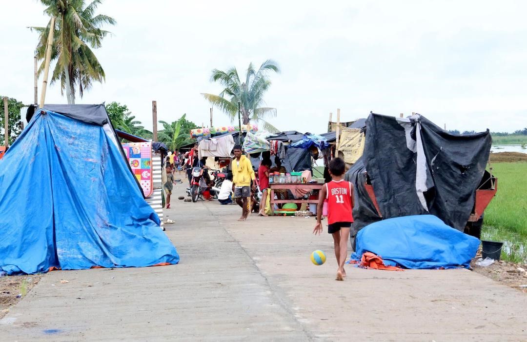
FLOOD victims build makeshift tents in safer grounds in Kabacan, North Cotabato on Tuesday, July 16. (LGU Kabacan)
Residents living near the Pulangui River in Barangay Layog in Pagalungan, Maguindanao del Sur have observed that a large portion of the river bank had been gradually scoured by the river.
In the past, they added, the waterway was just about 30 meters wide. But due to continuous swelling of the river, it has eventually expanded to 50 meters.
Over the weekend, portions of the Cotabato-Davao Highway and the town proper of Pagalungan were submerged in floodwaters due to swelling of the river systems.
The highway was temporarily impassable to light vehicles for a few hours.
Hundreds of residents were rescued from the low-lying areas after they were trapped in their houses.
Even if there’s no rain in Cotabato or Maguindanao, Mendoza said some areas would experience flooding due to the swelling of the Pulangi River.
Many residents lamented that the flooding in these areas is becoming worse.
A resident said that there were floods in the past but water would subside the following day.
Another resident added that floodwaters do not usually breach the national highway. “The waterways are already clogged by too much silt. The water could not flow down to the Ligawasan Marsh anymore. Thus, the rivers swell and submerge the communities along the highway.”
Mendoza blamed the sudden rise of water to the National Power Corp. (Napocor) that allegedly released water from one of its dams in Bukidnon without prior notice – the Pulangi IV Hydroelectric Power Plant in Maramag.
As a result, hundreds of residents in Kabacan and Pikit sought refuge to safer grounds following the sudden surge of water from the Pulangi River over the weekend.
She asked Napocor to inform the local government units on the Pulangi River and low-lying areas if they release water.
The Napocor Mindanao Generation Office in Iligan City was asked to comment and has yet to respond as of posting time.
In Kabacan, the flooding affected 5,185 families from 13 out of 17 barangay, according to a report from the local government. At least 1,000 hectares of agricultural land was hit by the flooding.
Almost 14,900 families have been affected by the flood in 17 of the 20 barangays in Pikit.
Aside from barangays in Cotabato, several under the newly created towns of the Special Geographic Area of the Bangsamoro Autonomous Region in Muslim Mindanao (BARMM) have been hit by flooding.
Mendoza said years of flooding have accumulated so much silt in the waterways going in and out of the Ligawasan Marsh.
Thus, the study on Mindanao River Basin can be a useful guide among the local government units in the region to properly implement appropriate mitigating measures, she added.
For instance, the governor said, desilting cannot be done alone by a single LGU adding that it might result in flooding in neighboring areas that have not desilted its waterways.
She suggested that there must be a comprehensive effort to desilt the waterways, including parts of Ligawasan Marsh, to bring back the natural course of water in river systems.
“There must be a scientific approach in addressing this problem. And we cannot do this alone, we need the help of the national government.”