


Why Davao is suffering from massive flooding


DAVAO CITY – An environmental group has attributed the widespread flooding and landslides in the Davao region to the diminishing forest cover, massive land conversion, and poor urban planning.
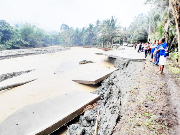
RESIDENTS gather beside a destroyed road in San Isidro, Davao Oriental. (Contributed photo)
Interfacing Development Interventions for Sustainability Executive Director Mark Peñalver said that it is no longer surprising that many landslides were reported, especially in Davao Oriental, given the situation of the forests in the region.
Peñalver said that what is happening right now in the lowlands is mainly because of the aggressive human activities in the uplands, especially in the remaining forests.
While he acknowledged that the government has been implementing a lot of mitigating measures in the lowlands, the environmental lawyer added there’s almost nothing being done in the uplands.
Peñalver theorized that some flood-mitigating infrastructures may not be appropriate enough to address the perennial flooding.
In urban areas, he said, massive real estate development and land conversions may have contributed to the severe flooding.
He cited the perennial flooding problem in one of the subdivisions in this city that sits on the old riverbed of the Davao River.
Like in the past, a portion of this residential area has been submerged to flood waters whenever the Davao River breaches its banks.
On February 1, over 100 families were forced to evacuate to safer grounds when flood waters rose to almost 10 feet.
Peñalver emphasized the need to protect the remaining wetlands and improve the waterways in urban areas.
Continuous rains since January 30 mainly due to the trough of a low-pressure area swamped many parts of the Davao region.
In this city, flooding has affected about 7,000 people from 10 barangays.
Harbinger of worst things to come
Peñalver noted that adverse impacts of climate change are the harbinger of the worst things to come.
"This could be signs of worsening climate conditions. If we maintain business as usual, i.e., the government continues to allow mining, land conversion without proper planning and consultation, monocrop plantations, then we might be experiencing a prelude to a far worse scenario," he said.
The Davao region has a total land area of at least 20,400-square kilometers. But only a quarter of its land area is covered by forests.
As of 2020, data from the Forest Management Bureau showed that the region’s forest cover is 4,400-square kilometers.
The province of Davao Oriental has the biggest forest cover left with almost 1,800-square kilometers or 180,000 hectares.
The province of Davao del Sur has the lowest forest cover left with 351.29 square kilometers or 35,119 hectares.
According to reports, hardest hit in this most recent natural disaster were Davao Oriental, Davao de Oro, and Davao del Norte. It left several roads and bridges damaged or totally destroyed due to landslides and severe flooding.
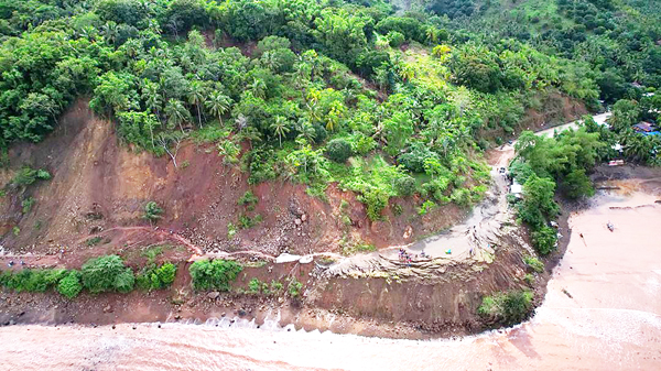
AERIAL photo shows a damaged road due to landslide in Barangay Mamali in the City of Mati, Davao Oriental. (PIO Davao Oriental)
Photos and videos circulated in social media showed that urban areas in these provinces were submerged in raging flood waters.
A portion of national highway in Carmen in Davao del Norte was submerged in floodwaters and was impassable to hauler trucks since February 1.
The closure of the highway left hundreds of motorists stranded and hampered the movement of goods in the region.
Combined reports from the affected provinces said that effects of the trough of the LPA have affected about 120,000 families as of February 2.
The disaster killed six persons and injured seven in Davao de Oro. One person was reported missing in Davao de Oro and two others in a remote village in Tarragona, Davao Oriental.
Office of Civil Defense (OCD)-Davao chief Ednar Dayanghirang said that many parts of Davao Oriental are susceptible to landslides.
Based on the geohazard map of the Mines and Geosciences Bureau, almost the entire mountain areas of Davao Oriental are classified under high susceptibility.
Dayanghirang added that about 70 percent of the topography of the province has steep to very steep slope.
He added that local government units in the region already know about the geohazards down to the purok level but it’s the people who kept on coming back to these supposed no-build zones.
“For example in one area that I have visited, I learned that the residents have already been paid by the government to leave the area because it was declared a no build zone. But they are still living in the area. What can we do?” the OCD official said.
And this is a recurring problem across the country, he added.
Dayanghirang said this problem needs to be addressed comprehensively and not just by the local government units alone. “There should be a dialogue to resolve this. Because in some situations, are not caused by the people but caused by conflicting policies of government agencies.”
While he did not dismiss the adverse impact of logging operations in the past as well as ongoing mining operations in the region, he noted that this weather pattern could be already due to climate change.
Dayanghirang said that it seems that the amount of rainfall is beyond the measuring scale.
The Philippine Atmospheric, Geophysical, and Astronomical Services Administration placed the region under red warning on January 31, which means the amount of rain is than 150,000 drums per square kilometer.
However, the OCD official believes that the amount of rainfall could be over that than the actual estimate.
Dayanghirang admitted that local government units cannot resolve this recurring problem of flooding and landslides, adding that the national government must also intervene.
Peñalver urged the government to review its plans and policies in addressing the impacts of climate change.
“We have to consider our environmental history for us to move forward with more sustainable interventions and planning that are responsive to changing climate conditions and people. That is what the government should do. Invest more on nature-based solutions to mitigate disaster risks and avoid projects or investments that contribute to climate change.”