At A Glance
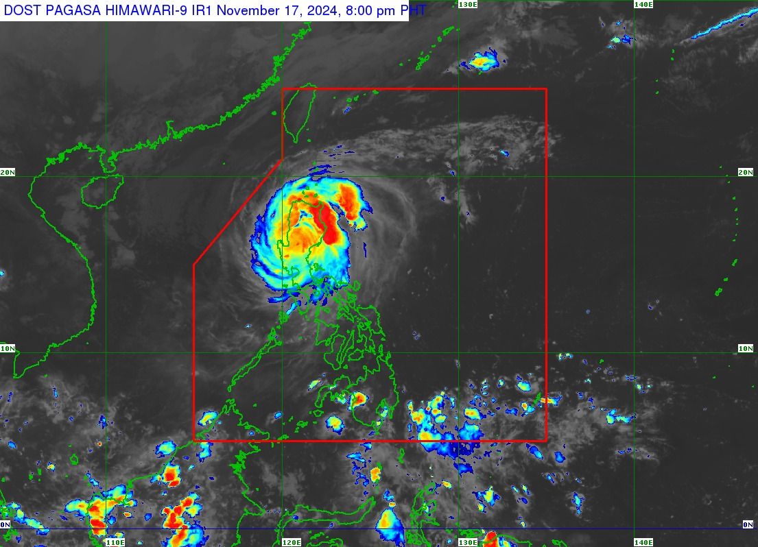
- The center of the typhoon was located over Santa Fe, Nueva Vizcaya at around 7 p.m. Pepito is expected to continue its current track and exit the Luzon landmass via Pangasinan, La Union, or southern Ilocos Sur by late Sunday or early Monday, Nov. 18.
- It is expected to leave the Philippine area of responsibility by Monday morning or noon.
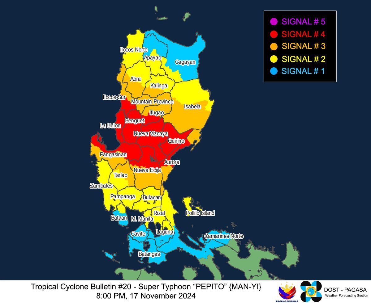
- With the weakening of Pepito, PAGASA has lifted Wind Signal No. 5, but Signal Nos. 4, 3, 2, and 1 remain in effect over several areas in Luzon.

Super Typhoon "Pepito" (international name: Man-yi) has significantly weakened and was downgraded to a typhoon as it continues its west-northwestward movement across Luzon, the Philippine Atmospheric, Geophysical and Astronomical Services Administration (PAGASA) said on Sunday evening, Nov. 17.
READ MORE: https://mb.com.ph/2024/11/17/pepito-makes-2nd-landfall-in-aurora
In its 8 p.m. bulletin, PAGASA said Pepito now has maximum sustained winds of 165 kilometers per hour (kph) near its center and gusts reaching 275 kph. Previously, it had maximum sustained winds of 185 kph and gusts up to 305 kph.
The center of the typhoon was located over Santa Fe, Nueva Vizcaya at around 7 p.m. Pepito is expected to continue its current track and exit the Luzon landmass via Pangasinan, La Union, or southern Ilocos Sur by late Sunday or early Monday, Nov. 18.
It is expected to leave the Philippine area of responsibility by Monday morning or noon.
As Pepito moves out of Luzon, PAGASA said it would continue to weaken due to land interaction. However, despite the significant weakening, it is expected to remain classified as a typhoon until it reaches the West Philippine Sea, where further deterioration is anticipated due to the northeasterly wind surge, which will create unfavorable conditions.

Wind warnings lowered
With the weakening of Pepito, PAGASA has lifted Wind Signal No. 5, but Signal No. 4 remains in effect over the central portion of Aurora (Dinalungan, Dipaculao, Baler, Maria Aurora), Quirino, Nueva Vizcaya, southern portion of Ifugao (Kiangan, Lamut, Tinoc, Asipulo, Lagawe), Benguet, southern portion of Ilocos Sur (Alilem, Sugpon, Suyo, Santa Cruz, Tagudin, City of Candon, Santa Lucia, Salcedo, Galimuyod, Cervantes, Sigay), La Union, northern and eastern portions of Pangasinan (Sison, Tayug, Binalonan, San Manuel, Asingan, San Quintin, Santa Maria, Natividad, San Nicolas, Balungao, Pozorrubio, Laoac, San Jacinto, San Fabian, Manaoag, City of Urdaneta, Rosales, Umingan, Mangaldan, Mapandan, Villasis, Santo Tomas, Dagupan City, Anda, Bolinao, Bani, City of Alaminos, Lingayen, Binmaley, Sual, Labrador), and northern portion of Nueva Ecija (Bongabon, Pantabangan, Rizal, Lupao, San Jose City, Carranglan, Science City of Muñoz, Talugtug, Cuyapo, Llanera). Significant to severe impacts from typhoon-force winds may be felt in these areas.
Signal No. 3 remains raised over the southern portion of Isabela (San Agustin, Jones, Echague, San Guillermo, Angadanan, Alicia, San Mateo, Ramon, San Isidro, City of Santiago, Cordon, Dinapigue, Roxas, Aurora, Cabatuan, City of Cauayan, Luna, San Mariano, Benito Soliven, Naguilian, Reina Mercedes, San Manuel, Burgos), the rest of Ifugao, Mountain Province, southern portion of Kalinga (Pasil, Tanudan, Lubuagan, Tinglayan), southern portion of Abra (Tubo, Luba, Pilar, Villaviciosa, San Isidro, Pidigan, Langiden, San Quintin, Bangued, Manabo, Boliney, Peñarrubia, Bucloc, Sallapadan, Bucay), the rest of Ilocos Sur, the rest of Pangasinan, northern and eastern portions of Tarlac (Paniqui, La Paz, Moncada, City of Tarlac, Gerona, Pura, San Clemente, Santa Ignacia, Victoria, Camiling, Concepcion, Ramos, San Manuel, Anao), the rest of Nueva Ecija, and the rest of Aurora. These areas may experience “moderate to significant impacts” from storm-force winds.
Areas under Signal No. 2 are the rest of Isabela, southwestern portion of mainland Cagayan (Enrile, Tuao, Solana, Tuguegarao City, Piat, Rizal), the rest of Kalinga, southern portion of Apayao (Conner, Kabugao), the rest of Abra, Ilocos Norte, Zambales, the rest of Tarlac, northern portion of Bataan (Orani, Abucay, Hermosa, Samal, Dinalupihan), Pampanga, Bulacan, Metro Manila, Rizal, northeastern portion of Laguna (Kalayaan, Paete, Pangil, Pakil, Siniloan, Famy, Santa Maria, Mabitac), and northern portion of Quezon (General Nakar, Infanta, Real) including Polillo Islands “Minor to moderate impacts” from gale-force winds are possible in these areas.
The rest of mainland Cagayan, the rest of Apayao, the rest of Bataan, Cavite, the rest of Laguna, Batangas, central portion of Quezon (Calauag, Pitogo, Lucena City, Pagbilao, Tiaong, Lopez, Guinayangan, Unisan, Plaridel, Quezon, San Antonio, Alabat, Candelaria, Lucban, Sampaloc, Padre Burgos, Sariaya, City of Tayabas, Macalelon, Mauban, Dolores, Perez, Agdangan, Gumaca, Atimonan, Tagkawayan), Lubang Islands, and western portion of Camarines Norte (Santa Elena, Paracale, Labo, Vinzons, Jose Panganiban, Capalonga) are under Signal No. 1. These areas may experience “minimal to minor impacts” from strong winds.
Storm surges, rough seas
As Pepito remains a powerful tropical cyclone, PAGASA has warned of life-threatening storm surges with peak heights exceeding three meters in low-lying coastal areas in the Ilocos Region, southeastern mainland Cagayan, Isabela, Central Luzon, Metro Manila, Cavite, and Quezon province.
A gale warning is also in effect over the eastern seaboard of Luzon and western seaboards of Northern and Central Luzon due “very rough” or “very high” seas.

Heavy rainfall
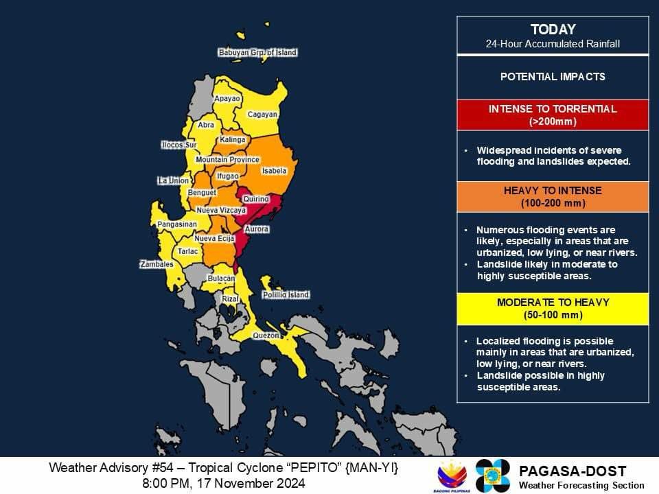
In the next 24 hours, PAGASA said intense to torrential rainfall (over 200) may persist in Aurora and Quirino, which could lead to widespread flooding and landslides.
Heavy to intense rainfall (100 to 200 millimeters) is also expected over Nueva Ecija, Benguet, Ifugao, Kalinga, Mountain Province, Nueva Vizcaya, and Isabela. PAGASA said “numerous flooding events” are possible, especially in urbanized, low-lying, or river-adjacent areas. Landslides are also likely in areas with “moderate to high” susceptibility.
Moderate to heavy rainfall (50 to 100 millimeters) is expected in Bulacan, Pangasinan, Cagayan, Apayao, Abra, Ilocos Sur, La Union, Quezon, Rizal, Tarlac, and Zambales, where localized flooding and landslides are possible.
PAGASA advised residents in affected areas to remain vigilant, as Pepito continues to pose a significant threat to lives, properties, and infrastructure.