'Pepito' makes 2nd landfall in Aurora, moves across mainland Luzon
At A Glance
- Super Typhoon "Pepito" (international name: Man-yi) made its second landfall over Dipaculao, Aurora at 3:20 p.m. on Sunday, Nov. 17, and is now moving across mainland Luzon.
- PAGASA emphasized that heavy rainfall, severe winds, and storm surges may still affect areas outside the landfall area.

Super Typhoon “Pepito” (international name: Man-yi) made its second landfall over Dipaculao, Aurora at 3:20 p.m. on Sunday, Nov. 17, and is now moving across mainland Luzon, said the Philippine Atmospheric, Geophysical and Astronomical Services Administration (PAGASA).
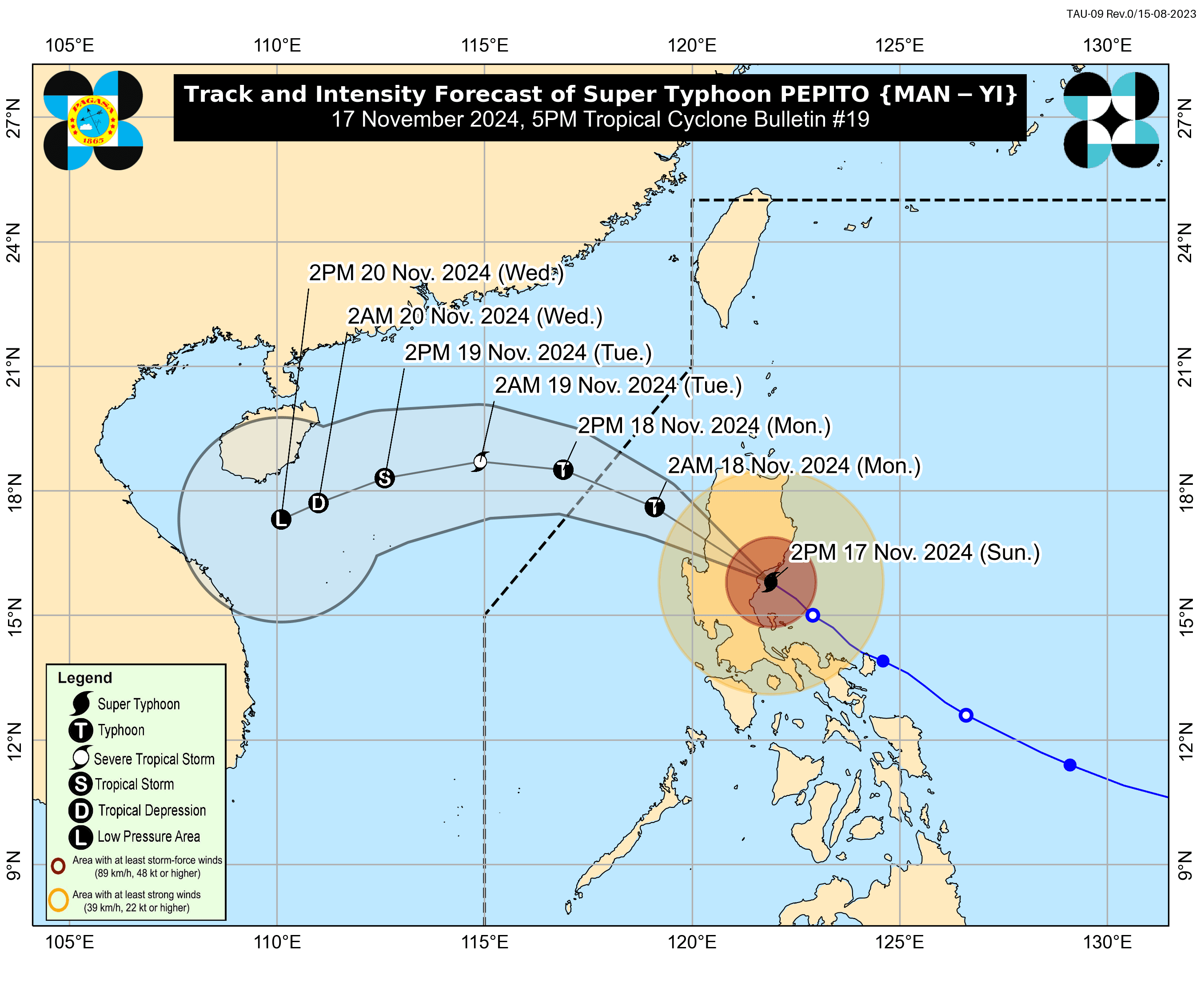
In its 5 p.m. bulletin, PAGASA said Pepito was located over Nagtipunan, Quirino while packing maximum sustained winds of 185 kilometers per hour (kph) near its center and gusts soaring to 305 kph.
It first made landfall over Panganiban, Catanduanes at 9:40 p.m. on Saturday, Nov. 16.
PAGASA emphasized that heavy rainfall, severe winds, and storm surges may still affect areas outside the landfall point and forecast confidence cone.
Severe winds
Signal No. 5 has been hoisted over the central portion of Aurora (Dipaculao, Baler, Dinalungan, Maria Aurora, Casiguran, San Luis), southern portion of Quirino (Nagtipunan), and southern portion of Nueva Vizcaya (Alfonso Castañeda, Dupax del Norte, Dupax del Sur, Kasibu, Aritao, Bambang), where extreme impacts from typhoon-force winds are expected.
Signal No. 4 is in effect over the rest of Aurora, the rest of Nueva Vizcaya, the rest of Quirino, southern portion of Ifugao (Kiangan, Lamut, Tinoc, Asipulo, Lagawe), Benguet, southern portion of Ilocos Sur (Alilem, Sugpon, Suyo, Santa Cruz, Tagudin), La Union, eastern portion of Pangasinan (Sison, Tayug, Binalonan, San Manuel, Asingan, San Quintin, Santa Maria, Natividad, San Nicolas, Balungao, Pozorrubio, Laoac, San Jacinto, San Fabian, Manaoag, City of Urdaneta, Rosales, Umingan, Mangaldan, Mapandan, Villasis, Santo Tomas), and northern portion of Nueva Ecija (Gabaldon, Laur, Bongabon, Pantabangan, Rizal, General Mamerto Natividad, Lupao, San Jose City, Llanera, Carranglan, Science City of Muñoz, Talugtug, Cuyapo). Significant to severe impacts from typhoon-force winds may be felt in these areas.
Signal No. 3 also remains raised over the southern portion of Isabela (San Agustin, Jones, Echague, San Guillermo, Angadanan, Alicia, San Mateo, Ramon, San Isidro, City of Santiago, Cordon, Dinapigue, Roxas, Aurora, Cabatuan, City of Cauayan, Luna, San Mariano, Benito Soliven, Naguilian, Reina Mercedes, San Manuel, Burgos), the rest of Ifugao, Mountain Province, southern portion of Kalinga (Pasil, Tanudan, Lubuagan, Tinglayan), southern portion of Abra (Tubo, Luba, Pilar, Villaviciosa, San Isidro, Pidigan, Langiden, San Quintin, Bangued, Manabo, Boliney, Peñarrubia, Bucloc, Sallapadan, Bucay), the rest of Ilocos Sur, the rest of Pangasinan, northern and eastern portions of Tarlac (Paniqui, La Paz, Moncada, City of Tarlac, Gerona, Pura, San Clemente, Santa Ignacia, Victoria, Camiling, Concepcion, Ramos, San Manuel, Anao), the rest of Nueva Ecija, northern portion of Bulacan (Doña Remedios Trinidad, San Miguel), and northern portion of Quezon (Infanta, General Nakar) including Polillo Islands. These areas may experience “moderate to significant impacts” from storm-force winds.
Areas under Signal No. 2 are the rest of Isabela, southwestern portion of mainland Cagayan (Enrile, Tuao, Solana, Tuguegarao City, Piat, Rizal), the rest of Kalinga, southern portion of Apayao (Conner, Kabugao), the rest of Abra, Ilocos Norte, Zambales, the rest of Tarlac, northern portion of Bataan (Orani, Abucay, Hermosa, Samal, Dinalupihan), Pampanga, the rest of Bulacan, Metro Manila, Rizal, northeastern portion of Laguna (Santa Cruz, Pila, Mabitac, Paete, Pagsanjan, Pangil, Santa Maria, Siniloan, Cavinti, Kalayaan, Lumban, Pakil, Famy), and central portion of Quezon (Sampaloc, Mauban, Perez, Real). “Minor to moderate impacts” from gale-force winds are possible.
The rest of mainland Cagayan, the rest of Apayao, the rest of Bataan, Cavite, the rest of Laguna, Batangas, the rest of Quezon, northern portion of Occidental Mindoro (Abra de Ilog, Paluan) including Lubang Islands, northern portion of Oriental Mindoro (Puerto Galera, San Teodoro, Naujan, Baco, City of Calapan), Marinduque, Camarines Norte, and northern portion of Camarines Sur (Libmanan, Tinambac, Siruma, Cabusao, Canaman, Magarao, Calabanga, Bombon, Sipocot, Ragay, Del Gallego, Lupi, Lagonoy, Goa, Garchitorena, Pasacao, Pamplona, Camaligan, Gainza). These areas may experience “minimal to minor impacts” from strong winds.
Flood risks continue
Over the next 24 hours, PAGASA warned of intense to torrential rainfall (over 200) over, Aurora, Quirino, Nueva Vizcaya, Ifugao, and Pangasinan, which could lead to widespread flooding and landslides.
Heavy to intense rainfall (100 to 200 millimeters) is also expected over Quezon, Isabela, Mountain Province, Kalinga, Benguet, Abra, Nueva Ecija, La Union, Zambales, Bulacan, and Rizal. PAGASA said “numerous flooding events” are possible, especially in urbanized, low-lying, or river-adjacent areas. Landslides are also likely in areas with “moderate to high” susceptibility.
Moderate to heavy rainfall (50 to 100 millimeters) is expected in Metro Manila, Ilocos Sur, Bataan, Tarlac, Pampanga, and Laguna, where localized flooding and landslides are possible.
PAGASA advised residents in affected areas to remain alert, as Pepito continues to pose a significant threat to lives, properties, and infrastructure.
Forecast track, intensity
After its second landfall, PAGASA said Pepito will move across the northern portion of Central Luzon and southernportion of Northern Luzon, passing through the upland regions of the Sierra Madre, Caraballo, and Cordillera Central between Sunday afternoon and evening.
The typhoon is expected to exit the Luzon landmass by Sunday evening or early Monday, Nov. 18. It may exit the Philippine area of responsibility by Monday morning or noon.
As Pepito exits the Luzon landmass, PAGASA said it will significantly weaken due to land interaction.
Further weakening is expected over the West Philippine Sea, where the northeasterly wind surge will create unfavorable conditions.