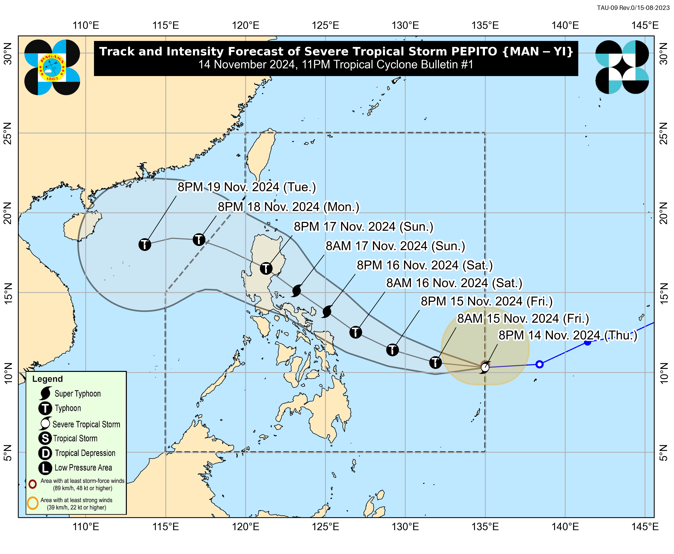
'Pepito' may make landfall as a super typhoon; Signal No. 5 possible
At A Glance
- Severe Tropical Storm Pepito may intensify into a typhoon by Friday, Nov. 15, and reach super typhoon strength by Saturday afternoon or evening, Nov. 16, just before landfall.
- Pepito may make landfall along the eastern coast of Central Luzon between Nov. 16 and 17.
- While it is still too early to pinpoint specific areas at risk, PAGASA of heavy rainfall, strong winds, and possible storm surges in "most areas in Luzon and Eastern Visayas."

The Philippine Atmospheric, Geophysical and Astronomical Services Administration (PAGASA) warned on Thursday, Nov. 14 that Severe Tropical Storm “Pepito” (international name: Man-yi) could intensify into a super typhoon before making landfall over Central Luzon this weekend.
This comes as Typhoon “Ofel” (international name: Usagi) continues to batter extreme Northern Luzon and remains inside the Philippine area of responsibility (PAR).
In its 11 p.m. bulletin, PAGASA said the center of Pepito was located 945 kilometers east of Eastern Visayas, with maximum sustained winds of 100 kilometers per hour (kph) near its center and gusts reaching 125 kph.
PAGASA said Pepito may intensify into a typhoon by Friday, Nov. 15, and reach super typhoon strength by Saturday afternoon or evening, Nov. 16, just before landfall.
Due to land interaction, however, the cyclone may weaken into a typhoon by Sunday evening after crossing the landmass and exiting the PAR on Monday, Nov. 18.
PAGASA said the high-pressure area south of Japan is steering Pepito westward over the next 24 hours. The storm may gradually shift to a west-northwestward to northwestward path over the Philippine Sea, passing close to Eastern Visayas and Bicol Region.
Its forecast track shows that Pepito may make landfall along the eastern coast of Central Luzon between Nov. 16 and 17.
However, PAGASA said the exact landfall point remains uncertain, as the track could shift within the forecast confidence cone, especially for the projection for the third and fourth days
“Therefore, the landfall point may also shift within the range of the forecast confidence cone from the eastern coast of Central Luzon to the eastern coast of Eastern Visayas,” it added.
While it is still too early to pinpoint specific areas at risk, PAGASA warned that Pepito could bring heavy rainfall, strong winds, and possible storm surges to “most areas in Luzon and Eastern Visayas.”
As of Thursday evening, PAGASA raised Wind Signal No. 1 over Catanduanes, eastern portion of Camarines Sur (Caramoan, Garchitorena, Presentacion, San Jose, Lagonoy), eastern portion of Albay (Rapu-Rapu, City of Tabaco, Malilipot, Santo Domingo, Bacacay, Legazpi City, Malinao, Manito, Tiwi), eastern and southern portions of Sorsogon (Juban, City of Sorsogon, Barcelona, Bulusan, Magallanes, Gubat, Santa Magdalena, Casiguran, Bulan, Irosin, Matnog, Prieto Diaz), Northern Samar, northern portion of Eastern Samar (San Policarpo, Arteche, Jipapad, Maslog, Dolores, Oras), and northeastern portion of Samar (Matuguinao, San Jose de Buan).
PAGASA also warned that Signal No. 5 could be issued during the passage of Pepito.
Its heavy rainfall outlook showed that heavy to intense rainfall (100 to 200 millimeters) may affect Catanduanes, Northern Samar, Eastern Samar, and Sorsogon from Friday evening to Saturday evening. “Numerous flooding events are likely, especially in urbanized and low-lying areas or near rivers. Likewise, landslides are possible in areas with moderate to high susceptibility.
Moderate to heavy rainfall (50 to 100 millimeters) may also affect Camarines Norte, Camarines Sur, Albay, Leyte, Biliran, and Samar. Localized flooding is possible, especially in urbanized and low-lying areas, or near rivers. Landslides are possible in highly vulnerable areas.
From Saturday evening to Sunday evening, intense to torrential rainfall (more than 200 millimeters) may affect Quezon, Aurora, Camarines Norte, Camarines Sur, and Catanduanes. Widespread incidents of severe flooding and landslides are expected.
In addition, heavy to intense rainfall may persist in Northern Samar, Albay, Sorsogon, Marinduque, Laguna, Rizal, Bulacan, Nueva Ecija, and Aurora.
Moderate to heavy rainfall may affect Metro Manila, Bataan, Cavite, Zambales, Tarlac, Batangas, Pampanga, Leyte, Masbate, Romblon, Eastern Samar, Samar, Biliran, Pangasinan, Nueva Vizcaya, and Quirino.