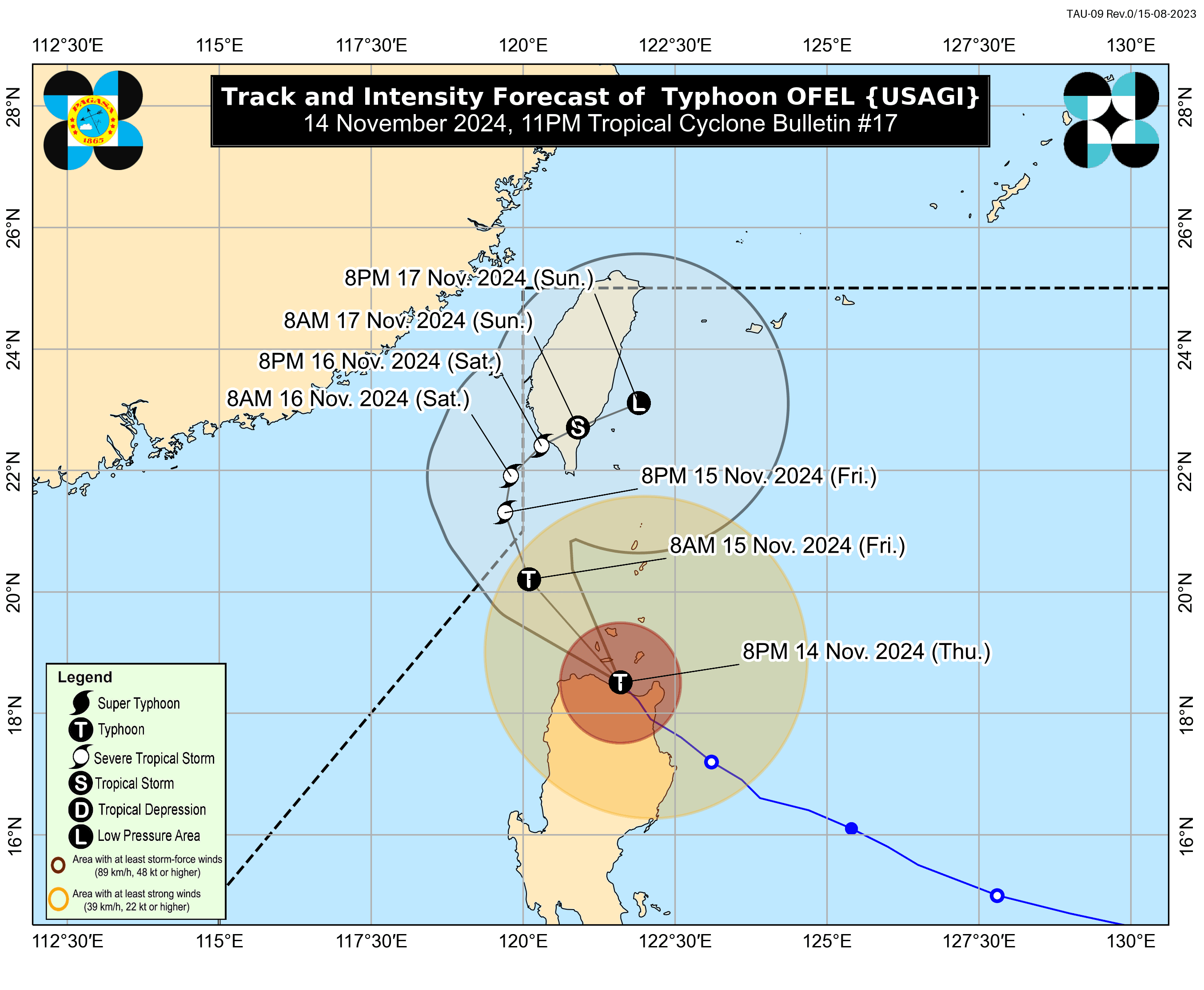
'Ofel' further weakens as it traverses Babuyan Islands; Signal No. 4 still up

The Philippine Atmospheric, Geophysical and Astronomical Services Administration (PAGASA) said Typhoon “Ofel” (international name: Usagi) has further weakened as it moved over the Babuyan Islands on Thursday evening, Nov. 14.
According to PAGASA’s 11 p.m. bulletin, Ofel now has maximum sustained winds of 130 kilometers per hour (kph) near its center and gusts reaching 200 kph. Previously, it had maximum sustained winds of 155 kph and gusts of 255 kph.
However, the typhoon remains a powerful cyclone, and Signal No. 4 is still in effect over the northern portion of Cagayan (Santa Teresita, Ballesteros, Aparri, Camalaniugan, Buguey, Gonzaga, Santa Ana, Abulug, Pamplona, Sanchez-Mira, Claveria, Santa Praxedes, Lal-Lo, Allacapan, including Babuyan Islands), where “significant to severe impacts from typhoon-force winds” are likely.
Signal No. 3 also remains in effect over the southern portion of Batanes (Basco, Mahatao, Ivana, Uyugan, Sabtang), central and southeastern parts of mainland Cagayan (Lasam, Alcala, Amulung, Iguig, Santo Niño, Rizal, Piat, Peñablanca, Baggao, Gattaran), northern and central portions of Apayao (Flora, Pudtol, Kabugao, Calanasan, Luna, Santa Marcela), and northern part of Ilocos Norte (Adams, Dumalneg, Bangui, Pagudpud, Pasuquin, Burgos, Vintar, Carasi), with “moderate to significant impacts” from storm-force winds expected.
Signal No. 2 is still raised over the rest of Batanes, the rest of Cagayan, northern Isabela (Quezon, Delfin Albano, Tumauini, Maconacon, Cabagan, San Pablo, Santo Tomas, Santa Maria), the rest of Apayao, northern Kalinga (Pinukpuk, Rizal, City of Tabuk, Balbalan), northern Abra (Tineg, Lacub, Malibcong, Lagayan, San Juan, Lagangilang, Licuan-Baay, Daguioman), and the rest of Ilocos Norte, where gale-force winds could cause “minor to moderate impacts.”
Areas under Signal No. 1 are the rest of Isabela, northeastern portion of Quirino (Maddela), the rest of Abra, the rest of Kalinga, Mountain Province, northern Ifugao (Aguinaldo, Banaue, Mayoyao, Hingyon, Hungduan, Lagawe, Kiangan, Alfonso Lista), northern and central portions of Ilocos Sur (Sinait, Cabugao, San Juan, San Ildefonso, Magsingal, Santo Domingo, Bantay, San Vicente, City of Vigan, Caoayan, Santa Catalina, Santa, Nagbukel, Narvacan, Gregorio del Pilar, San Esteban, Banayoyo, Cervantes, Burgos, City of Candon, Santa Lucia, Santiago, Lidlidda, Suyo, Sigay, Galimuyod, Quirino, San Emilio, Santa Cruz, Santa Maria, Salcedo), and northern Aurora (Casiguran, Dilasag), with “minimal to minor impacts” from strong winds.
PAGASA said Ofel will continue moving northwestward and is expected to close to or make landfall over Babuyan Islands on Thursday evening. It will then turn north-northwestward to northward on Friday, Nov. 15, and continue in this direction until Saturday morning, Nov. 16 over the sea west of Batanes.
During this time, the tropical cyclone will already be outside the Philippine area of responsibility.
PAGASA also said Ofel will likely continue to weaken due to the frictional effects of land and the increasingly unfavorable environment over the Luzon Strait and the waters east of Taiwan, where it may fizzle into a remnant low.