ADVERTISEMENT

'Kong-rey' expected to enter PAR this weekend — PAGASA

The new tropical storm will be given the domestic name 'Leon'

Published Oct 26, 2024 05:54 am

The Philippine Atmospheric, Geophysical and Astronomical Services Administration (PAGASA) announced on Saturday, Oct. 26, that Tropical Storm Kong-rey, currently outside the Philippine Area of Responsibility (PAR), is expected to enter the PAR tonight or early Sunday morning, Oct. 27.

11am.jpg
(Courtesy of PAGASA)

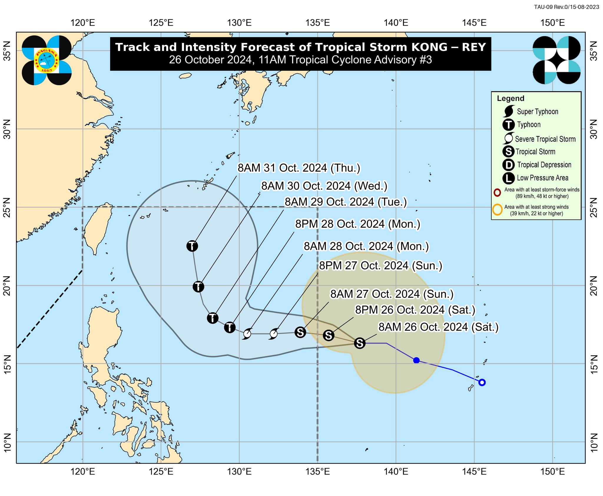
In its 11 a.m. bulletin, PAGASA stated that TS Kong-rey will be given the domestic name “Leon” once it enters the country’s area of responsibility.

PAGASA indicated that “Kong-rey” will move generally westward from Oct. 26 to 27 and will turn west-northwestward on Oct. 28, then north-northwestward for the rest of the forecast period.

“It is forecast to enter the Philippine Area of Responsibility (PAR) as a tropical storm tonight or early tomorrow morning (27 October),” PAGASA said.

PAGASA reported that TS Kong-rey maintains its strength while moving westward, with its center located 1,630 km east of Central Luzon. It has maximum sustained winds of 65 km/h near the center, gustiness of up to 80 km/h, and a central pressure of 996 hPa.

Within the PAR region, PAGASA noted that the path of Kong-rey “will remain far” from the Philippine landmass. “However, the track forecast may still shift within the limits of the forecast confidence cone, especially on days 4 and 5 of the track forecast,” it added.

PAGASA mentioned that “Kong-rey” is expected to gradually intensify and may reach the severe tropical storm category on Oct. 27. Furthermore, it may also reach typhoon status on Oct. 28.

“Depending on how close it gets during its recurvature over the Philippine Sea, the outer rainbands of KONG-REY may also affect Extreme Northern Luzon,” PAGASA said.

PAGASA also noted that TS Kong-rey may continue to influence the southwesterly wind flow initially triggered by Severe Tropical Storm Kristine, which may affect the western section of Southern Luzon, as well as the Visayas and Mindanao in the coming days.

“The approaching tropical cyclone may bring moderate to rough sea conditions over the northern and eastern seaboards of Luzon and the eastern seaboard of the Visayas,” PAGASA said.

Mariners are advised to “continue monitoring for updates and take precautionary measures as necessary.”

PAGASA urged the public and disaster risk reduction and management offices to continue monitoring updates related to TS Kong-rey.

RELATED STORY:

https://mb.com.ph/2024/10/26/trough-of-kristine

Related Tags

pagasa weather update Philippines weather PAGASA WEATHER UPDATE KristinePH Kong-rey
ADVERTISEMENT
.most-popular .layout-ratio{ padding-bottom: 79.13%; } @media (min-width: 768px) and (max-width: 1024px) { .widget-title { font-size: 15px !important; } }

{{ articles_filter_1561_widget.title }}

.most-popular .layout-ratio{ padding-bottom: 79.13%; } @media (min-width: 768px) and (max-width: 1024px) { .widget-title { font-size: 15px !important; } }

{{ articles_filter_1562_widget.title }}

.most-popular .layout-ratio{ padding-bottom: 79.13%; } @media (min-width: 768px) and (max-width: 1024px) { .widget-title { font-size: 15px !important; } }

{{ articles_filter_1563_widget.title }}

{{ articles_filter_1564_widget.title }}

.mb-article-details { position: relative; } .mb-article-details .article-body-preview, .mb-article-details .article-body-summary{ font-size: 17px; line-height: 30px; font-family: "Libre Caslon Text", serif; color: #000; } .mb-article-details .article-body-preview iframe , .mb-article-details .article-body-summary iframe{ width: 100%; margin: auto; } .read-more-background { background: linear-gradient(180deg, color(display-p3 1.000 1.000 1.000 / 0) 13.75%, color(display-p3 1.000 1.000 1.000 / 0.8) 30.79%, color(display-p3 1.000 1.000 1.000) 72.5%); position: absolute; height: 200px; width: 100%; bottom: 0; display: flex; justify-content: center; align-items: center; padding: 0; } .read-more-background a{ color: #000; } .read-more-btn { padding: 17px 45px; font-family: Inter; font-weight: 700; font-size: 18px; line-height: 16px; text-align: center; vertical-align: middle; border: 1px solid black; background-color: white; } .hidden { display: none; }
function initializeAllSwipers() { // Get all hidden inputs with cms_article_id document.querySelectorAll('[id^="cms_article_id_"]').forEach(function (input) { const cmsArticleId = input.value; const articleSelector = '#article-' + cmsArticleId + ' .body_images'; const swiperElement = document.querySelector(articleSelector); if (swiperElement && !swiperElement.classList.contains('swiper-initialized')) { new Swiper(articleSelector, { loop: true, pagination: false, navigation: { nextEl: '#article-' + cmsArticleId + ' .swiper-button-next', prevEl: '#article-' + cmsArticleId + ' .swiper-button-prev', }, }); } }); } setTimeout(initializeAllSwipers, 3000); const intersectionObserver = new IntersectionObserver( (entries) => { entries.forEach((entry) => { if (entry.isIntersecting) { const newUrl = entry.target.getAttribute("data-url"); if (newUrl) { history.pushState(null, null, newUrl); let article = entry.target; // Extract metadata const author = article.querySelector('.author-section').textContent.replace('By', '').trim(); const section = article.querySelector('.section-info ').textContent.replace(' ', ' '); const title = article.querySelector('.article-title h1').textContent; // Parse URL for Chartbeat path format const parsedUrl = new URL(newUrl, window.location.origin); const cleanUrl = parsedUrl.host + parsedUrl.pathname; // Update Chartbeat configuration if (typeof window._sf_async_config !== 'undefined') { window._sf_async_config.path = cleanUrl; window._sf_async_config.sections = section; window._sf_async_config.authors = author; } // Track virtual page view with Chartbeat if (typeof pSUPERFLY !== 'undefined' && typeof pSUPERFLY.virtualPage === 'function') { try { pSUPERFLY.virtualPage({ path: cleanUrl, title: title, sections: section, authors: author }); } catch (error) { console.error('ping error', error); } } // Optional: Update document title if (title && title !== document.title) { document.title = title; } } } }); }, { threshold: 0.1 } ); function showArticleBody(button) { const article = button.closest("article"); const summary = article.querySelector(".article-body-summary"); const body = article.querySelector(".article-body-preview"); const readMoreSection = article.querySelector(".read-more-background"); // Hide summary and read-more section summary.style.display = "none"; readMoreSection.style.display = "none"; // Show the full article body body.classList.remove("hidden"); } document.addEventListener("DOMContentLoaded", () => { let loadCount = 0; // Track how many times articles are loaded const offset = [1, 2, 3, 4, 5, 6, 7, 8, 9, 10]; // Offset values const currentUrl = window.location.pathname.substring(1); let isLoading = false; // Prevent multiple calls if (!currentUrl) { console.log("Current URL is invalid."); return; } const sentinel = document.getElementById("load-more-sentinel"); if (!sentinel) { console.log("Sentinel element not found."); return; } function isSentinelVisible() { const rect = sentinel.getBoundingClientRect(); return ( rect.top < window.innerHeight && rect.bottom >= 0 ); } function onScroll() { if (isLoading) return; if (isSentinelVisible()) { if (loadCount >= offset.length) { console.log("Maximum load attempts reached."); window.removeEventListener("scroll", onScroll); return; } isLoading = true; const currentOffset = offset[loadCount]; window.loadMoreItems().then(() => { let article = document.querySelector('#widget_1690 > div:nth-last-of-type(2) article'); intersectionObserver.observe(article) loadCount++; }).catch(error => { console.error("Error loading more items:", error); }).finally(() => { isLoading = false; }); } } window.addEventListener("scroll", onScroll); });

Sign up by email to receive news.