


 Philippines
National
'Kristine' maintains strength; 45 areas still under wind signals
Philippines
National
'Kristine' maintains strength; 45 areas still under wind signals
'Kristine' maintains strength; 45 areas still under wind signals
LPA near PAR develops into tropical depression


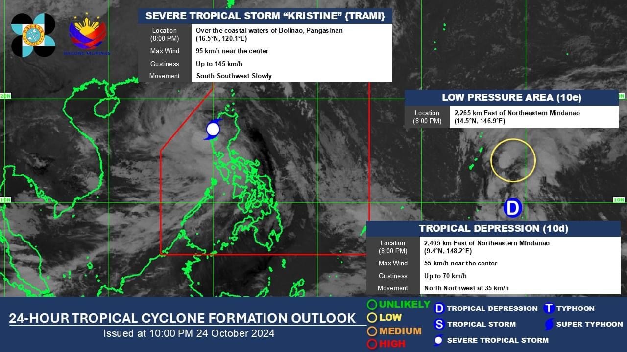
At least 45 areas, mostly in Luzon, remain under Signal Nos. 2 and 1 as Severe Tropical Storm “Kristine” (international name “Trami”) maintained its strength while slowly moving over Lingayen Gulf late Thursday evening, Oct. 24.
In its 11 p.m. bulletin, PAGASA said Signal No. 2 is still in effect in Metro Manila, Cagayan (including Babuyan Islands), Isabela, Quirino, Nueva Vizcaya, Apayao, Kalinga, Abra, Ifugao, Mountain Province, Benguet, Ilocos Norte, Ilocos Sur, La Union, Pangasinan, Aurora, Nueva Ecija, Tarlac, Zambales, Bataan, Pampanga, Bulacan, northern portion of Cavite (Ternate, Maragondon, Naic, Tanza, City of General Trias, Rosario, Cavite City, Noveleta, Kawit, Imus City, Bacoor City), northern portion of Rizal (Cainta, Taytay, Angono, San Mateo, Rodriguez, Tanay, City of Antipolo, Baras, Teresa, Morong), and northern portion of mainland Quezon (General Nakar).
Signal No. 1 is also still up in Batanes, the rest of Rizal, the rest of Cavite, Batangas, Laguna, the rest of Quezon, Occidental Mindoro, Oriental Mindoro (including Lubang Islands), Marinduque, Romblon, northern portion of mainland Palawan (El Nido, Taytay, Araceli, San Vicente, Dumaran, Roxas, including Calamian, Cuyo, and Kalayaan Islands), Camarines Norte, Camarines Sur, Catanduanes, Albay, Sorsogon, Masbate (including Ticao and Burias Islands), Aklan, Capiz, Antique (including Caluya Islands), Iloilo, Bantayan Islands, western portion of Northern Samar (Lope de Vega, Rosario, Biri, San Isidro, Capul, San Vicente, Victoria, Lavezares, San Antonio, Mondragon, San Jose, Catarman, San Roque, Allen, Bobon), and northern portion of Samar (Calbayog City, Tagapul-An).
Rains may also continue to affect parts of the country over the next 24 hours.
READ MORE: https://mb.com.ph/2024/10/24/kristine-slowly-moves-toward-lingayen-gulf
PAGASA said the severe tropical storm has maximum sustained winds of 95 kilometers per hour (kph) near the center and gusts reaching up to 145 kph.
As of 10 p.m., Kristine was moving slowly south-southwestward over the coastal waters of Bolinao, Pangasinan.
It is expected to exit the Philippine Area of Responsibility (PAR) by Friday afternoon, Oct. 25.
However, PAGASA said there is a possibility that Kristine may follow a looping path over the West Philippine Sea by Sunday or Monday, Oct. 27 or 28, which could result in its return to the PAR.
The scenario depends on the movement of a weather disturbance monitored 2,405 kilometers east of northeastern Mindanao.
This weather disturbance, initially spotted as a low-pressure area (LPA), developed into a tropical depression at 8 p.m. on Thursday. If it enters the PAR, it will be given the local name “Leon.”
Meanwhile, another LPA was monitored 2,265 kilometers east of northeastern Mindanao but has a low chance of developing into a tropical depression within the next 24 hours.