


 Philippines
National
Tropical storm 'Kristine' slightly intensifies over Philippine Sea
Philippines
National
Tropical storm 'Kristine' slightly intensifies over Philippine Sea
Tropical storm 'Kristine' slightly intensifies over Philippine Sea


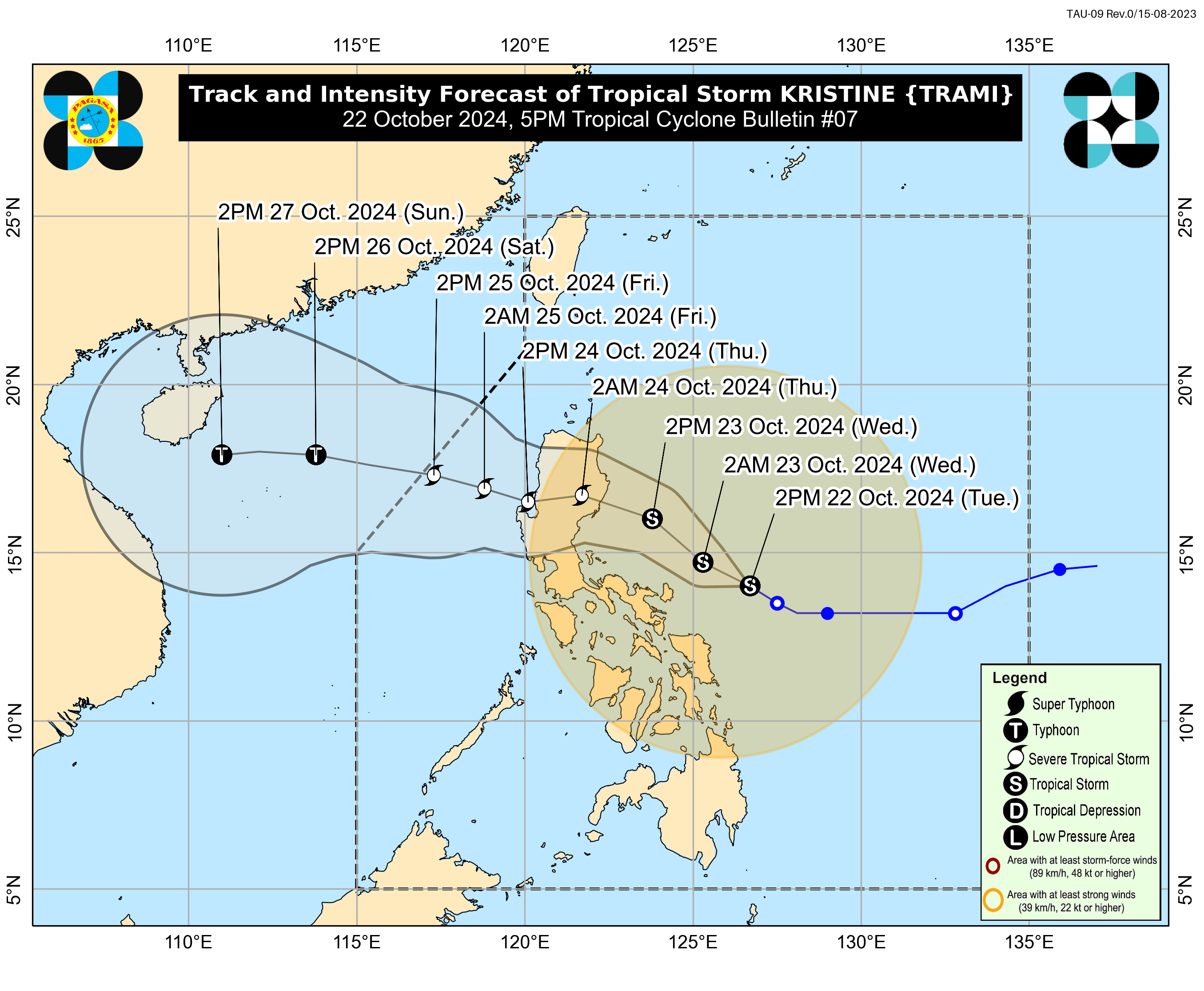
Tropical Storm “Kristine” (international name “Trami”) slightly strengthened as it moves across the Philippine Sea, east of Bicol Region, said the Philippine Atmospheric, Geophysical and Astronomical Services Administration (PAGASA) on Tuesday afternoon, Oct. 22.
As of 5 p.m., Kristine has maximum sustained winds of 75 kilometers per hour (kph) near the center and gusts reaching up to 90 kph.
The storm’s center was located 390 kilometers east of Daet, Camarines Norte, and it is expected to move west-northwestward at 15 kph.
PAGASA said Kristine could make landfall in Isabela or northern Aurora on Wednesday evening, Oct. 23, or Thursday morning, Oct. 24, potentially as a severe tropical storm.
Wind warnings
In anticipation of the storm, PAGASA has issued Wind Signal No. 2 over Catanduanes, eastern portion of Camarines Norte, eastern portion of Camarines Sur, eastern portion of Albay, and eastern portion of Sorsogon.
Signal No. 1 remains in effect over Metro Manila, Ilocos Norte, Ilocos Sur, La Union, Pangasinan, Apayao, Kalinga, Abra, Mountain Province, Ifugao, Benguet, Cagayan (including Babuyan Islands), Isabela, Quirino, Nueva Vizcaya, Aurora, Nueva Ecija, Tarlac, Zambales, Bataan, Pampanga, Bulacan, Cavite, Laguna, Batangas, Rizal, Quezon (including Pollilo Islands), Occidental Mindoro (including Lubang Islands), Oriental Mindoro, Masbate (including Ticao and Burias Islands), Marinduque, Romblon, the rest of Camarines Norte, the rest of Camarines Sur, the rest of Albay, the rest of Sorsogon, the rest of Eastern Samar, the rest of Northern Samar, Samar, Leyte, Biliran, Southern Leyte, Dinagat Islands, and Surigao del Norte (including Siargao-Bucas Grande Group).
PAGASA said the highest wind signal that may be raised during the passage of the storm is Signal No. 3
Rainfall forecast
PAGASA warned of heavy to intense rainfall in Bicol Region, Isabela, Aurora, and Quezon over the next 24 hours.
Moderate to, at times, intense are also expected in Metro Manila, the rest of Luzon, Eastern Visayas, Dinagat Islands, and Surigao del Norte.
The trough or extension of Kristine may also bring moderate to heavy rains to Zamboanga Peninsula, Northern Mindanao, Bangsamoro Autonomous Region in Muslim Mindanao, Soccsksargen, and the rest of Visayas.
The rest of Mindanao is likely to experience isolated rain showers or thunderstorms.
Storm surge warnings
PAGASA also issued storm surge warnings due to the anticipated abnormal rise in sea levels caused by the approaching storm.
Areas at risk include the eastern coasts of Albay, Aurora, Cagayan, Camarines Sur, Catanduanes, and Isabela.
READ MORE: https://mb.com.ph/2024/10/22/signal-no-2-raised-in-catanduanes
Kristine may exit the Philippine Area of Responsibility on Friday, Oct. 25.