


 Philippines
National
Signal No. 2 raised in Catanduanes; Metro Manila now under Signal No. 1
Philippines
National
Signal No. 2 raised in Catanduanes; Metro Manila now under Signal No. 1
Signal No. 2 raised in Catanduanes; Metro Manila now under Signal No. 1


At A Glance
- PAGASA said the highest tropical cyclone wind signal that may be raised during the passage of Kristine is Signal No. 3.
- Kristine could make landfall over Isabela or northern Aurora on Wednesday evening, Oct. 23, or Thursday morning, Oct. 24, as a severe tropical storm.
- It may exit the Philippine Area of Responsibility on Friday, Oct. 25.
Tropical cyclone wind Signal No. 2 was raised in Catanduanes, while more areas, including Metro Manila, are now under Signal No. 1 due to the approaching Tropical Storm “Kristine” (international name “Trami”), said the Philippine Atmospheric, Geophysical and Astronomical Services Administration (PAGASA) on Tuesday, Oct. 22.
In the PAGASA’s 11 a.m. bulletin, Signal No. 1 was in effect over Metro Manila, Ilocos Norte, Ilocos Sur, La Union, Pangasinan, Apayao, Kalinga, Abra, Mountain Province, Ifugao, Benguet, Cagayan (including Babuyan Islands), Isabela, Quirino, Nueva Vizcaya, Aurora, Nueva Ecija, Tarlac, Zambales, Bataan, Pampanga, Bulacan, Cavite, Laguna, Batangas, Rizal, Quezon (including Pollilo Islands), Masbate (including Ticao Island and Burias Island), Marinduque, Romblon, Camarines Norte, Camarines Sur, Albay, Sorsogon, Eastern Samar, Northern Samar, Samar, Leyte, Biliran, Southern Leyte, Dinagat Islands, and Surigao del Norte (including Siargao-Bucas Grande Group).
PAGASA said the highest tropical cyclone wind signal that may be raised during the passage of Kristine is Signal No. 3.
Several areas across the country may also experience rains due to Kristine’s vast circulation.
READ MORE: https://mb.com.ph/2024/10/22/kristine-intensifies-into-tropical-storm
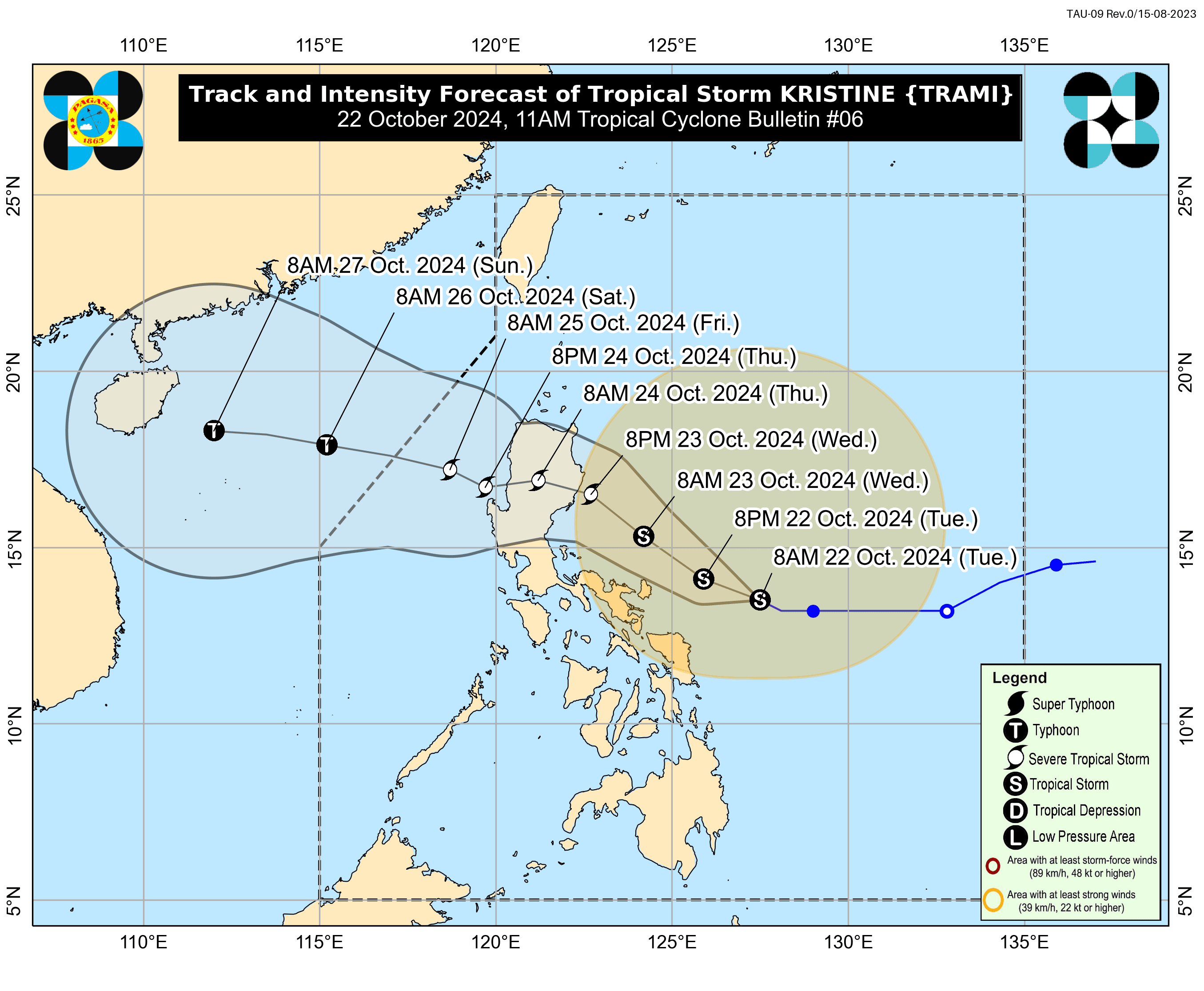
Forecast track
As of 10 a.m., the center of tropical storm Kristine was located 335 kilometers east of Virac, Catanduanes.
The storm has maximum sustained winds of 65 kilometers per hour (kph) near the center and gusts reaching up to 80 kph. It is expected to move west-northwestward at 10 kph.
PAGASA said Kristine could make landfall over Isabela or northern Aurora on Wednesday evening, Oct. 23, or Thursday morning, Oct. 24, as a severe tropical storm.
It pointed out that there could still be changes in the track forecast, depending on the movement of the surrounding weather systems in the next few days.
Over the West Philippine Sea, Kristine may reach typhoon category before exiting the Philippine Area of Responsibility on Friday, Oct. 25.
Storm surge
As tropical storm Kristine approaches the country, residents along the eastern seaboards of Luzon and parts of the Visayas are on high alert for potential storm surges.
The 24-hour sea condition outlook indicates high seas up to 7 meters over the coastal waters of Batanes, Cagayan (including Babuyan Islands), Isabela, Catanduanes, Camarines Norte, and the northern and eastern seaboards of Camarines Sur.
In addition, high seas up to 6 meters are expected along the coastal waters of northern Aurora, Polillo Islands, and Ilocos Norte.
As sea travel is considered risky for all vessels, mariners are advised to remain in port or seek shelter or safe harbor immediately until conditions improve.
Very rough seas up to 5 meters are also anticipated along the remaining seaboards of Ilocos Region, the eastern seaboard of Albay, eastern seaboard of Sorsogon, and northern and eastern seaboards of Northern Samar.
Rough seas up to 4 meters are expected in Zambales and the eastern seaboard of Eastern Samar, while conditions of up to 3.5 meters will affect Cagayancillo Island, the eastern coast of Quezon, Dinagat Island, seaboard of Southern Leyte, northern and western seaboards of Surigao del Norte, eastern and southern seaboards of Bohol, Agusan del Norte, and Camiguin.
Seas up to 3 meters may also affect the remaining seaboards of Bicol Region, Quezon, Zamboanga del Norte, Romblon, the remaining seaboards of Visayas, western seaboard of Bataan, western seaboard of Occidental Mindoro, and northernand western seaboards of Calamian Island.
Mariners of small seacrafts, including all motor bancas, are strongly advised not to venture out to sea under these conditions, especially if they are inexperienced or operating ill-equipped vessels.