


 Philippines
National
PAGASA lifts Signal No. 3; 'Goring' expected to leave PAR on Aug. 31
Philippines
National
PAGASA lifts Signal No. 3; 'Goring' expected to leave PAR on Aug. 31
PAGASA lifts Signal No. 3; 'Goring' expected to leave PAR on Aug. 31
By Sonny Daanoy


At A Glance
- The state weather bureau lowered the wind signal for the eastern portion of Isabela to TCWS No. 2, marking the last area under Signal No. 3.
- At 11 p.m. PAGASA's update, 'Goring' has maximum sustained winds of 185 kilometers per hour (kph) near the center and gustiness of up to 230 kph.
- The super typhoon was spotted 125 km east of Casiguran, Aurora, while moving at 10 kph.
- PAGASA also forecasts that STY Goring will exit the Philippine Area of Responsibility (PAR) between the afternoon or evening of Thursday, Aug. 31.
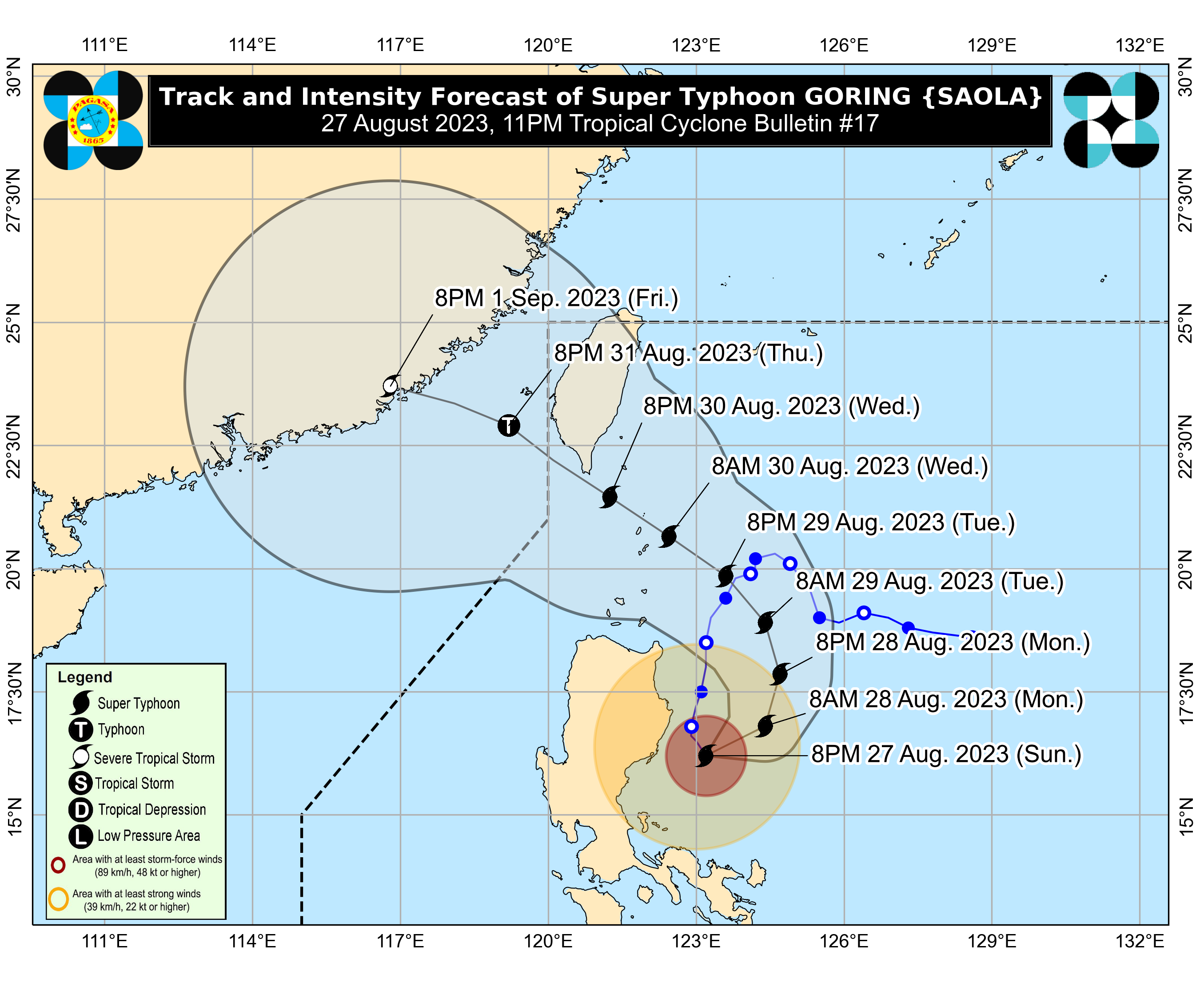
The Philippine Atmospheric, Geophysical and Astronomical Services Administration (PAGASA) on Sunday, Aug. 27, lifted Tropical Cyclone Wind Signal (TCWS) No. 3 as Super Typhoon Goring (international name: Saola) began its counter-clockwise loop over the Philippine Sea.
In its latest update, the state weather bureau said the eastern portion of Isabela (Dinapigue, San Mariano, Naguilian, San Guillermo, Luna, City of Cauayan, Echague, Ilagan City, Angadanan, Benito Soliven, Tumauini, Reina Mercedes, San Agustin, Palanan, Divilacan, Gamu, Jones, Maconacon) are currently under Signal No. 2 along with the eastern portion of Quirino (Maddela), and the extreme northern portion of Aurora (Casiguran, Dinalungan, Dilasag).
Meanwhile, Batanes, Babuyan Islands, mainland Cagayan, the rest of Isabela, the rest of Quirino, Nueva Vizcaya, Apayao, Kalinga, Abra, Mountain Province, Ifugao, the eastern portion of Benguet (Bokod, Buguias, Kabayan, Mankayan), the eastern portion of Ilocos Norte (Pagudpud, Adams, Vintar, Carasi, Nueva Era, Banna, Marcos, Dingras, Solsona, Piddig, Dumalneg, Bangui), the eastern portion of Nueva Ecija (Carranglan, Pantabangan, Bongabon, Gabaldon, Laur, Rizal), the rest of Aurora, Polillo Islands, and Calaguas Islands are under Signal No. 1.
READ:
Moves in 'counter-clockwise' loop
PAGASA stated that “Goring” has begun its anticipated trajectory and is currently following a counter-clockwise loop path over the Philippine Sea until Aug. 28, after which it is expected to generally turn northwestward on Aug. 29
READ:
https://mb.com.ph/2023/8/27/goring-maintains-strength-begins-loop-over-ph-sea-1
PAGASA said "Goring" is maintaining maximum sustained winds of 185 kilometers per hour (kph) near the center and gustiness of up to 230 kph.
The super typhoon was also spotted 125 km east of Casiguran, Aurora, while moving at 10 kph.
Landfall possibility not ruled out
"On the track forecast, the super typhoon will make close approach (landfall scenario not ruled out) to Batanes between Wednesday morning and evening and to the southern portion of Taiwan between Wednesday evening and Thursday morning," PAGASA said.
Based on its forecast, PAGASA said “Goring” will exit the Philippine Area of Responsibility (PAR) sometime during the afternoon or evening of Thursday, Aug. 31.