






Manila Bulletin
 Philippines
National
'Obet' to exit PAR within 12 hours; may enhance 'habagat' in coming days
Philippines
National
'Obet' to exit PAR within 12 hours; may enhance 'habagat' in coming days
Philippines
National
'Obet' to exit PAR within 12 hours; may enhance 'habagat' in coming days
'Obet' to exit PAR within 12 hours; may enhance 'habagat' in coming days
Published Aug 24, 2026 06:12 pm


At A Glance
- PAGASA weather specialist Grace Castañeda said Obet has no direct effect on the country, but it may enhance the habagat as it moves generally northwestward in the coming days.
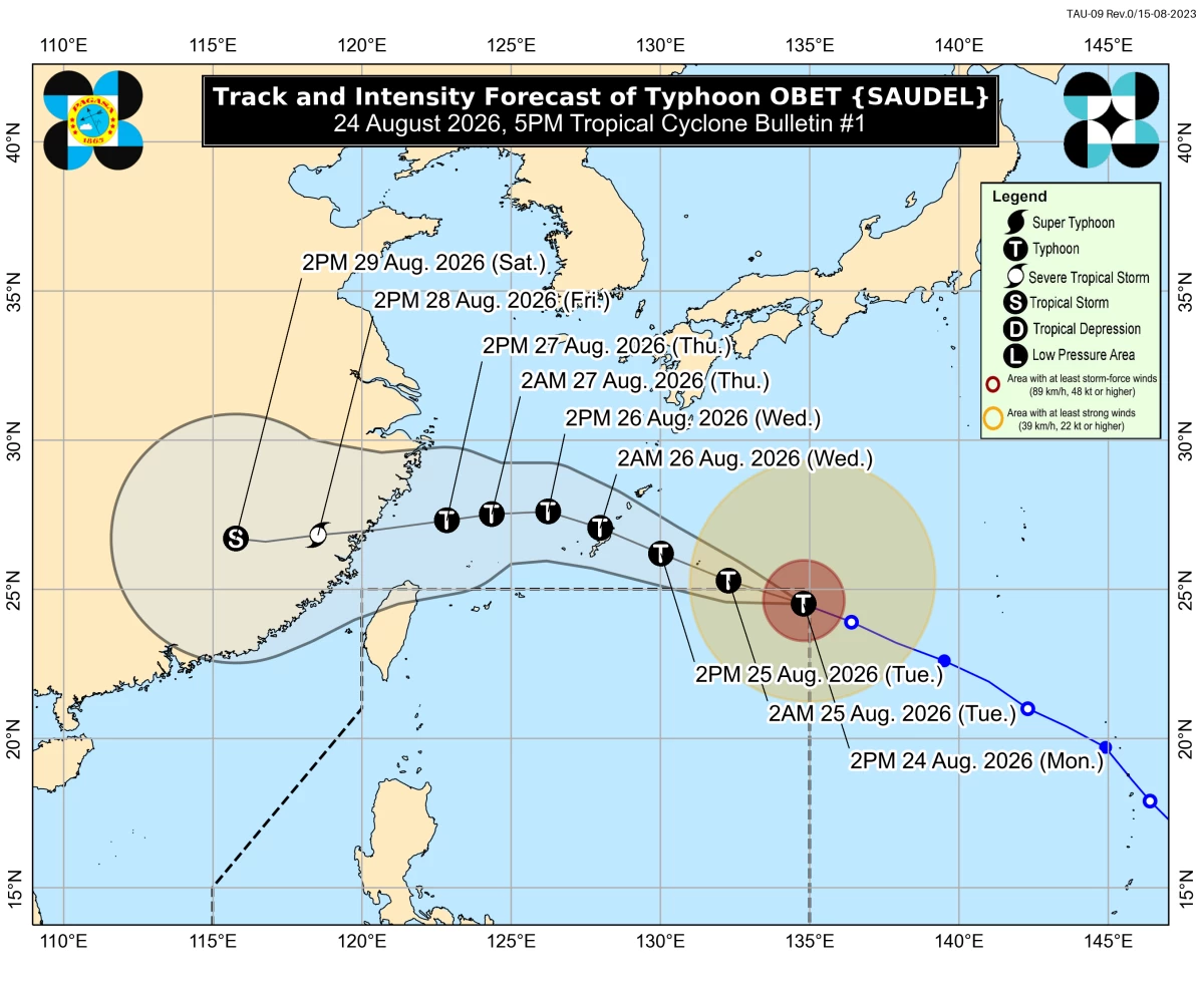
PAGASA
Typhoon Obet (international name “Saudel”) is expected to exit the Philippine Area of Responsibility (PAR) within the next 12 hours, but it may enhance the southwest monsoon or “habagat” in the coming days, the Philippine Atmospheric, Geophysical and Astronomical Services Administration (PAGASA) said on Monday, Aug. 24.
Obet entered the PAR at 1:40 p.m. Monday.
As of 5 p.m., Obet was located 1,350 kilometers east-northeast of extreme Northern Luzon, packing maximum sustained winds of 165 kilometers per hour (kph) near the center and gustiness of up to 205 kph.
The typhoon is expected to slightly intensify but may no longer reach super typhoon strength.
PAGASA weather specialist Grace Castañeda said Obet has no direct effect on the country, but it may enhance the habagat as it moves generally northwestward in the coming days.
“So yung habagat ang ineexpect natin na magdudulot ng mga pag-ulan sa malaking bahagi muli ng Luzon sa mga susunod na araw (So it is the habagat that we expect to bring rains again to a large part of Luzon in the coming days),” Castañeda said.
The habagat is currently affecting parts of Luzon, although it is not as strong compared with previous days.
“Sa ngayon habagat pa rin ang nakakaapekto sa malaking bahagi ng Luzon pero hindi po siya ganoon kalakas compared noong mga nakaraang araw pero may mararanasan pa rin tayo ng maulap na kalangitan at scattered na mga pag-ulan sa Metro Manila maging sa bahagi rin ng Ilocos Region, Cordillera Administrative Region, Cagayan Valley, Central Luzon, Cavite, Batangas, at Rizal (For now, the habagat is still affecting a large part of Luzon, but it is not as strong compared with previous days. However, we will still experience cloudy skies and scattered rains in Metro Manila, as well as parts of the Ilocos Region, Cordillera Administrative Region, Cagayan Valley, Central Luzon, Cavite, Batangas, and Rizal),” she said.
Castañeda advised the public that thunderstorms are possible, particularly in the afternoon and evening.
Meanwhile, PAGASA is also monitoring two weather systems outside the PAR.
Tropical Depression Gaenari, formerly known as “Neneng,” was located 505 kilometers north-northwest of Itbayat, Batanes.
Castañeda said it is not expected to enter the PAR or directly affect the country, but it continues to influence the habagat and help steer the monsoon, contributing to rains particularly over the western sections of Northern and Central Luzon.
Tropical Storm Atsani was located 1,765 kilometers east of Central Luzon and is moving away from the PAR.
Castañeda said there are two possible scenarios for Atsani.
If it moves closer to Obet, it could weaken and become a trough or extension of Obet.
If the distance between the two systems remains greater, Atsani could follow a similar track as Obet and possibly enter the PAR around Wednesday, Aug. 26.
However, she said Atsani is not expected to directly affect any part of the country.