






Manila Bulletin
 Philippines
National
Another rainy week over parts of the Philippines as Typhoon Saudel set to enter PAR
Philippines
National
Another rainy week over parts of the Philippines as Typhoon Saudel set to enter PAR
Philippines
National
Another rainy week over parts of the Philippines as Typhoon Saudel set to enter PAR
Another rainy week over parts of the Philippines as Typhoon Saudel set to enter PAR
Published Aug 23, 2026 09:43 am


At A Glance
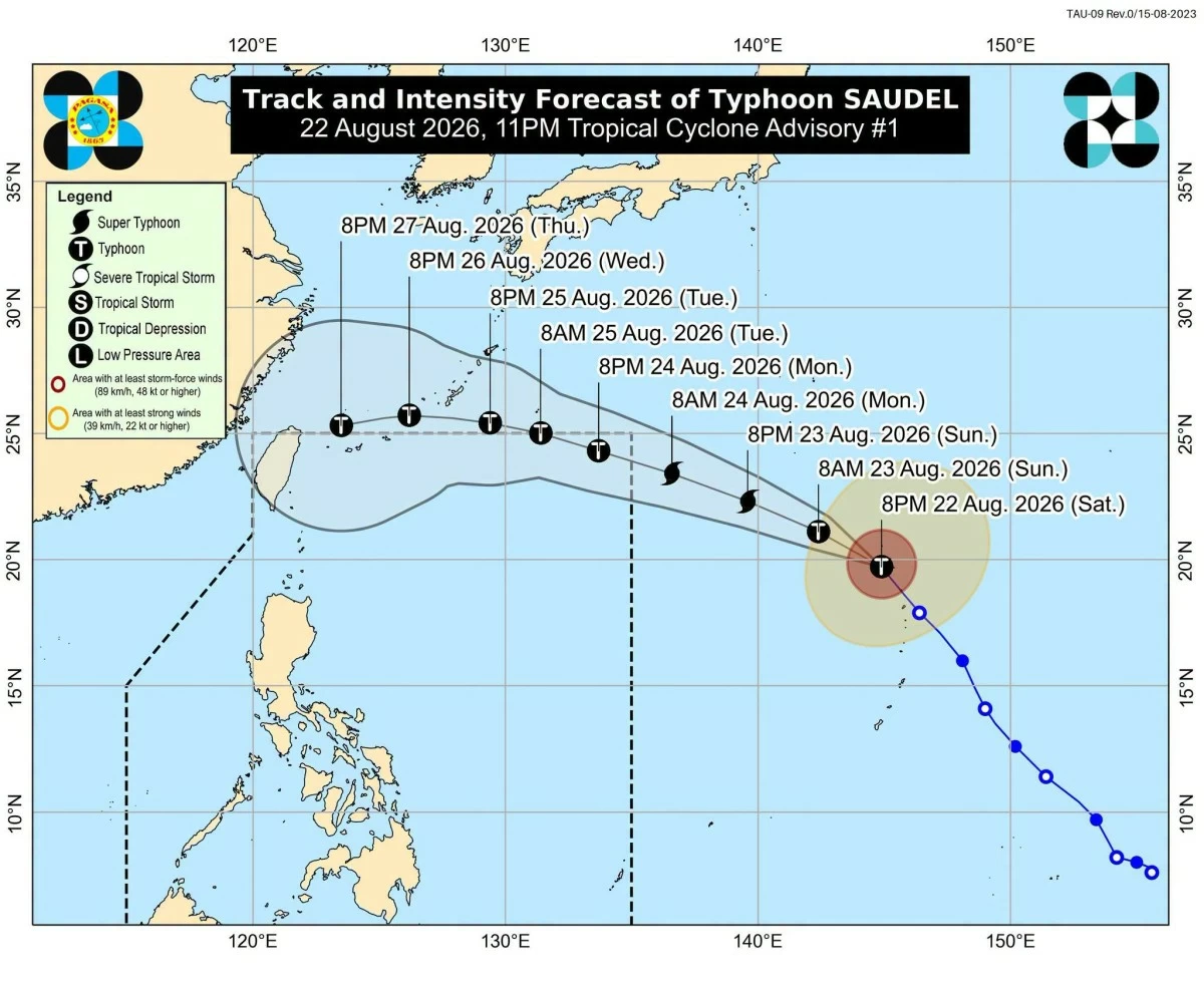
- Typhoon Saudel was located 2,245 kilometers east of extreme Northern Luzon as of Sunday, and is expected to briefly enter the northeastern boundary of PAR on Monday, Aug. 24.
- Once inside PAR, PAGASA will assign it the local name "Obet."
- The typhoon-enhanced habagat is expected to bring occasional heavy rains, particularly over western Luzon and Visayas by midweek.
PAGASA
The Philippines could face another round of heavy monsoon rains this week as the typhoon with the international name “Saudel” is expected to enter the Philippine Area of Responsibility (PAR) and enhance the southwest monsoon or “habagat.”
Philippine Atmospheric, Geophysical and Astronomical Services Administration (PAGASA) weather specialist Obet Badrina on Sunday, Aug. 23, said Saudel is likely to enter PAR on Monday, Aug. 24, but is unlikely to make landfall in the country.
Saudel was located 2,245 kilometers east of extreme Northern Luzon as of Sunday, and is expected to briefly enter the northeastern boundary of PAR.
Once inside PAR, PAGASA will assign it the local name “Obet.”
“Bagamat nga itong Saudel, base po sa track niya, medyo maliit naman yung posibilidad or almost less likely po na ito ay tumama sa kalupaan ng ating bansa, inaasahan natin na palalakasin nito yung habagat bandang araw nga po ng Martes hanggang Miyerkules (Although Saudel has a low, or almost unlikely, chance of making landfall in the country based on its track, we expect it to strengthen the habagat around Tuesday to Wednesday, Aug. 25 to 26),” Badrina said.
The enhanced habagat is expected to bring occasional heavy rains, particularly over western Luzon and Visayas.
“Once na pumasok ito ng Philippine Area of Responsibility, bandang midweek po, asahan ng mga kababayan natin na magkakaroon na ulit tayo ng mga occasional heavy rains (Once it enters the Philippine Area of Responsibility around midweek, our countrymen should expect occasional heavy rains again),” Badrina said.
PAGASA is also monitoring two other tropical cyclones outside PAR.
The tropical cyclone formerly known as “Neneng” has strengthened again after weakening into a low-pressure area, but Badrina said it has little chance of re-entering PAR.
Another tropical cyclone located 1,205 kilometers east of Eastern Visayas is expected to move northeastward and may not enter PAR.
“Itong bagyo naman sa may silangan ng Visayas ay posibleng sumunod siya sa bagyong Saudel. So nagkakaroon po sila ngayon ng interaction (This cyclone east of the Visayas could possibly follow Saudel, so the two systems are currently interacting),” he said.
As early as Sunday, Badrina said the habagat is already bringing heavy rains to Batanes and cloudy skies with scattered rains over Metro Manila, Ilocos Region, Cordillera Administrative Region, Central Luzon, Rizal, Cavite, Batangas, Occidental Mindoro, and the rest of Cagayan Valley
Meanwhile, generally fair weather is expected over Bicol Region, Visayas, and Mindanao, although localized rain showers and thunderstorms remain possible.