






Manila Bulletin
 Philippines
National
Intense rains to persist as tropical cyclones enhance 'habagat' — PAGASA
Philippines
National
Intense rains to persist as tropical cyclones enhance 'habagat' — PAGASA
Philippines
National
Intense rains to persist as tropical cyclones enhance 'habagat' — PAGASA
Intense rains to persist as tropical cyclones enhance 'habagat' — PAGASA
Published Aug 9, 2026 09:19 am


At A Glance
- PAGASA weather specialist Aldczar Aurelio said rainy weather is expected to continue over Luzon, Western Visayas, Negros Island Region, and Central Visayas due to the habagat.
- He advised the public to remain alert for possible flash floods and landslides, especially in areas that have experienced continuous rainfall over the past few days, as the already saturated soil increases the risk of flooding and landslides.
PAGASA
Intense rains will continue to batter parts of Luzon and the Visayas through Tuesday, Aug. 11, as two tropical cyclones outside the Philippine Area of Responsibility (PAR) enhance the southwest monsoon or “habagat,” the Philippine Atmospheric, Geophysical and Astronomical Services Administration (PAGASA) said Sunday, Aug. 9.
PAGASA weather specialist Aldczar Aurelio said rainy weather is expected to continue over Luzon, Western Visayas, Negros Island Region, and Central Visayas due to the habagat.
The rest of the Visayas and the entire Mindanao will generally have fair weather, although partly cloudy to cloudy skies with isolated rain showers or thunderstorms may still occur.
For Sunday, more than 200 millimeters of rainfall, classified as intense to torrential, is expected in Ilocos Sur and Benguet.
Rainfall of 100 to 200 millimeters, or heavy to intense, is forecast over La Union, Abra, Zambales, Bataan, Metro Manila, Rizal, Cavite, Batangas, and Occidental Mindoro.
Meanwhile, 50 to 100 millimeters of moderate to heavy rain is expected in Ilocos Norte, Pangasinan, Apayao, Kalinga, Mountain Province, Ifugao, Nueva Vizcaya, Tarlac, Nueva Ecija, Pampanga, Bulacan, Laguna, Oriental Mindoro, and Antique.
The rains are expected to continue into Monday, Aug. 10.
Rainfall of 100 to 200 millimeters is forecast over Ilocos Sur, La Union, Benguet, Zambales, Bataan, and Occidental Mindoro, while 50 to 100 millimeters is expected over Ilocos Norte, Pangasinan, Abra, Kalinga, Mountain Province, Ifugao, Nueva Vizcaya, Tarlac, Nueva Ecija, Pampanga, Bulacan, Metro Manila, Rizal, Cavite, Batangas, Oriental Mindoro, and Antique.
On Tuesday, Aug. 11, Zambales, Bataan, and Occidental Mindoro may receive 100 to 200 millimeters of rain.
La Union, Ilocos Sur, Pangasinan, Abra, Benguet, Tarlac, Pampanga, Nueva Ecija, Cavite, Batangas, and Antique may receive 50 to 100 millimeters of rainfall.
Aurelio advised the public to remain alert for possible flash floods and landslides, especially in areas that have experienced continuous rainfall over the past few days, as the already saturated soil increases the risk of flooding and landslides.
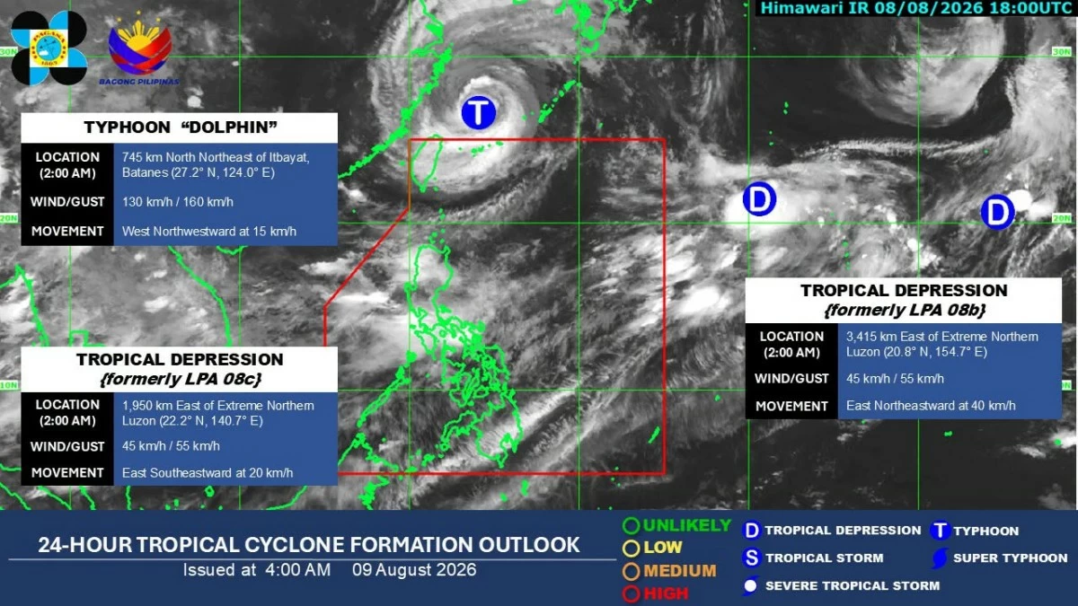
Meanwhile, PAGASA is monitoring three tropical cyclones outside the PAR.
Typhoon Dolphin was located 745 kilometers north-northeast of Itbayat, Batanes.
“Malabo na itong pumasok sa ating Philippine Area of Responsibility dahil ito'y kikilos pa-kanluran o papunta sa southern part ng China (It is unlikely to enter our Philippine Area of Responsibility because it will move westward toward the southern part of China),” Aurelio said.
A tropical depression east of extreme Northern Luzon was located more than 1,980 kilometers east of the area, with maximum sustained winds of 45 kilometers per hour.
Aurelio said it is also unlikely to enter the PAR.
“Base sa ating mga data at analysis, mababa ang tsansa na pumasok sa ating area of responsibility dahil ito'y kikilos pa-silangan o palayo sa ating bansa (Based on our data and analysis, there is a low chance that it will enter our area of responsibility because it will move eastward, away from the country),” he said.
The third tropical depression was located 3,435 kilometers east of extreme Northern Luzon, also with maximum sustained winds of 45 kilometers per hour.
Aurelio said this has a low chance of entering the PAR as it is expected to move away from the Philippines.