ADVERTISEMENT

'Maymay' now over Philippine Sea, may weaken into an LPA

Published Aug 6, 2026 05:40 pm
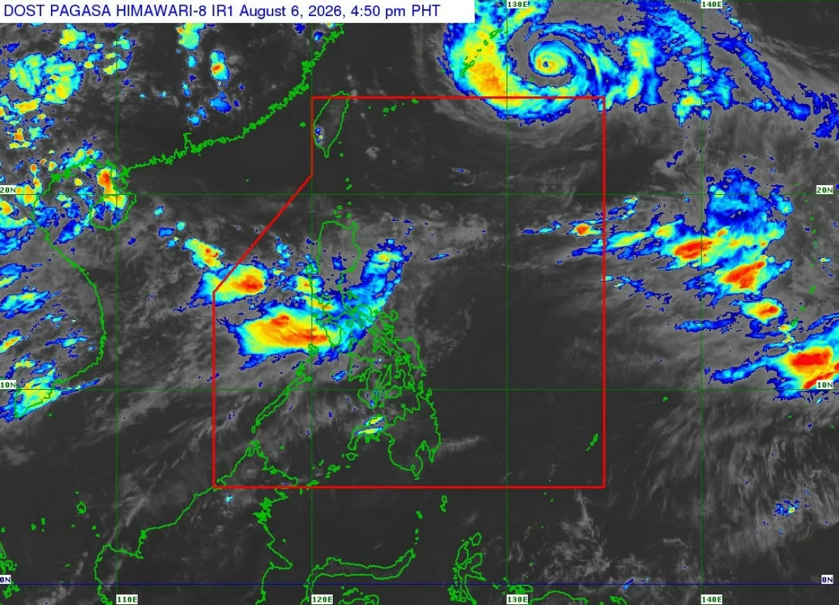
Satellite image showing Tropical Depression Maymay (Kujira) and Typhoon Dolphin (Courtesy of PAGASA)
Tropical Depression Maymay (international name “Kujira”) weakened further after moving over the Philippine Sea on Thursday afternoon, Aug. 6, said the Philippine Atmospheric, Geophysical and Astronomical Services Administration (PAGASA).
As of 4 p.m., the center of Maymay was estimated at 150 kilometers east northeast of Echague, Isabela.
It had maximum sustained winds of 45 kilometers per hour (kph) near the center and gustiness of up to 70 kph.
It was moving east-southeastward at 35 kph.
Based on the 5 p.m. bulletin, Tropical Cyclone Wind Signal No. 1 remained in effect over the southeastern portion of mainland Cagayan (Tuao, Piat, Enrile, Alcala, Amulung, Baggao, Solana, Tuguegarao City, Gattaran, Peñablanca, Iguig), Isabela, Quirino, the northeastern portion of Nueva Vizcaya (Dupax del Norte, Kasibu, Quezon, Bagabag, Diadi, Bayombong, Ambaguio, Villaverde, Bambang, Solano, Alfonso Castañeda, Dupax del Sur), the northern and central portions of Aurora (Dilasag, Casiguran, Dinalungan, Dipaculao), the eastern portion of Kalinga (City of Tabuk, Pinukpuk, Tanudan, Lubuagan, Rizal), the eastern portion of Mountain Province (Paracelis, Natonin, Barlig), and the eastern portion of Ifugao (Lagawe, Aguinaldo, Asipulo, Hingyon, Kiangan, Lamut, Alfonso Lista, Mayoyao, Banaue).
PAGASA said the wind signal would be lifted once the tropical depression weakens into an LPA.
Based on the latest forecast, Maymay is expected to continue weakening and may become a remnant low by Thursday evening or early Friday, Aug. 7.
Afterward, the remnant low will move generally southeastward before merging with the larger circulation of a typhoon with the international name "Dolphin."
As of 3 p.m., the center of the typhoon was located 1,255 kilometers east-northeast of extreme Northern Luzon, packing maximum sustained winds of 150 kph near the center and gustiness of up to 185 kph.
It was moving west-northwestward at 20 kph and was passing near the northern boundary of the Philippine Area of Responsibility (PAR).
PAGASA said Typhoon Dolphin still has only a slim chance of entering the PAR as it moves toward the southern island of Japan and later China.
However, it may enhance the southwest monsoon (habagat) by drawing warm and moist air toward Luzon.
The typhoon-enhanced habagat is expected to be the dominant weather system through the weekend, bringing more rains, particularly over the western sections of Luzon and Visayas.

Related Tags

PAGASA TROPICAL DEPRESSION MAYMAY TYPHOON DOLPHIN HABAGAT SOUTHWEST MONSOON
ADVERTISEMENT
.most-popular .layout-ratio{ padding-bottom: 79.13%; } @media (min-width: 768px) and (max-width: 1024px) { .widget-title { font-size: 15px !important; } }

{{ articles_filter_1561_widget.title }}

.most-popular .layout-ratio{ padding-bottom: 79.13%; } @media (min-width: 768px) and (max-width: 1024px) { .widget-title { font-size: 15px !important; } }

{{ static_articles_1562_widget.title }}

.most-popular .layout-ratio{ padding-bottom: 79.13%; } @media (min-width: 768px) and (max-width: 1024px) { .widget-title { font-size: 15px !important; } }

{{ articles_filter_1563_widget.title }}

{{ articles_filter_1564_widget.title }}

.mb-article-details { position: relative; } .mb-article-details .article-body-preview, .mb-article-details .article-body-summary{ font-size: 17px; line-height: 30px; font-family: "Libre Caslon Text", serif; color: #000; } .mb-article-details .article-body-preview iframe , .mb-article-details .article-body-summary iframe{ width: 100%; margin: auto; } .read-more-background { background: linear-gradient(180deg, color(display-p3 1.000 1.000 1.000 / 0) 13.75%, color(display-p3 1.000 1.000 1.000 / 0.8) 30.79%, color(display-p3 1.000 1.000 1.000) 72.5%); position: absolute; height: 200px; width: 100%; bottom: 0; display: flex; justify-content: center; align-items: center; padding: 0; } .read-more-background a{ color: #000; } .read-more-btn { padding: 17px 45px; font-family: Inter; font-weight: 700; font-size: 18px; line-height: 16px; text-align: center; vertical-align: middle; border: 1px solid black; background-color: white; } .hidden { display: none; }
function initializeAllSwipers() { // Get all hidden inputs with cms_article_id document.querySelectorAll('[id^="cms_article_id_"]').forEach(function (input) { const cmsArticleId = input.value; const articleSelector = '#article-' + cmsArticleId + ' .body_images'; const swiperElement = document.querySelector(articleSelector); if (swiperElement && !swiperElement.classList.contains('swiper-initialized')) { new Swiper(articleSelector, { loop: true, pagination: false, navigation: { nextEl: '#article-' + cmsArticleId + ' .swiper-button-next', prevEl: '#article-' + cmsArticleId + ' .swiper-button-prev', }, }); } }); } setTimeout(initializeAllSwipers, 3000); const intersectionObserver = new IntersectionObserver( (entries) => { entries.forEach((entry) => { if (entry.isIntersecting) { const newUrl = entry.target.getAttribute("data-url"); if (newUrl) { history.pushState(null, null, newUrl); let article = entry.target; // Extract metadata const author = article.querySelector('.author-section').textContent.replace('By', '').trim(); const section = article.querySelector('.section-info ').textContent.replace(' ', ' '); const title = article.querySelector('.article-title h1').textContent; // Parse URL for Chartbeat path format const parsedUrl = new URL(newUrl, window.location.origin); const cleanUrl = parsedUrl.host + parsedUrl.pathname; // Update Chartbeat configuration if (typeof window._sf_async_config !== 'undefined') { window._sf_async_config.path = cleanUrl; window._sf_async_config.sections = section; window._sf_async_config.authors = author; } // Track virtual page view with Chartbeat if (typeof pSUPERFLY !== 'undefined' && typeof pSUPERFLY.virtualPage === 'function') { try { pSUPERFLY.virtualPage({ path: cleanUrl, title: title, sections: section, authors: author }); } catch (error) { console.error('ping error', error); } } // Optional: Update document title if (title && title !== document.title) { document.title = title; } } } }); }, { threshold: 0.1 } ); function showArticleBody(button) { const article = button.closest("article"); const summary = article.querySelector(".article-body-summary"); const body = article.querySelector(".article-body-preview"); const readMoreSection = article.querySelector(".read-more-background"); // Hide summary and read-more section summary.style.display = "none"; readMoreSection.style.display = "none"; // Show the full article body body.classList.remove("hidden"); } document.addEventListener("DOMContentLoaded", () => { let loadCount = 0; // Track how many times articles are loaded const offset = [1, 2, 3, 4, 5, 6, 7, 8, 9, 10]; // Offset values const currentUrl = window.location.pathname.substring(1); let isLoading = false; // Prevent multiple calls if (!currentUrl) { console.log("Current URL is invalid."); return; } const sentinel = document.getElementById("load-more-sentinel"); if (!sentinel) { console.log("Sentinel element not found."); return; } function isSentinelVisible() { const rect = sentinel.getBoundingClientRect(); return ( rect.top < window.innerHeight && rect.bottom >= 0 ); } function onScroll() { if (isLoading) return; if (isSentinelVisible()) { if (loadCount >= offset.length) { console.log("Maximum load attempts reached."); window.removeEventListener("scroll", onScroll); return; } isLoading = true; const currentOffset = offset[loadCount]; window.loadMoreItems().then(() => { let article = document.querySelector('#widget_1690 > div:nth-last-of-type(2) article'); intersectionObserver.observe(article) loadCount++; }).catch(error => { console.error("Error loading more items:", error); }).finally(() => { isLoading = false; }); } } window.addEventListener("scroll", onScroll); });

Sign up by email to receive news.