






Manila Bulletin
 Philippines
National
'Maymay' to gradually weaken after landfall; enhanced 'habagat' to bring more rains
Philippines
National
'Maymay' to gradually weaken after landfall; enhanced 'habagat' to bring more rains
Philippines
National
'Maymay' to gradually weaken after landfall; enhanced 'habagat' to bring more rains
'Maymay' to gradually weaken after landfall; enhanced 'habagat' to bring more rains
Published Aug 6, 2026 08:25 am


At A Glance
- Tropical Storm Maymay made landfall over Magsingal, Ilocos Sur at around 2 a.m. Thursday, Aug. 6.
- It is expected to weaken further as it traverses the mountainous terrain of Northern Luzon.
- Even as Maymay weakens, PAGASA said the typhoon with the international name "Dolphin" is expected to continue enhancing the southwest monsoon until the weekend.
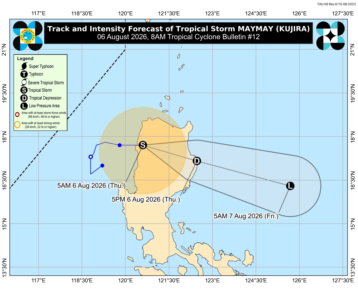
Tropical Storm Maymay’s forecast track and intensity (PAGASA)
The Philippine Atmospheric, Geophysical and Astronomical Services Administration (PAGASA) said Tropical Storm Maymay (international name “Kujira”) is expected to further lose strength while crossing Northern Luzon on Thursday, Aug. 6.
Maymay made landfall over Magsingal, Ilocos Sur at around 2 a.m. Thursday.
As of 7 a.m., its center was located over Bangued, Abra with maximum sustained winds of 65 kilometers per hour (kph) near the center and gustiness of up to 110 kph.
It was moving eastward at 10 kph.
PAGASA weather specialist Leanne Loreto said the storm is expected to weaken further as it traverses the mountainous terrain of Northern Luzon.
“Asahan natin habang tumatawid sa mga bulubunduking lugar sa Northern Luzon ay mas hihina na itong bagyo (We expect the storm to weaken further as it crosses the mountainous areas of Northern Luzon),” Loreto said.
“Ngunit asahan pa rin po na may malalakas na hangin at malalakas na mga pag-ulan dulot nitong Bagyong Maymay sa Northern and Central Luzon ngayong araw (However, we still expect strong winds and heavy rains from Tropical Storm Maymay over Northern and Central Luzon today),” she added.
As of PAGASA's 8 a.m. bulletin, Tropical Cyclone Wind Signal No. 2 remained hoisted over Ilocos Norte; the northern and central portions of Ilocos Sur (Gregorio del Pilar, Magsingal, San Esteban, Banayoyo, Cervantes, Burgos, City of Candon, Santa Lucia, Santiago, San Vicente, Santa Catalina, Lidlidda, Nagbukel, Sinait, Suyo, Sigay, San Ildefonso, Galimuyod, Quirino, City of Vigan, San Emilio, Cabugao, Caoayan, San Juan, Santa, Bantay, Santo Domingo, Tagudin, Santa Cruz, Santa Maria, Narvacan, Salcedo); the western portion of Apayao (Conner, Kabugao, Calanasan); Abra; the western and central portions of Kalinga (Pasil, Tinglayan, Balbalan, Lubuagan, Pinukpuk, City of Tabuk, Tanudan); and the western and central portions of Mountain Province (Besao, Tadian, Bauko, Sagada, Sabangan, Bontoc, Sadanga, Barlig, Natonin).
Meanwhile, Tropical Cyclone Wind Signal No. 1 remained in effect over the rest of Ilocos Sur, La Union, the northwestern portion of Pangasinan (Bolinao, Anda, Bani), the rest of Apayao, the rest of Kalinga, the rest of Mountain Province, Ifugao, Benguet, the southern portion of the Babuyan Islands (Calayan Island, Dalupiri Island, Fuga Island, Camiguin Island), mainland Cagayan, Isabela, Quirino, Nueva Vizcaya, and the northern and central portions of Aurora (Dilasag, Casiguran, Dinalungan, Dipaculao).
PAGASA said Maymay is forecast to continue weakening while moving farther inland.
“Maymay is forecast to continue weakening while moving further inland. It will weaken into a tropical depression likely this morning and may be downgraded into a remnant low this afternoon or evening,” the agency said.
“However, due to interaction with the rugged terrain, an earlier weakening is possible. The remnant low of Maymay will move generally southeastward until it merges into the larger circulation of Tropical Cyclone Dolphin,” it added.
Loreto said that by Friday, Aug. 7, Maymay is expected to have weakened into a low-pressure area, leaving the southwest monsoon or "habagat" as the country's dominant weather system.
Typhoon outside PAR to keep enhancing ‘habagat’
Even as Maymay weakens, PAGASA said the typhoon with the international name “Dolphin” is expected to continue enhancing the southwest monsoon until the weekend.
As of Thursday morning, Dolphin was located 1,450 kilometers east northeast of extreme Northern Luzon, moving along the northern boundary of the Philippine Area of Responsibility (PAR) and remaining far from land.
Loreto said Dolphin will continue pulling the southwest monsoon toward Luzon and the western sections of the Visayas.
“Dito naman sa Southern Luzon area, maging sa western section ng Visayas, inaasahan naman natin yung epekto ng habagat o yung southwest monsoon so expect po natin na magiging maulan pa rin sa Metro Manila, Calabarzon, Mimaropa, and Antique. Inaasahan natin ang mga panaka-nakang pag-ulan at kalat-kalat na mga pagkulog-pagkidlat ngayong araw (In Southern Luzon and the western section of the Visayas, we expect the effects of the southwest monsoon, so Metro Manila, Calabarzon, Mimaropa, and Antique will continue to experience rainy weather. Intermittent rains and scattered thunderstorms are expected today),” she said.
“Expect po natin kahit wala na ang Bagyong Maymay ay patuloy yung mga pag-ulan bukas hanggang over the weekend sa Luzon at western sections of Visayas dahil sa habagat na pinalakas nitong bagyong Dolphin (We expect that even after Maymay is gone, rains will continue from Friday through the weekend over Luzon and the western sections of the Visayas because of the southwest monsoon being enhanced by Typhoon Dolphin),” Loreto added.
PAGASA said the rest of the country will generally experience fair weather, although localized thunderstorms remain possible, especially in the afternoon or evening.
Loreto advised the public to remain alert for possible flash floods and landslides, especially in areas that have experienced continuous rainfall over the past few days, as the already saturated soil increases the risk of flooding and landslides.