






Manila Bulletin
 Philippines
National
PAGASA raises Signal No. 2 over 6 Luzon areas as 'Maymay' becomes tropical storm
Philippines
National
PAGASA raises Signal No. 2 over 6 Luzon areas as 'Maymay' becomes tropical storm
Philippines
National
PAGASA raises Signal No. 2 over 6 Luzon areas as 'Maymay' becomes tropical storm
PAGASA raises Signal No. 2 over 6 Luzon areas as 'Maymay' becomes tropical storm
Published Aug 5, 2026 06:35 am


At A Glance
- As of 4 a.m., the center of Tropical Storm Maymay was estimated 170 kilometers west northwest of Bacnotan, La Union.
- PAGASA said Maymay will move generally eastward and may make landfall over Ilocos Sur or La Union by this afternoon or evening before traversing the landmass of Northern and Central Luzon until Thursday, Aug. 6.
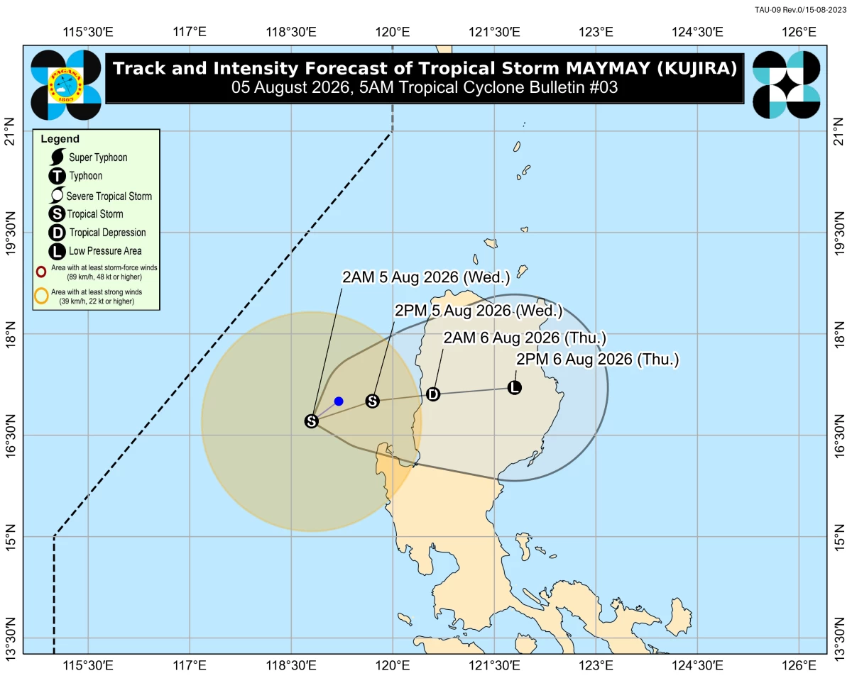
Tropical Storm Maymay’s forecast track and intensity (PAGASA)
Tropical Depression Maymay (international name “Kujira”) intensified into a tropical storm early Wednesday, Aug. 5, prompting the Philippine Atmospheric, Geophysical and Astronomical Services Administration (PAGASA) to raise Tropical Cyclone Wind Signal No. 2 over parts of Northern Luzon.
As of 4 a.m., the center of Tropical Storm Maymay was estimated 170 kilometers west northwest of Bacnotan, La Union.
It was packing maximum sustained winds of 65 kilometers per hour (kph) near the center, gusts of up to 80 kph, and was moving slowly southeastward.
PAGASA raised Signal No. 2 over the central and southern portions of Ilocos Sur (Gregorio del Pilar, Magsingal, San Esteban, Banayoyo, Cervantes, Burgos, City of Candon, Santa Lucia, Santiago, San Vicente, Santa Catalina, Lidlidda, Nagbukel, Suyo, Sigay, San Ildefonso, Galimuyod, Quirino, City of Vigan, San Emilio, Caoayan, Alilem, San Juan, Santa, Bantay, Santo Domingo, Sugpon, Tagudin, Santa Cruz, Santa Maria, Narvacan, Salcedo), the northern and central portions of La Union (Luna, Caba, Santol, Bauang, City of San Fernando, San Juan, Bagulin, Aringay, Bangar, San Gabriel, Burgos, Naguilian, Bacnotan, Sudipen, Balaoan), the northwestern portion of Pangasinan (Anda, Bolinao, Bani), the southwestern portion of Abra (Manabo, Pidigan, Langiden, Luba, Boliney, Sallapadan, Bucloc, Tubo, Villaviciosa, Pilar, Peñarrubia, San Isidro, San Quintin, Bangued, Bucay), the western portion of Mountain Province (Besao, Tadian), and the northwestern portion of Benguet (Mankayan, Kapangan, Kibungan, Sablan, Bakun).
Signal No. 1 remains in effect over Ilocos Norte, the rest of Ilocos Sur, the rest of La Union, the rest of Pangasinan, Apayao, the rest of Abra, Kalinga, the rest of Mountain Province, Ifugao, the rest of Benguet, Cagayan, Isabela, Quirino, Nueva Vizcaya, the northern portion of Zambales (Candelaria, Santa Cruz, Masinloc, Palauig), the northern portion of Tarlac (Mayantoc, San Clemente, Camiling, Santa Ignacia, Gerona, Paniqui, Moncada, San Manuel, Anao, Ramos, Pura), the northern portion of Nueva Ecija (Carranglan, Lupao, Cuyapo, Talugtug, Nampicuan, Guimba, Science City of Muñoz, San Jose City, Pantabangan), and the northern portion of Aurora (Dilasag, Casiguran, Dinalungan, Dipaculao).
Landfall
PAGASA said Maymay will move generally eastward and may make landfall over Ilocos Sur or La Union by Wednesday afternoon or evening before traversing the landmass of Northern and Central Luzon until Thursday, Aug. 6.
The weather bureau said Maymay is forecast to remain a tropical storm as it approaches the Philippine landmass.
After making landfall, it is expected to weaken into a tropical depression by Thursday morning and may further weaken into a low pressure area by Thursday afternoon or evening.
PAGASA pointed out that heavy rainfall and severe winds may still be experienced in localities outside the forecast landfall point and the forecast confidence cone.
It added that the cyclone's track may still shift within the limits of the forecast confidence cone.
Heavy rainfall outlook
PAGASA said Maymay is expected to bring stormy weather over Ilocos Sur, La Union, Pangasinan, Benguet, Mountain Province, and Abra.
Rains with gusty winds are also forecast over Cagayan Valley, the rest of the Ilocos Region, the rest of the Cordillera Administrative Region, Zambales, Tarlac, and Nueva Ecija.
The rest of Central Luzon may experience scattered rains and thunderstorms.
Meanwhile, the southwest monsoon or "habagat" may bring scattered rains and thunderstorms over Metro Manila, Cavite, Laguna, Rizal, Quezon, Occidental Mindoro, Oriental Mindoro, Marinduque, Antique, Iloilo, and Guimaras.
Typhoon Dolphin
PAGASA said the typhoon outside the Philippine Area of Responsibility (PAR), internationally named Dolphin, was located 1,845 kilometers east northeast of extreme Northern Luzon as of 4 a.m.
Dolphin was moving westward at 20 kph while packing maximum sustained winds of 165 kph near the center and gusts of up to 205 kph.
Although it is less likely to enter the PAR, PAGASA said the typhoon may further enhance the southwest monsoon over the next few days, contributing to more rains through the weekend.