






Manila Bulletin
 Philippines
National
LPA intensifies into tropical depression; rains seen over parts of the Philippines in next 4 days
Philippines
National
LPA intensifies into tropical depression; rains seen over parts of the Philippines in next 4 days
Philippines
National
LPA intensifies into tropical depression; rains seen over parts of the Philippines in next 4 days
LPA intensifies into tropical depression; rains seen over parts of the Philippines in next 4 days
Published Jun 19, 2026 08:28 am
|
Updated Jun 19, 2026 01:44 pm


At A Glance
- Due to the trough of the tropical cyclone, PAGASA weather specialist Obet Badrina said cloudy skies with scattered rains and thunderstorms may prevail over the Visayas and Mindanao from Saturday to Sunday, June 20 to 21.
- From Monday to Tuesday, June 22 to 23, cloudy skies with scattered rains and thunderstorms may persist in the western section of Mindanao, the Visayas, and Southern Luzon due to the tropical cyclone-enhanced southwest monsoon or "habagat."
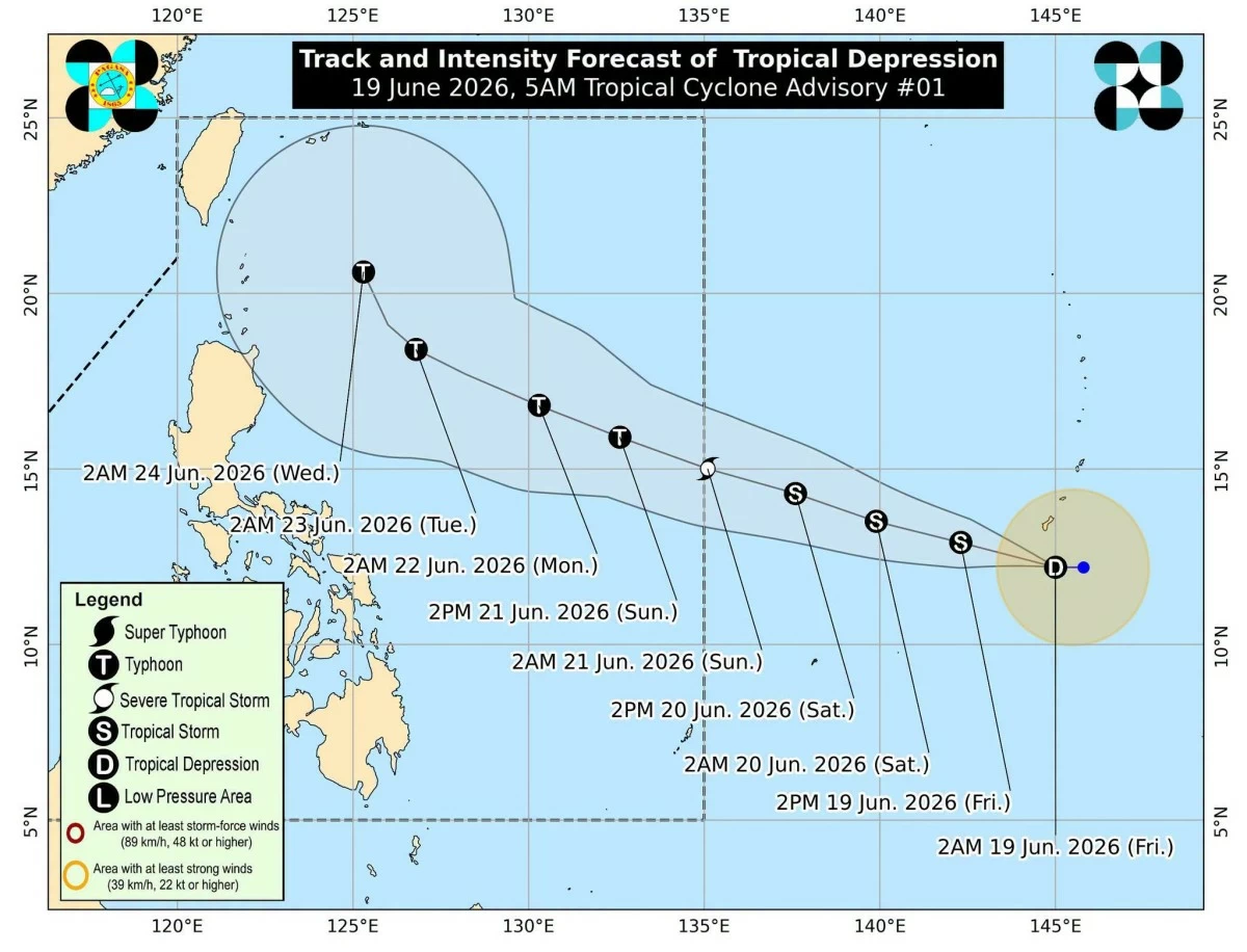
Track and intensity forecast for the tropical depression spotted outside the Philippine area of responsibility. (PAGASA)
The low-pressure area (LPA) being monitored east of the country has intensified into a tropical depression on Friday, June 19, and is expected to enter the Philippine Area of Responsibility (PAR) this weekend, according to the Philippine Atmospheric, Geophysical and Astronomical Services Administration (PAGASA).
PAGASA weather specialist Obet Badrina said the tropical depression was located 2,085 kilometers east of Eastern Visayas as of 3 a.m.
It has maximum sustained winds of 55 kilometers per hour (kph) near the center and gustiness of up to 70 kph. It was moving westward at 15 kph.
The tropical cyclone has no direct effect on any part of the country at present.
“Inaasahan po natin na ito ay papasok sa Philippine Area of Responsibility by tomorrow late evening o madaling araw ng Linggo (We expect it to enter the Philippine Area of Responsibility by late Saturday evening or in the early hours of Sunday),” Badrina said.
Once inside PAR, the tropical cyclone will be assigned the local name “Francisco.”
“Ang posibleng maging track nito ay kikilos kanluran-hilagang kanluran at sa ngayon maliit ang posibilidad na tumama sa kalupaan ng ating bansa (Its possible track is toward the west-northwest, and at present there is only a small chance that it will make landfall in the country),” he added.
Although the tropical cyclone may not hit land, PAGASA warned that it may trigger the resurgence of the southwest monsoon, or “habagat,” by Sunday, June 21, when it is also expected to intensify into a typhoon.
Due to the trough of the tropical cyclone, Badrina said cloudy skies with scattered rains and thunderstorms may prevail over the Visayas and Mindanao from Saturday to Sunday, June 20 to 21.
From Monday to Tuesday, June 22 to 23, cloudy skies with scattered rains and thunderstorms may persist in the western section of Mindanao, the Visayas, and Southern Luzon due to the tropical cyclone-enhanced southwest monsoon.
Meanwhile, easterlies, or warm winds from the Pacific Ocean, continue to affect the rest of the country, bringing isolated rain showers and thunderstorms.
PAGASA warned the public of possible flash floods or landslides, especially in areas experiencing severe thunderstorms.