


'Ada' may intensify into severe tropical storm — PAGASA
Published Jan 17, 2026 02:11 pm


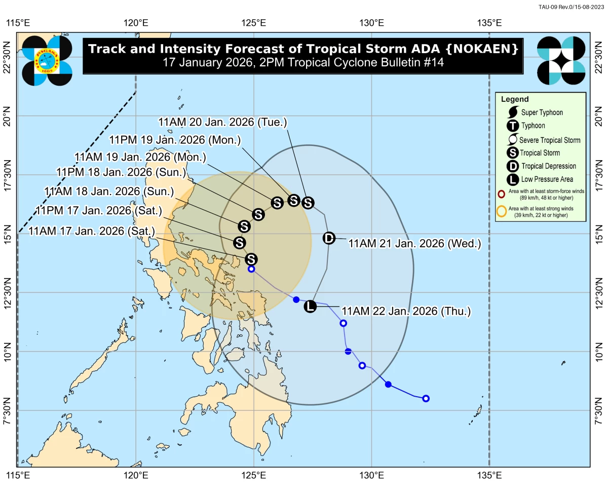
Track and intensity forecast for Tropical Storm Ada (Nokaen) (Courtesy of PAGASA)
The Philippine Atmospheric, Geophysical and Astronomical Services Administration (PAGASA) on Saturday, Jan. 17, warned that Tropical Storm Ada (international name: Nokaen) could intensify into a severe tropical storm while lingering east of Southern Luzon.
As of 11 a.m., the center of Ada was located 95 kilometers east-northeast of Virac, Catanduanes, or 220 kilometers east of Daet, Camarines Norte.
It was moving northward at 15 kilometers per hour (kph), with maximum sustained winds of 85 kph near the center and gustiness reaching 105 kph.
PAGASA said the storm’s current intensity is already capable of producing damaging winds across parts of the Bicol Region and Eastern Visayas.
Minor to moderate impacts from gale-force winds remain possible in areas under Tropical Cyclone Wind Signal No. 2, while minimal to minor wind impacts are expected in areas under Signal No. 1.
PAGASA also noted that the raising of Tropical Cyclone Wind Signal No. 3 remains possible should Ada strengthen further.
Signal No. 2 remained in effect over the eastern portion of Camarines Norte (Vinzons, San Lorenzo Ruiz, San Vicente, Talisay, Basud, Mercedes, Daet, Paracale); the eastern and central portions of Camarines Sur (Siruma, Tinambac, Ocampo, Goa, Lagonoy, Milaor, Nabua, Buhi, Caramoan, Baao, Cabusao, Bato, Camaligan, Pili, Sipocot, Tigaon, Pamplona, Garchitorena, Iriga City, San Fernando, Magarao, Minalabac, Balatan, Libmanan, Naga City, Calabanga, Bombon, Bula, Canaman, Pasacao, Sagñay, San Jose, Presentacion, Gainza, Lupi); Catanduanes; Albay; and the northern portion of Sorsogon (City of Sorsogon, Barcelona, Magallanes, Pilar, Castilla, Gubat, Casiguran, Donsol, Juban, Prieto Diaz).
Meanwhile, Signal No. 1 was still in effect over the eastern portion of Quezon (Tagkawayan, Guinayangan, Lopez, Calauag, Buenavista, San Narciso, San Andres, San Francisco, Mulanay, Catanauan, General Luna, Macalelon, Gumaca, Pitogo, Unisan, Atimonan, Plaridel, Agdangan, Padre Burgos, Quezon, Alabat, Perez, Polillo Islands); Marinduque; the eastern portion of Romblon (Cajidiocan, Magdiwang, San Fernando); the rest of Camarines Norte; the rest of Camarines Sur; the rest of Sorsogon; Masbate; Northern Samar; Eastern Samar; Samar; Biliran; the northern portion of Leyte (Carigara, Barugo, San Miguel, Babatngon, Tacloban City, Tunga, Jaro, Alangalang, Santa Fe, Palo, Dagami, Pastrana, Tanauan, Tabontabon, Julita, Dulag, Tolosa, La Paz, Mayorga, Macarthur, Kananga, Capoocan, Leyte, Calubian, San Isidro, Tabango, Burauen, Ormoc City, Matag-ob, Villaba, Albuera, Palompon, Merida, Isabel); and the northern portion of Cebu (Medellin, Daanbantayan, Bantayan Islands).
PAGASA said Ada is expected to move generally northwestward within the day before slowly turning northward to northeastward on Sunday, Jan. 18.
From Sunday onward, the cyclone may move slowly in a looping pattern over the sea east of Southern Luzon, prolonging the period of strong winds over affected areas.
A slight westward shift in Ada’s track could bring the storm closer to land, with a possible landfall over Catanduanes.
While Ada is forecast to remain a tropical storm over the sea east of Southern Luzon, PAGASA said it is likely to weaken into a tropical depression by Tuesday afternoon or evening, Jan. 20, as the surge of the northeast monsoon, or “amihan,” begins to affect the weather disturbance.