






Manila Bulletin
 Philippines
National
Forest fire particles from Indonesia reaching Philippines due to strong 'habagat', says PAGASA
Philippines
National
Forest fire particles from Indonesia reaching Philippines due to strong 'habagat', says PAGASA
Philippines
National
Forest fire particles from Indonesia reaching Philippines due to strong 'habagat', says PAGASA
Forest fire particles from Indonesia reaching Philippines due to strong 'habagat', says PAGASA
Published Sep 1, 2026 02:32 pm


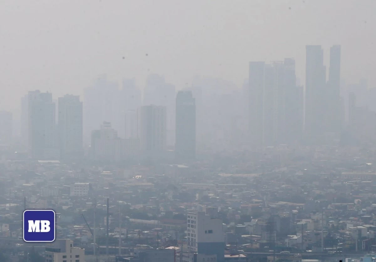
A blanket of haze covers the Metro Manila skyline on Sept. 1, 2026, as particles from forest and land fires in Kalimantan, Indonesia reach parts of the Philippines. (Mark Balmores/Manila Bulletin)
The hazy conditions being observed over parts of the country are associated with particles from forest fires in Kalimantan, Indonesia, which are being transported by the prevailing southwest monsoon or “habagat,” according to the Philippine Atmospheric, Geophysical and Astronomical Services Administration (PAGASA).
PAGASA weather specialist Benison Estareja said on Tuesday, Sept. 1, that the southwest monsoon remains relatively strong.
“The prevailing weather system kasi natin sa ngayon at sa mga susunod na araw ay yung southwest monsoon pa rin at relatively hindi pa rin siya magiging mahina (The prevailing weather system we have now and in the coming days will still be the southwest monsoon, and it will remain relatively strong),” Estareja said during a press conference.
“So, we're seeing na habang mayroon ditong forest fires sa may kalagitnaan, sa may bandang Kalimantan, Indonesia, posible pa rin magkaroon ng transport ng particles from this part of Sabah patungo dito sa may parteng Southern Luzon (So, we're seeing that while there are forest fires around Kalimantan, Indonesia, there could still be transport of particles from this part of Sabah toward Southern Luzon),” he said.
However, Estareja said the areas that could be affected may vary depending on the orientation of the habagat.
“So, depende pa rin. Medyo nagva-vary lang po ng kaunti yung mga posibleng puntahan na mga lugar but it could range from somewhere dito sa may Central Luzon, maaaring pababa dito sa may Visayas, depende doon sa orientation ng habagat natin (So, it still depends. The areas where the particles could go may vary somewhat, but they could range from somewhere in Central Luzon down to the Visayas, depending on the orientation of the habagat),” he said.
Meanwhile, PAGASA Climate Monitoring and Prediction Section chief Ana Liza Solis said forest fires in Indonesia are a recurring phenomenon during strong El Niño events, citing the 2015 episode as an example.
“Yung forest fires sa Indonesia, so yun po ay recurrent po. Nangyayari po yun during strong El Niño event. Nangyari din na po yun noong 2015 (The forest fires occurring in Indonesia are a recurring phenomenon. They happen during strong El Niño events, as they did in 2015),” Solis said.
She recalled that previous forest fires in Indonesia affected parts of the Visayas and Mindanao, where declining visibility also became a concern for airport operations.
“So yun din po, yung mga airport station din po natin ay kailangan din po nating observahan (So, our airport stations also need to be monitored),” she said.
Estareja said the weather being experienced over the affected areas remains mainly due to the southwest monsoon.
Despite the transport of particles, moisture from the Indian Ocean and West Philippine Sea will continue to trigger rainfall, Estareja said.
“So, bagamat mayroon tayong transport ng mga particles, meron pa rin naman tayong moisture na manggagaling dito sa may Indian Ocean at West Philippine Sea na siya magti-trigger pa rin ng mga pag-ulan (So, although there is transport of particles, we will still have moisture coming from the Indian Ocean and West Philippine Sea that will continue to trigger rainfall),” he said.
Weather update
Meanwhile, several weather disturbances north and east of the Philippines are enhancing the habagat, PAGASA said on Tuesday.
Tropical Storm Pilandok, with the international name “Krovahn,” was located 1,060 kilometers east of extreme Northern Luzon as of 10 a.m.
While it remains inside the Philippine Area of Responsibility (PAR), it is still too far from the country’s landmass to have a direct effect on the Philippines.
Pilandok is forecast to exit the PAR by Wednesday evening, Sept. 2, or Thursday morning, Sept. 3.
PAGASA is also monitoring a low-pressure area (LPA) that weakened from a tropical depression.
It was located 645 kilometers west-northwest of Batanes and is unlikely to re-intensify into a tropical depression.
Another tropical storm, Saudel, the former Tropical Depression Obet that passed through the northern Philippine Sea, was located 805 kilometers west of extreme Northern Luzon.
“Halos dalawang linggo na ang nakalipas nung pumasok sa PAR pero ngayon po ay parang nagbabadya po ito na bumalik muli ng ating area of responsibility sa mga susunod na araw (It entered the PAR almost two weeks ago, but now it appears to be threatening to return to our area of responsibility in the coming days),” Estareja said.
A low-pressure area was also last seen far east of Southern Luzon, almost 3,000 kilometers away.
Estareja said the LPA is still too far away to have any immediate impact.