







Three cyclones stir 'habagat' — PAGASA
Rainy weather to persist over parts of Luzon, Western Visayas
Published Aug 31, 2026 09:31 am


At A Glance
- PAGASA weather specialist Aldczar Aurelio said some areas may continue to receive heavy to intense rainfall due to the enhanced southwest monsoon or "habagat."
PAGASA
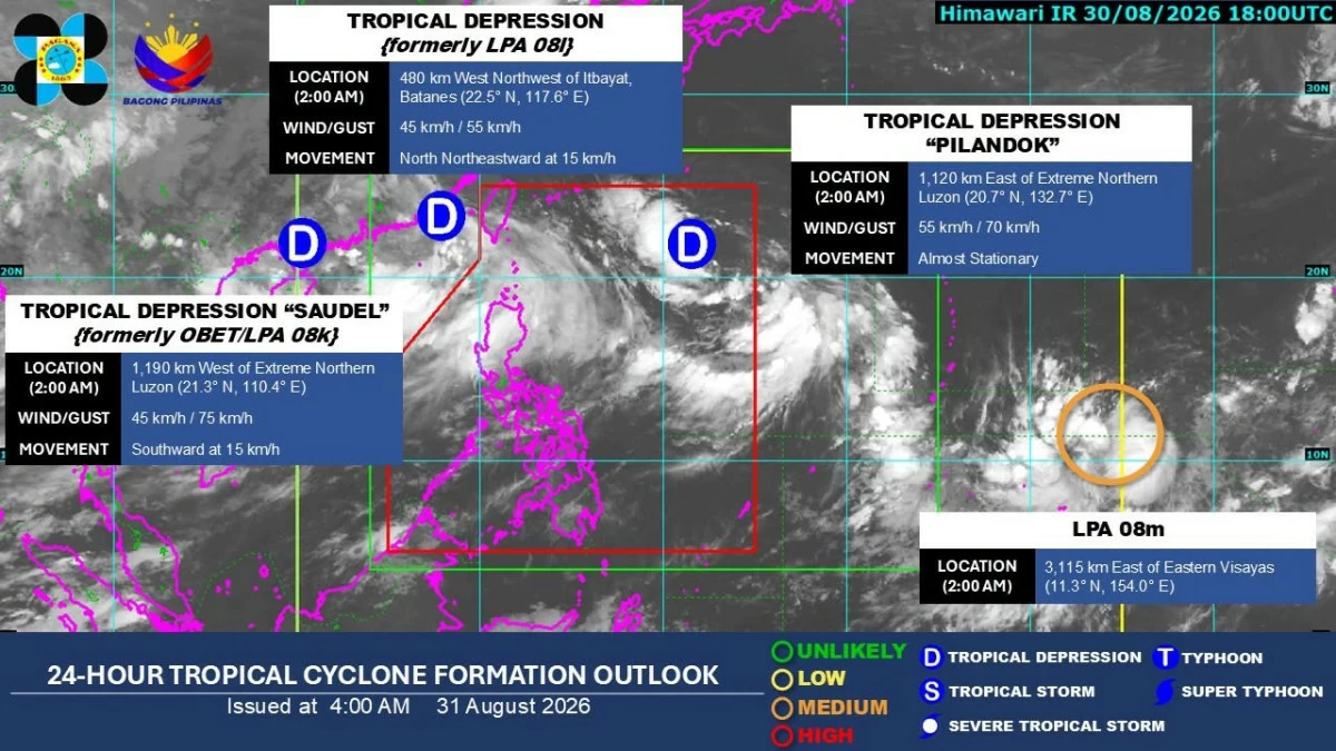
Parts of Luzon and the western section of the Visayas can expect rainy weather as three tropical cyclones continue to enhance the southwest monsoon or “habagat,” the Philippine Atmospheric, Geophysical and Astronomical Services Administration (PAGASA) said on Monday, Aug. 31.
PAGASA weather specialist Aldczar Aurelio said some areas may continue to receive heavy to intense rainfall.
“Itong tatlong bagyong ito ay pinapalakas o ineenhance ang southwest monsoon or habagat. Kaya itong habagat ay nakakaapekto pa rin sa Luzon at sa western section ng Visayas kaya makakaasa pa rin tayo ngayong araw ng mga maulan na panahon lalo na ang malaking bahagi ng Luzon kasama ang Metro Manila (These three storms are strengthening or enhancing the southwest monsoon or habagat. That is why the habagat continues to affect Luzon and the western section of the Visayas, so we can expect rainy weather today, especially over much of Luzon, including Metro Manila),” Aurelio said.
One of the three systems is Tropical Depression Pilandok, which slightly strengthened while remaining far from the Philippine landmass.
As of 4 a.m., Pilandok was located 1,130 kilometers east of extreme Northern Luzon.
It had maximum sustained winds of 55 kilometers per hour (kph) near the center and gustiness of up to 70 kph.
Pilandok was almost stationary but may move generally north-northwestward in the coming days.
“Mababa ang tsansa na maglandfall ang bagyo at mababa ang tsansa na magtaas tayo ng tropical cyclone wind signal (There is a low chance that the storm will make landfall and a low chance that we will raise a tropical cyclone wind signal),” Aurelio said.
PAGASA said Pilandok may exit the Philippine Area of Responsibility (PAR) by Wednesday evening, Sept. 2, or Thursday morning, Sept. 3.
The tropical depression may maintain its strength over the next 24 hours and could briefly intensify into a tropical storm by Tuesday afternoon, Sept. 1, before weakening into a tropical depression by Wednesday morning.
However, PAGASA said the forecast track remains highly uncertain and may change in succeeding bulletins.
Aurelio said the low-pressure area (LPA), designated LPA 08l, intensified into a tropical depression on Monday morning.
It was located 485 kilometers west-northwest of Itbayat, Batanes as of 3 a.m. and was moving north-northeastward at 15 kph.
Meanwhile, Tropical Depression Saudel, formerly known as “Obet,” was located 1,180 kilometers west of extreme Northern Luzon, outside the PAR.
Aurelio said the three tropical cyclones were helping strengthen the habagat, which is why rainy conditions will continue over several areas.
Meanwhile, another LPA outside the PAR, designated LPA 08m, was located 3,105 kilometers east of the Visayas.
Aurelio said LPA 08m has no direct effect on the country's weather at present and is not enhancing the habagat.
Heavy rainfall
PAGASA's rainfall outlook due to the southwest monsoon showed that several areas may receive 100 to 200 millimeters of rain, classified as heavy to intense, on Monday.
These are Ilocos Norte, Ilocos Sur, La Union, Abra, Pangasinan, Benguet, Zambales, Bataan, Tarlac, and Pampanga.
Batanes, Apayao, Kalinga, Ifugao, Mountain Province, Nueva Vizcaya, Nueva Ecija, and Bulacan may receive 50 to 100 millimeters, classified as moderate to heavy.
On Tuesday, Ilocos Norte, Ilocos Sur, La Union, Abra, Benguet, Zambales, and Bataan may receive 100 to 200 millimeters of rain.
Pangasinan, Apayao, Kalinga, Ifugao, Mountain Province, Batanes, Tarlac, and Pampanga may receive 50 to 100 millimeters.
On Wednesday, Ilocos Norte, Ilocos Sur, Abra, and Benguet may receive 100 to 200 millimeters, while Batanes, Apayao, Kalinga, Ifugao, Mountain Province, La Union, Pangasinan, Tarlac, Pampanga, Zambales, and Bataan may receive 50 to 100 millimeters.