







LPA develops into tropical depression 'Pilandok'
Published Aug 30, 2026 10:35 am


At A Glance
- As of 10 a.m., the center of Tropical Depression Pilandok was estimated at 1,210 kilometers east of extreme Northern Luzon.
- PAGASA said the tropical depression is less likely to make landfall over the country and is expected to remain far from the Philippine landmass.
- For now, the southwest monsoon or "habagat" remains the weather system mainly affecting Luzon.
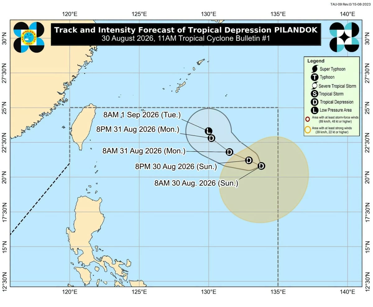
Tropical Depression Pilandok track and intensity forecast (PAGASA)
The low-pressure area (LPA) inside the Philippine Area of Responsibility (PAR) has developed into a tropical depression and was locally named “Pilandok,” the Philippine Atmospheric, Geophysical and Astronomical Services Administration (PAGASA) said on Sunday, Aug. 30.
As of 10 a.m., the center of Tropical Depression Pilandok was estimated at 1,210 kilometers east of extreme Northern Luzon.
It was moving west-northwestward at 15 kilometers per hour (kph), with maximum sustained winds of 45 kph near the center and gustiness of up to 55 kph.
Pilandok is expected to continue moving west-northwestward through Monday, Aug. 31, before turning northwestward to north-northwestward for the remainder of the forecast period.
PAGASA said the tropical depression is less likely to make landfall over the country and is expected to remain far from the Philippine landmass.
The weather disturbance is also expected to be short-lived and remain a tropical depression throughout the forecast period before weakening into a remnant low over the Philippine Sea south of the southern islands of Japan on Tuesday, Sept. 1.
PAGASA weather specialist Obet Badrina earlier said the agency would continue to monitor how Pilandok interacts with the southwest monsoon or “habagat.”
For now, the habagat remains the weather system mainly affecting Luzon.
The rainfall outlook for Sunday showed that Ilocos Sur, Pangasinan, La Union, Benguet, Bataan, Zambales, Tarlac, and Pampanga could receive 100 to 200 millimeters of rain, considered heavy to intense.
Metro Manila, Ilocos Norte, Abra, Apayao, Kalinga, Ifugao, Mountain Province, Nueva Vizcaya, Nueva Ecija, Bulacan, Rizal, Cavite, Laguna, Batangas, and Occidental Mindoro could receive 50 to 100 millimeters of rain, considered moderate to heavy.
On Monday, Aug. 31, 100 to 200 millimeters of rain could affect Ilocos Norte, Ilocos Sur, La Union, Pangasinan, Abra, Benguet, Zambales, and Bataan.
Fifty to 100 millimeters of rain could prevail over Apayao, Kalinga, Ifugao, Mountain Province, Tarlac, Pampanga, Bulacan, Metro Manila, Rizal, Cavite, Batangas, and Occidental Mindoro.
By Tuesday, Sept. 1, 100 to 200 millimeters of rain could affect Ilocos Norte, Ilocos Sur, Abra, Benguet, and Zambales.
Batanes, Apayao, Kalinga, Ifugao, Mountain Province, La Union, Pangasinan, Tarlac, Bataan, and Pampanga could receive 50 to 100 millimeters of rainfall.
Despite the possibility that Pilandok could strengthen the habagat, Badrina earlier said rainfall over the western section of Luzon could decrease by Monday or Tuesday.
The public was nevertheless urged to remain alert for possible flash floods and landslides, particularly in areas that could receive prolonged or heavy rainfall.