






Manila Bulletin
 Philippines
National
PAGASA monitors 2 LPAs with potential to become tropical depressions
Philippines
National
PAGASA monitors 2 LPAs with potential to become tropical depressions
Philippines
National
PAGASA monitors 2 LPAs with potential to become tropical depressions
PAGASA monitors 2 LPAs with potential to become tropical depressions
Published Aug 28, 2026 04:58 pm


At A Glance
- Two low-pressure areas are now being monitored by PAGASA after a new weather disturbance formed far east of Central Luzon on Friday afternoon, Aug. 28.
- Both have a "medium chance" of developing into tropical depressions within the next 24 hours.
- The next tropical cyclone names on PAGASA's list are "Pilandok" and "Queenie."
PAGASA
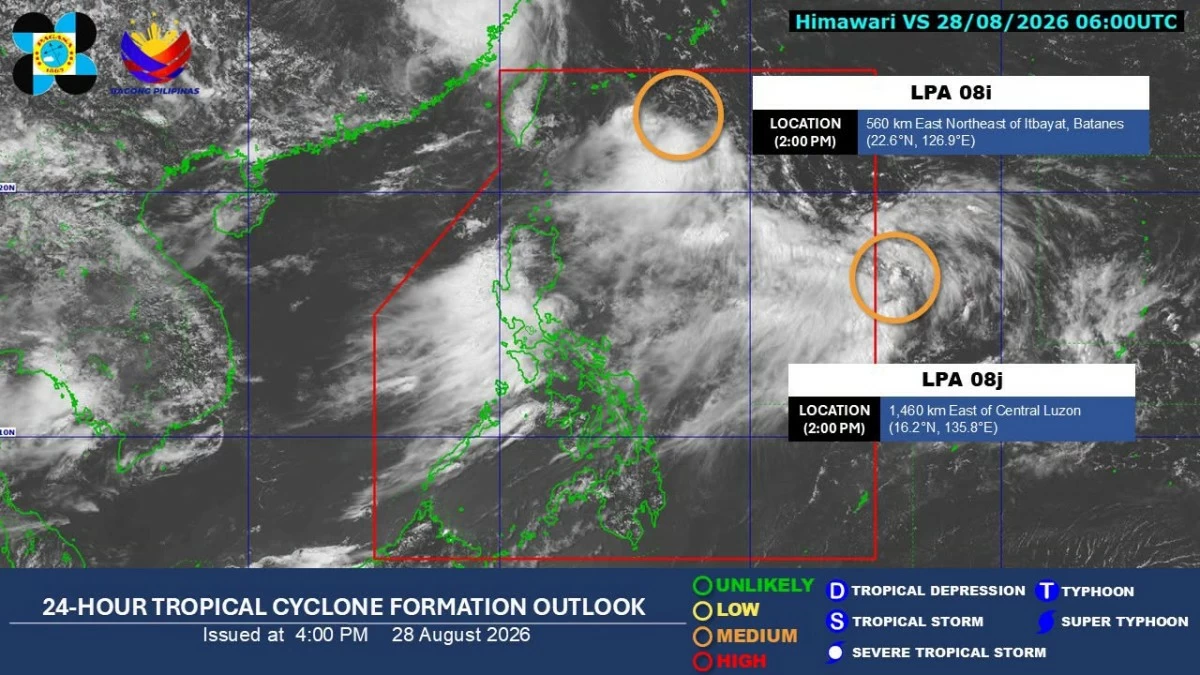
Two low-pressure areas (LPAs) are being monitored near the country, with both having a “medium chance” of developing into tropical depressions within the next 24 hours, the Philippine Atmospheric, Geophysical and Astronomical Services Administration (PAGASA) said on Friday, Aug. 28.
The LPA designated as LPA 08i, which has been monitored since Thursday, Aug. 27, was located 560 kilometers east-northeast of Itbayat, Batanes as of 2 p.m.
LPA 08i is expected to move toward Taiwan and is not forecast to make landfall over the Philippines.
Nevertheless, PAGASA said it continues to enhance the southwest monsoon or “habagat,” which is bringing rains over parts of Luzon.
Since LPA 08i is inside the Philippine Area of Responsibility (PAR), it will be given the local name “Pilandok” if it develops into a tropical depression.
Meanwhile, PAGASA said a new LPA designated as LPA 08j formed outside the PAR on Friday afternoon.
It was located 1,460 kilometers east of Central Luzon as of 2 p.m.
LPA 08j may also contribute to the strengthening of the habagat in the coming days.
If LPA 08j enters the PAR and develops into a tropical depression, it will be given the local name “Queenie.”
PAGASA said the enhanced southwest monsoon is expected to bring heavy rainfall over several Luzon areas this weekend.
From Friday to Saturday noon, Aug. 29, 100 to 200 millimeters of rainfall, considered heavy to intense, may affect La Union, Benguet, Bataan, Zambales, and Occidental Mindoro.
Meanwhile, 50 to 100 millimeters of rainfall, considered moderate to heavy, may persist over Metro Manila, Ilocos Sur, Pangasinan, Abra, Tarlac, Nueva Ecija, Pampanga, Bulacan, Rizal, Cavite, Batangas, and Oriental Mindoro.
From Saturday noon to Sunday noon, Aug. 30, 100 to 200 millimeters of rainfall may continue over Ilocos Sur, La Union, Pangasinan, Benguet, Zambales, and Bataan.
Fifty to 100 millimeters of rainfall may prevail over Metro Manila, Ilocos Norte, Abra, Tarlac, Nueva Ecija, Pampanga, Bulacan, Rizal, Cavite, Laguna, Batangas, Occidental Mindoro, and Oriental Mindoro.
From Sunday noon to Monday noon, Aug. 31, 100 to 200 millimeters of rainfall may persist over Ilocos Norte, Ilocos Sur, La Union, Pangasinan, Abra, Benguet, and Zambales.
Fifty to 100 millimeters of rainfall may affect Metro Manila, Batanes, Apayao, Kalinga, Ifugao, Mountain Province, Nueva Vizcaya, Tarlac, Nueva Ecija, Bataan, Pampanga, Bulacan, Rizal, Cavite, Batangas, and Occidental Mindoro.
PAGASA advised residents in areas that may experience heavy rainfall, particularly those prone to flooding and landslides, to remain alert and continue monitoring its latest weather updates.