







'Habagat' to bring heavy rains during long weekend — PAGASA
Published Aug 28, 2026 10:09 am


At A Glance
- PAGASA said heavy rains are expected to continue until Saturday, Aug. 29, and Sunday, Aug. 30, although they may ease by Sunday afternoon or Monday, Aug. 31, National Heroes Day.
- Significant rainfall may prevail over Ilocos Region, Bataan, Zambales, parts of Calabarzon, Metro Manila, Oriental Mindoro, and Occidental Mindoro.
- Another low-pressure area may form and could continue to strengthen the habagat next week.
PAGASA
Those looking forward to the long weekend may have to adjust their plans as the southwest monsoon or “habagat” is expected to bring heavy rains over parts of the country, particularly western Luzon.
Philippine Atmospheric, Geophysical and Astronomical Services Administration (PAGASA) weather specialist Obet Badrina said Friday, Aug. 28 that significant rainfall may prevail over Ilocos Region, Bataan, Zambales, parts of Calabarzon, Metro Manila, Oriental Mindoro, and Occidental Mindoro.
Heavy rains are expected to continue through Saturday, Aug. 29, and Sunday, Aug. 30, although they may ease by Sunday afternoon or Monday, Aug. 31, National Heroes Day.
“Partikular na sa Sabado at Linggo, inaasahan natin na magiging tuloy-tuloy ang mga malalakas na pag-ulan. Posibleng mabawasan po yan bandang hapon ng Linggo o Lunes na. Kaya sa mga kababayan natin na may activity this coming long weekend ay consider nating yung ineexpect na mga malalakas na pag-ulan lalong-lalo na sa western section nga ng western section ng Luzon (We expect the heavy rains to continue particularly on Saturday and Sunday. These may ease by Sunday afternoon or Monday. Those with activities this coming long weekend should consider the expected heavy rains, particularly over western Luzon),” Badrina said.
The rest of Luzon and Visayas may have scattered rains and thunderstorms, while Mindanao may generally have partly cloudy skies with isolated rain showers or thunderstorms.
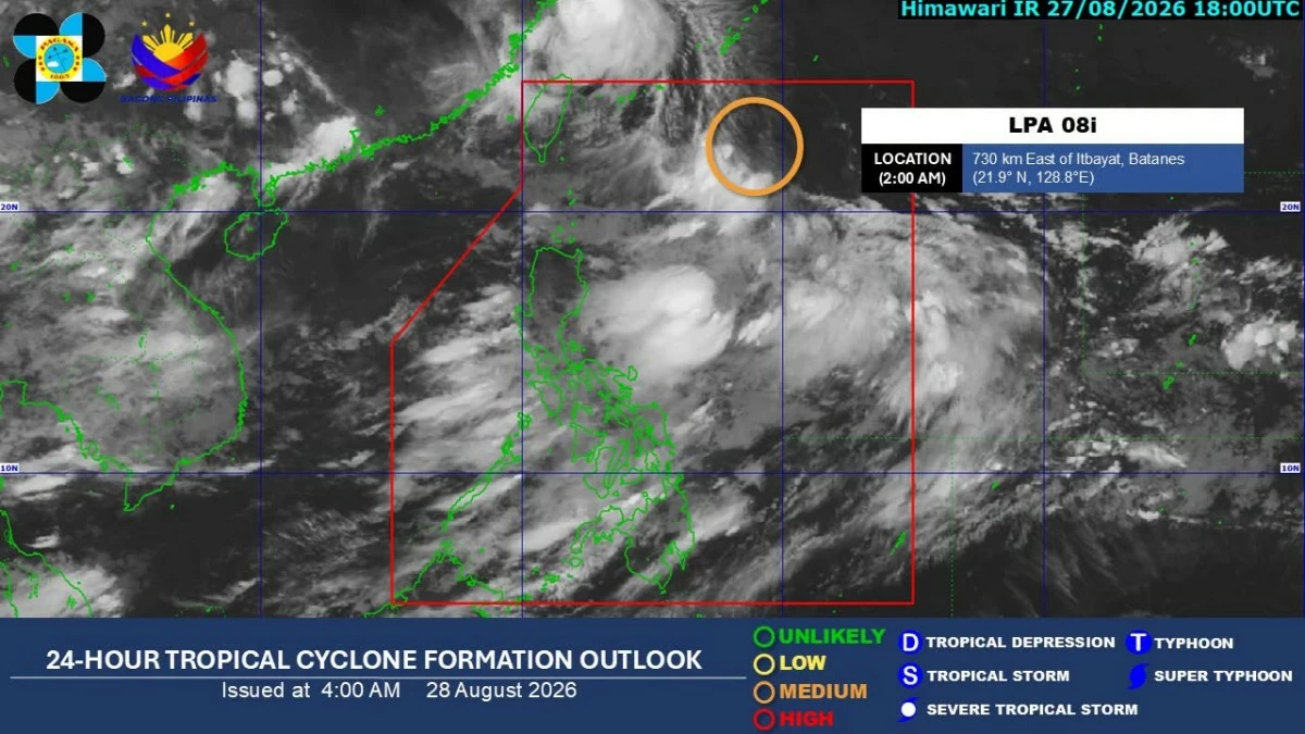
The low-pressure area (LPA), designated LPA 08i, was enhancing the habagat as it was located 720 kilometers east of Itbayat, Batanes as of 3 a.m. Friday.
The LPA could still develop into a tropical cyclone this weekend but is not expected to make landfall in the Philippines.
“Posible pa rin ito maging bagyo this coming weekend pero hindi na ito magkakaroon ng direktang epekto sa ating bansa. Hindi ito inaasahang maglandfall sa Pilipinas at ang magiging direksyon nitong low-pressure area na kung sakaling maging bagyo ay sa may bahagi naman ng Taiwan (It is still possible for this to become a tropical cyclone this coming weekend, but it will no longer have a direct effect on our country. It is not expected to make landfall in the Philippines, and if it becomes a tropical cyclone, the low-pressure area is expected to move toward Taiwan),” Badrina said.
If LPA 08i develops into a tropical depression, it will be given the local name “Pilandok.”
Another LPA could form next week and may further strengthen the habagat, Badrina said, citing PAGASA’s two-week tropical cyclone threat potential forecast.
“Around August 27 to September 2, inaasahan na ang low-pressure area na ating minomonitor ay patungo sa bahagi ng Taiwan. Samantala, by next week posibleng may mabuo na panibagong low-pressure area at maaaring magpatuloy na magpalakas ng habagat hanggang next week (Around August 27 to September 2, the low-pressure area we are monitoring is expected to move toward Taiwan. Meanwhile, by next week, another low-pressure area may form and could continue to strengthen the habagat into next week),” Badrina said.
He advised the public to continue monitoring PAGASA updates as longer-range forecasts are less certain and may still change.