






Manila Bulletin
 Philippines
National
LPA inside PAR may develop into tropical depression within 48 hours
Philippines
National
LPA inside PAR may develop into tropical depression within 48 hours
Philippines
National
LPA inside PAR may develop into tropical depression within 48 hours
LPA inside PAR may develop into tropical depression within 48 hours
Next tropical cyclone name on PAGASA's list is 'Pilandok'
Published Aug 27, 2026 08:37 am


At A Glance
- If LPA 08i develops into a tropical cyclone while inside the Philippine Area of Responsibility, it will be named "Pilandok."
- PAGASA's rainfall projections indicate heavy and potentially intense rains, particularly over northern and central Luzon, due to the enhanced southwest monsoon or "habagat."
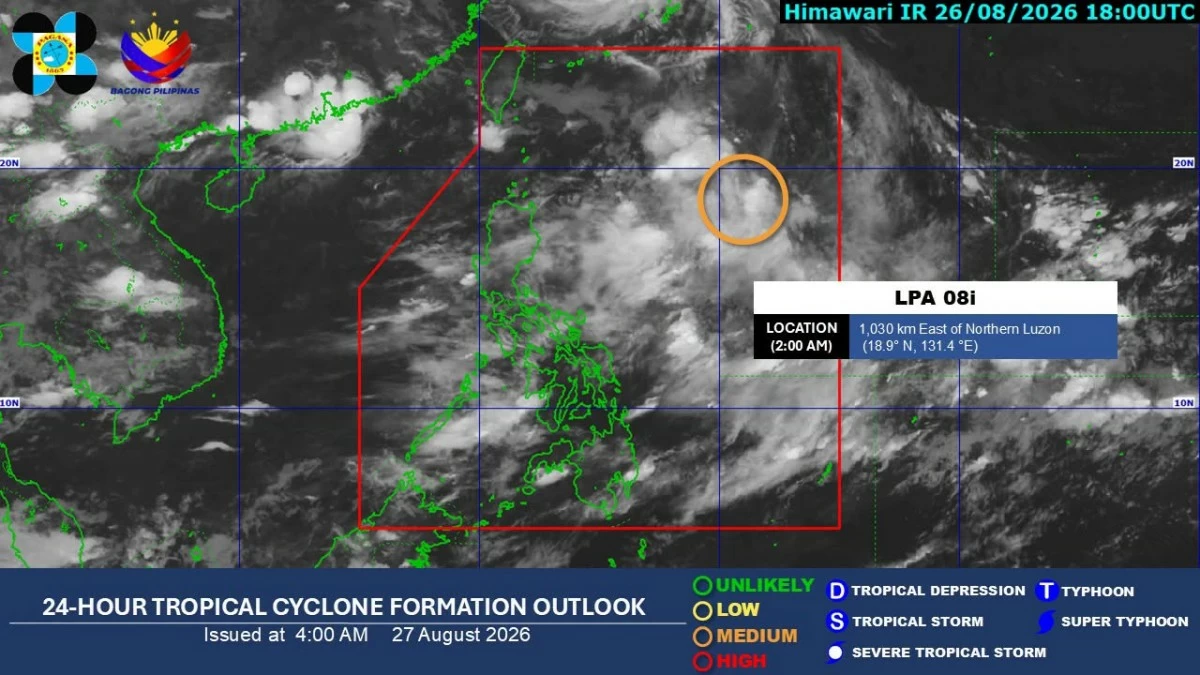
PAGASA
A new low-pressure area (LPA), designated as LPA 08i, developed early Thursday, Aug. 27, and has a “medium chance” of developing into a tropical depression within the next 48 hours, said the Philippine Atmospheric, Geophysical and Astronomical Services Administration (PAGASA).
PAGASA weather specialist Leanne Loreto said LPA 08i was located 1,030 kilometers east of Northern Luzon as of 2 a.m. Thursday.
If LPA 08i develops into a tropical cyclone while inside the Philippine Area of Responsibility, it will be named “Pilandok.”
Loreto said LPA 08i was moving northward over the north Philippine Sea as its cloud clusters continued to consolidate.
PAGASA expects it to eventually move west-northwestward toward Taiwan, making landfall in the country unlikely.
“Ang magiging indirect effect naman nitong LPA o yung potential na maging bagyo ay hihilahin nito yung habagat simula bukas hanggang sa Tuesday (The indirect effect of this LPA or potential tropical cyclone is that it will draw in the southwest monsoon from tomorrow until Tuesday, Sept. 1),” Loreto said.
“Sa nakikita nga natin, in the next few days, ay mas lalakas pa yung habagat habang kumikilos pa-west-northwestward itong LPA kaya magiging maulan sa Luzon, maging sa may western section ng Visayas in the next four to five days (Based on what we are seeing, the habagat will strengthen further in the next few days as the LPA moves west-northwestward, bringing rain to Luzon and the western section of Visayas in the next four to five days),” she said.
PAGASA’s rainfall projections indicate heavy and potentially intense rains, particularly over northern and central Luzon.
For Thursday, 50 to 100 millimeters of rain, classified as “moderate to heavy,” are forecast over Zambales and Occidental Mindoro.
On Friday, Aug. 28, moderate to heavy rainfall is expected over La Union, Pangasinan, Benguet, Zambales, Bataan, and Occidental Mindoro.
By Saturday, Aug. 29, 100 to 200 millimeters of rain, classified as “heavy to intense,” are possible over Zambales, Bataan, and Occidental Mindoro.
Moderate to heavy rainfall may also affect Ilocos Sur, La Union, Pangasinan, Abra, Benguet, Tarlac, Nueva Ecija, Pampanga, Bulacan, Metro Manila, Rizal, Cavite, and Batangas.
Loreto said Saturday and Sunday, Aug. 29 to 30, will be the “critical days” as the southwest monsoon is expected to strengthen further.
PAGASA advised the public to stay alert for possible flooding and landslides.